E3 Journal of Environmental Research and Management Vol. 2(1). pp. 001-009, May, 2011 Available online at http://www.e3journals.org/JERM © 2010 E3 Journals
Full Length Research Paper
Mapping the Vegetation Types of Rajasthan, India Using Remote Sensing Data C. Sudhakar Reddy*, P. Hari krishna and A. Ravi kiran Forestry and Ecology Division, National Remote Sensing Centre, Balanagar, Hyderabad -500 625, India Accepted 16 November 2010 2
Rajasthan, the largest state of India has a geographic area of 342,239 km ; shows great variation in climate and vegetation. In the present study, vegetation types and land use of Rajasthan were mapped using multi-season IRS P6 LISS III data. Visual image interpretation technique was adopted in mapping the heterogeneity of land cover classes at 1:50,000 scale. Georeferenced phytosociological information was also used to delineate different vegetation formations. Altogether 26 vegetation type classes were mapped in the study region. The vegetation cover occupies 16.78% of the geographical area of the State. Of the total vegetation cover, forest area is contributing 4.71% of the geographical area. The main forest types of Rajasthan includes Dry Deciduous forest, Thorn forest, Broad leaved hill forest, Dhauk forest, Teak mixed forest and Riverine forest. The vegetation type map prepared provides a key input for biodiversity understanding at landscape level. Keywords: Remote Sensing, Rajasthan, Visual interpretation, Vegetation types. Introduction The vegetation is one of the invaluable natural resources which changes spatio-temporally in its extent and distribution. Hence, reliable information on the extent and distribution of vegetation types is pre-requisite for natural resource management and planning. More recently, knowledge of the vegetation types is becoming increasingly critical to assess and monitor the potential vulnerability of natural ecosystems due to human induced global environment change. The difficulty of mapping spatial pattern in vegetation types largely depends on the level and scale of biodiversity under investigation. In this direction, the use of remote sensing and geographic information systems (GIS) for mapping vegetation systems has proved helpful and expanded considerably in recent years (Madden, 2004). Remote sensing technologies offer various tools which can detect, map, and monitor the natural resources ranging from global to micro levels. Mapping scale and spatial resolution are the most important parameters to evaluate when selecting satellite remote sensing data. If vegetation mapping is from regional scale to continental
*Corresponding Author Email:
[email protected]
scale MODIS and AVHRR satellite image data with pixel sizes ranging from 250m to 1,000 m are found to be appropriate. Many global initiatives, such as MODIS Land cover estimation, Food and Agriculture Organization (FAO) assessments, Global Land Cover Facility (GLCF) give estimation of forest cover with coarse resolution data which may not fulfill the requirement of planners and ecologists (Hansen et al., 2000; Lotsch et al., 2003). But for mapping and identification of habitats with different mixed vegetation types, single species dominated systems, locale specific formations and degraded types, the spatial resolution of 20-30 m are more appropriate; and thus, important for landscape scale studies of vegetation mapping (Singh et al., 2002). Vegetation mapping utilizes both qualitative and quantitative data collection techniques in order to create a database containing the spatial location and attribute table information of the plants (Hasmadi et al., 2009). Mapping of vegetation types with sole use of digital image classification techniques and single season satellite data is difficult in tropical forests. A common problem is that the varied land cover formations and illumination angle changes over small areas may result in spectral confusion. Also, the human disturbance and edaphic conditions induces seral vegetation stages and locale specific types which can create spectral confusion
002
E. J. Environ. Res. Manage.
(Helmer, 2000). As the vegetation types in tropical part of India represents diverse formations, on screen visual image interpretation approach was found to be suitable to delineate various vegetation types (Singh et al., 2005; Reddy et al., 2008; Reddy et al., 2009). In the present study, IRS P6 LISS III data which is having spatial resolution 23.5 m was used to generate baseline information of vegetation types of Rajasthan, India. The objective of the present study was to develop detailed vegetation type map using visual image interpretation technique supplemented by information collected from phytosociological surveys.
Study Area Rajasthan is the largest State in India, occupying an area of about 3,42,239 km2 nearly about 11 percent of the total geographical area (TGA) of India, and lies between 23º30´ and 30º 12’ North latitude and 69º 30’ and 78º 17’ East longitude. Rajasthan is bordered by Pakistan in the west and northwest, the Indian States of Punjab, Uttar Pradesh and Haryana lie in the north and northeast, Madhya Pradesh in the southeast and Gujarat in the southwest. Administratively, Rajasthan is divided into 33 districts (Ajmer, Alwar, Banswara, Baran, Barmer, Bharatpur, Bhilwara, Bikaner, Bundi, Chittorgarh, Churu, Dausa, Dholpur, Dungarpur, Hanumangarh, Jaipur, Jaisalmer, Jalore, Jhalawar, Jhunjhunu, Jodhpur, Karauli, Kota , Nagaur, Pali, Pratapgarh, Rajsamand, Sawai Madhopur, Sikar, Sirohi, Sri Ganganagar, Tonk and Udaipur). Rajasthan is a unique State which shows great variation from one area to another and is noticeable in respect of climate, altitude and vegetation. Rajasthan has three major physiographic regions, viz. the western desert (Thar Desert), the Aravalli hills and the southeastern plateau. The most striking geographical feature is the Aravalli range - the oldest folded mountain range in the world, which intersects the State diagonally end to end north-east to south-west into three-fifth north-western desertic zone and two-fifth eastern semi-arid region. The elevation of Aravalli range gradually decreases in northeast direction, as it is 1,772 m at Mt. Abu (Gurushikar), 1100 m at Bijapur, 913 m at Harshanath and 792 m at Khetri; the elevation further decreases to 335 m at Delhi beyond the boundaries of the State in north-east direction. The total forest area of the State is 16,036 km2, which occupies 4.69% of the total geographical area (FSI, 2009). The population of the Rajasthan is 56.61 million (Census, 2001). The State experiences varied climatic conditions ranging from extreme aridity in the northwestern parts (Jaisalmer) to sub-humid conditions in the southern parts (Jhalawar, Banswara and Mount Abu). However, most of the State (94%) falls under arid and semi-arid conditions with low and erratic rainfall patterns.
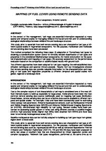
Pre-monsoon season , the hottest period, extends from April to June with temperatures ranging from 32oC to 45oC. The winter season is from January to March and temperature may drop to 0oC in some cities of Rajasthan, such as Churu. Materials and Methods The entire State of Rajasthan has been covered in 36 scenes of IRS P6 LISS III data. The multi-season data was chosen for optimal discrimination of various vegetation types. Ortho-rectified Landsat ETM+ datasets were downloaded from GLCF website (http://glcf.umiacs.umd.edu/). All the scenes were acquired and geometrically corrected with reference to Landsat ETM+ satellite data. The planimetric accuracy standards of ≤ 1 pixel error were achieved for all the scenes. The False Colour Composite (FCC) mosaic of IRS- P6 LISS-III data for the entire state of Rajasthan is shown in Figure 1. Landsat ETM+ (2001) and IRS P6 AWiFS (2008) datasets were also used for reference. The ancillary data of Survey of India toposheets on 1:50,000 scale and spatial datasets of Elevation data (from Shuttle Radar Topography Mission), DCW (Digital Chart of World), village location and road network was used in the study. Classification Scheme The vegetation delineation depends on spatial, spectral and temporal resolution of the satellite sensor on one hand and the spatial extent and degree of homogeneity of the species assemblages on the other hand. The forest class is subdivided into mixed species forest types, gregarious species forest types, locale specific types, degraded types based on composition and location specific distribution controlled by physiographic, edaphic and disturbance conditions. The sub classification under these classes was made based on phenology, physiognomy and dominant compositional patterns following the principles of Indian forest type classification developed by Champion and Seth (1968). Grasslands are primarily classified based on climatic, edaphic and species associations. The classification scheme of Dabadghao and Shankarnarayan (1973) was utilised with certain modifications. Visual interpretation of the vegetation types was carried out and different classes were interpreted using on screen digitization method. The interpreted product was further collaborated with ground truth information and phytosociological data. The interpreted vector layers of each district were mosaiced and the edge contrast and other inconsistencies were harmonized. Likewise, for all the 33 districts of Rajasthan, vegetation type maps were prepared on 1:50,000 scale. The vegetation type map of Rajasthan thus prepared is estimated to have an overall mapping accuracy of 89%. Field study Field surveys were undertaken to get acquainted with the general patterns of vegetation types of the study area. Major vegetation types and important localities of characteristic types were recorded. The variation and tonal patterns were observed on IRS P6 LISS III images. Stratified random sampling in the various vegetation types, further helps in classifying them up to community level. Phytosociological sample plot data of 1800 points were utilized in the study. To facilitate the on-screen visual interpretation, some site-specific vegetation types were identified and image chips were extracted from corresponding IRS P6 LISS-III scenes. All the unique image templates along with field information and photographs were made as geospatially referenced database for
Reddy et al.
003
Figure 1. IRS P6 LISS-III False Colour Composite image of Rajasthan
delineating similar such areas across the entire scene. The image templates were also evaluated across the scenes for the degree of conformity and to maintain uniformity across the scenes.
Results In Rajasthan, natural vegetation cover occupies 16.78% of the total geographical area (Figure 2, table 1). Among the five forest systems mapped at level 1, mixed formations occupy 79.22% of forest area followed by gregarious formations of 12.98%, degraded formations (3.68%) and forest plantations (3.50%) (Figure 3). The vegetation type map clearly showed that 4.71% of the geographical area is under forest cover. The major forest types delineated in the State are Broad leaved hill, Dry deciduous, Dhauk forest, Thorn, Teak mixed, Riverine forest, tree/shrub savannah and forest plantation. Scrub
and grasslands occupy significant area and represented with 9.18% and 2.87% of geographical area respectively. 2 Broad leaved hill forest occupies 80.25 km and unique to Mount Abu Wildlife Sanctuary of Sirohi district. Of the deciduous systems, mixed dry deciduous forest is dominant and occupies 10,443.81 km2 followed by 2 Anogeissus pendula Edgew. (1354.13 km ) and teak 2 (456.03 km ). Of the thorn vegetation system, mixed thorn forest represents 2252.16 km2 followed by Acacia senegal (L.) Willd. (212.19 km2) and Prosopis cineraria 2 (L.) Druce (72.12 km ). Riverine forest is a locale specific vegetation type accounted for an area of 99.69 km2. Being located in arid and semi-arid zone of India, 2 Rajasthan represents low area (4768.84 km ) under water bodies (including wetlands) and which occupies 1.39% of total geographical area. Agriculture is predominant land use in Rajasthan estimated as 250123.15 km2 (73.08%) of
004
E. J. Environ. Res. Manage.
Figure 2. Vegetation type and land use map of Rajasthan
geographical area. Discussion The important vegetation types of Rajasthan were discussed below: Broad leaved hill forests: Broad leaved hill forests (Central Indian subtropical hill forests (8A/C3) as per
Champion and Seth, 1968) of Rajasthan shows a mixture of evergreen and deciduous tree species. It is dominated by Mangifera indica L., Anogeissus sericea Brandis., Anogeissus lalifolia (Roxb. ex DC.) Well. ex Guill. and Perr., Lannea coromandelica (Houtt) Merr. and Syzygium cumini (L.) Skeels. Total area covered by this forest is 2 80.25 km (0.02% of total geographical area). There is a more of dry vegetation, which in its present form resembles dense dry deciduous forest though representing evergreen elements. The steep slopes mark
Reddy et al.
Table 1. Areal extent of Vegetation types and Land Use of Rajasthan (area in km2)
Sl.no.
Class
A
Forest
I
Mixed formations
1
2
Area (km )
Area (%)
Broad leaved hill forest
80.25
0.02
2
Dry Deciduous forest
10448.62
3.05
3
Thorn forest
2252.16
0.66
Sub total
12781.04
3.73
II
Gregarious formations
4
Dhauk forest (Anogeissus pendula Edgew.)
1354.13
0.40
5
Teak Mixed forest
456.03
0.13
6
Acacia senegal (L.) Willd
212.19
0.06
7
Prosopis cineraria (L.) Druce.
72.12
0.02
Sub total
2094.48
0.61
III
Locale Specific formations
8
Riverine forest
99.69
0.03
Sub total Degraded formations/Woodland
99.69
0.03
IV 9
Tree Savannah
468.44
0.14
10
Shrub Savannah
125.07
0.04
Sub total
593.52
0.17
V
Forest Plantation
11
Mixed Plantation
564.89
0.17
Sub total
564.89
0.17
B/VI
Scrub/Shrubland
12
Thorn Scrub
4788.36
1.40
13
Dry Deciduous Scrub
12440.38
3.63
14
Euphorbia Scrub
130.68
0.04
15
Prosopis juliflora (Swartz.) DC.Scrub
92.44
0.03
16
Desert Dune Scrub
13958.24
4.08
17
Lantana Scrub
8.26
0.002
18
Calotropis Scrub
4.77
0.001
19
Ravine scrub
48.47
0.01
Sub total
31471.61
9.20
C/VII
Grassland
20
Saline Grassland
25.36
0.01
21
Swampy Grassland
2.80
0.001
22
Lasiurus-Panicum Grassland
3339.45
0.98
23
Cenchrus-Dactyloctenium Grassland
5430.01
1.59
24
Aristida-Oropetium Grassland
80.15
0.02
005
006
E. J. Environ. Res. Manage. Table 1 Cont.
25
Sehima-Apluda Grassland
667.28
0.19
26
Aristida-Dichanthium Grassland
283.59
0.08
Sub total
9828.64
2.87
D/VIII
Orchards
321.11
0.09
E/IX
Agriculture
250123.15
73.08
F/X
Water bodies
4685.00
1.37
G/XI
Wetlands
83.84
0.02
H/XII
Long Fallow/Barren land
26439.93
7.73
I/XIII
Settlement
3152.17
0.92
Grand total
342239
100
Figure 3. Pie chart showing distribution of level 1 Forest categories
this terrain evident from other surroundings. Image shows these areas as bright tone with rough texture in both seasons. Dry Deciduous forest: It is equivalent to northern dry mixed deciduous forests (5B/C2). This forest type shows prominence of Anogeissus pendula Edgew. (Popularly known as Dhauk), Butea monosperma (Lam.) Taub, Lannea coromandelica (Houtt) Merr, Boswellia serrata Roxb ex Coleb, Anogeissus lalifolia (Roxb. ex DC.) Well. ex Guill. and Perr. and Diospyros melanoxylon Roxb. Dry Deciduous forests (Tropical Dry Deciduous forests according to Champion and Seth, 1968) occupy major proportion under natural vegetation cover and predominantly found in Udaipur, Rajsamand, Ajmer, Kota, Baran, Chittorgarh districts. It occurs at an altitude of around 200-600 mts. It is spreading over an area of
10,448.62 km2 (3.05% of TGA). In green season satellite image dry deciduous forest looks dark red in tone with rough texture, but in dry season the areas take up greenish shade with no evidence of foliage. Background reflectance of dry/often burnt undergrowth marks this system. Contiguity of these forests over large areas is common and can be generally found interspersed with contrasting fringing forests in dry season. Dhauk forest (Anogeissus pendula Edgew.): It is edaphic climax forest (6/E1) as per Champion and Seth' classifcation (1968). This type is largely determined by the Anogeissus pendula which forms nearly pure crops, often well stocked, about 6 m. height. These forests are predominantly found in northern Aravallis, central Aravallis and east of Aravallis. Profuse growth of Anogeissus pendula also found in Kumbalgarh wildlife
Reddy et al.
sanctuary in southern Aravallis. It is leafless from February - June. The associated species are those of dry deciduous forests. The rainfall ranges between 500-900 mm. Area covered by this type is 1354.13 km2. When browsing pressure is heavy the Anogeissus pendula is reduced to spreading and creeping forms. Teak mixed forest: It is known as dry teak forest (5A/C1b) according to Champion and Seth' s classification. Teak Mixed Dry Deciduous Forests are found in Southern region of Rajasthan Dungarpur and Banswara districts. Area covered by this type is 456.03 km2 (0.13% of TGA) The species composition in this type includes Tectona grandis L., Anogeissus lalifolia (Roxb. ex DC.) Well. ex Guill. and Perr., Butea monosperma (Lam.) Taub., Diospyros melanoxylon Roxb., Lannea coromandelica (Houtt) Merr and Boswellia serrata Roxb ex Coleb. On satellite image it gives appearance of dark brown tone with rough texture in December image but it gets mixed up with dry deciduous forest in dry season. One of the most characteristic features regarding association is the contiguous tracts prevailing in foot hills and on low altitude hills of the plateau. Relatively intense ground truthing is essential for confirmation, in spite of its characteristic smoky looking dry deciduous tone at places. Thorn forest: It is equivalent to northern tropical thorn forests (6B). Thorn forest are mostly found in Thar Desert and central Aravallis of Rajasthan. Common species in this type are Prosopis cineraria (L.) Druce., Acacia senegal (L.) Willd, Acacia nilotica (L.) Willd. ex Del, Acacia leucophloea (Roxb.) Willd., Acacia tortilis (Forssk.) Hyene.and Zizyphus mauritiana Lam. etc. Capparis decidua (Forssk.) Edgew.is indicator species of thorn forests in western Rajasthan. There is a less admixture of dry deciduous forest species as compared to its counter part of southern tropical thorn forests of Peninsular India (Champion and Seth, 1968). On image it gives a rough texture with light to dark tone in both dry and wet season image. Acacia senegal (L.) Willd forest: It is the edaphic type of thorn forest (6/E2) with Acacia senegal and few associated species like Acacia leucophloea (Roxb.) Willd. and Zizyphus nummularia (Burm.f.) Wight. and Arn. It is distributed in desert region and Aravallis. Prosopis cineraria (L.) Druce forest: It is a desert thorn forest (6B/C1) with extremely open crops of scattered trees. The delineation of Prosopis cineraria forest is subjective and based on the field knowledge and technical skills due to scattered trees here and there. Riverine (riparian) forest: These are referred as dry tropical riverain forests (5/1S1) in Champion and Seth's classification. Riverine forests are interspersed in
007
deciduous systems, wherever streams and rivers flow as surface channel over longer periods than surroundings. These areas are narrow strips along the hilly intersections of the large streams. The species constituting such forests include Syzygium heyneanum (Duthi.) Wall.ex Gamble, Terminalia arjuna (DC.) Wight and Arn., Syzygium cumini (L.) Skeels., Holoptelea integrifolia (Roxb.) Planchon., Ficus racemosa L. Almost near perfect contrasts are apparent during dry seasons on image. Image shows these areas as bright tone in both seasons. Woodland: It was referred as dry savannah forest (5/DS2) in Champion and Seth's classification. Depending on the mode of degradation, fire/grazing/edaphic conditions, the forest shows deterioration and becomes woodland. Based on the severity of disturbance, woodland of two types were common in Aravallis of Rajasthan and they are referred as Tree savannah and Shrub savannah. Tree savanna differs from shrub savanna only in tree height and spacing. Tree Savannah appears dark maroon with pinkish tinge tone and have medium to coarse texture. Shrub Savannah presents light maroon with cyan tinge tone and possess medium to coarse texture. Scrub: Scrub is a vegetation cover predominantly occupied by shrubs or poor tree growth chiefly of small or stunted trees with crown density less than 10%. It is the first most dominant vegetation class covering an area of 31,471.61 km2. Desert dune scrub occupies 13,958.24 km2 is unique to sandy parts of desert on partially stabilised dunes and on shifting dunes. It is the dominant scrub type of Rajasthan. Thorn scrub is generally seen in the fringes of thorn forests, hill tops and nearby settlements. Dry Deciduous scrub has been subjected to more degradation and frequently found in and around dry deciduous forests. Calotropis scrub is specifically found in long fallow areas and bordering crop fields in desert region. Euphorbia scrub is unique to rocky and badly eroded areas of both desert and Aravallis. It is a very open formation in which Euphorbia caducifolia Haines. predominates. Prosopis juliflora (Swartz.) DC. and Lantana camara L. are worst invasive alien species and threat to native biodiversity (Reddy, 2008). Prosopis juliflora and Lantana camara being aggressive colonizers, form dense thickets referred as Prosopis scrub and Lantana scrub, respectively. Prosopis juliflora often grows along road sides, canals and degraded thorn forest lands and rapidly spreading in desert and Aravallis. Lantana camara prefers openings and fringes of dry deciduous forests and subhumid tracts of broad leaved hill forests. Grasslands: Grasslands of Rajasthan have been grouped into seven types. All these grasslands are mapped based on habitat information, physical location and unique associations. Smooth texture less expanse
008
E. J. Environ. Res. Manage.
restricted to arid and semi-arid plains and hill slopes mark the land cover. Occasionally tree/shrub savannah is associated in the fringes of grasslands. It may mix with barren areas if single season data is used, though for an experienced interpreter the association induced distinction is hard to ignore. Lasiurus scindicus-Panicum turgidum grasslands are climax vegetation systems adapted to very low rainfall (