WATER QUALITY ASSESSMENT REPORT Yucca Loma Road/Yates Road/Green Tree Boulevard Transportation Improvement Project Town of Apple Valley, City of Victorville County of San Bernardino, California 08-SBD-STPL-5453(011)
Prepared for: State of California Department of Transportation, District 8 464 West 4th Street San Bernardino, CA 92401
and Town of Apple Valley 14955 Dale Evans Parkway Apple Valley, California 92307 Contact: Mark Abbott Project Manager
May 2009
EXECUTIVE SUMMARY The proposed Project will provide a new route across the Mojave River between the Town of Apple Valley, County of San Bernardino, and City of Victorville. The eastern limit of the proposed Project is at the intersection of Yucca Loma Road and Apple Valley Road. The western limit is at the intersection of Green Tree Boulevard and Hesperia Road. The proposed Project will widen Yucca Loma Road from two to four lanes from Apple Valley Road to its current terminus east of Kasanka Trail. A new bridge crossing over the Mojave River will be constructed extending the roadway to Yates Road. This bridge will be built wide enough for an ultimate build out use of six lanes but will be striped for four lanes. The bridge will also have shoulders and sidewalks. Space for sidewalk will be allowed on both sides of Yucca Loma Road; however, it is anticipated sidewalk will only be built on one side of the street as part of this proposed Project. A new signal with crosswalks is planned at Havasu Road. Yates Road will be widened from two lanes to four lanes. From Fortuna Lane to Park Road actual roadway widening is necessary. From Park Road to Ridgecrest Road, Yates Road is currently built wide enough for four lanes, but has been striped and used for two lanes of traffic. Pavement rehabilitation and restriping is needed in this area. Yates Road as it connects to Ridgecrest Road will be realigned to the east to allow connection to an extension of Green Tree Boulevard. A pedestrian path is planned along the north side of Yates Road, connecting from the bridge over the Mojave River to Ridgecrest Road and Green Tree Boulevard. Ridgecrest Road will be realigned, at its current width, from approximately five hundred feet south of Chinquapin Drive to a new intersection of Yates Road and the extension of Green Tree Boulevard. Signals are planned at the new intersection and sidewalks will connect the three streets. Green Tree Boulevard will be extended with four thru travel lanes from the new Ridgecrest Road/Yates Road intersection to Hesperia Road by following one of two alternate alignments. The Green Tree Boulevard South alignment, Alternative A, is centered on the existing property Section Line boundary and impacts four single family residential parcels located between the railroad right-of-way and Hesperia Road. Alternative B, the Green Tree Boulevard North alignment, shifts the roadway approximately 150 feet to the north, avoiding the four single family residential parcels. New access roads would maintain access to the four parcels. Grading would allow for sidewalk to be built on both sides of the roadway; however, construction of sidewalks is anticipated to occur as development in the area occurs. Both Green Tree Boulevard alignment alternatives require the construction of a new bridge over the BNSF Railroad which will also be striped for four lanes and include sidewalks. Various utility relocations and realignments will be necessary throughout the proposed Project. An analysis was conducted to assess the water quality constraints of the proposed Project, the results of which determined that both construction activity and post-construction impacts may affect water quality; however, with implementation of Best Management Practices (BMPs)
Yucca Loma Bridge/ Yates Road/ Green Tree Boulevard Transportation Improvement Project Water Quality Assessment Report May 2009
ii
these impacts should remain minimal. The temporary and permanent impacts of the proposed Project are summarized below. Construction of the Bridge will require work in and adjacent to the Mojave River; therefore there is a potential for pollutants from construction work to enter the intermittent water body. The proposed Project’s temporary impacts are confined to the portion of the river channel that will be disturbed for placement of posts to support construction falsework. Permanent impacts for the proposed Project include the excavation and placement of piers within the river channel and placement of the abutments on the banks. The Mojave River is the only major creek, river, or stream within the proposed Project Vicinity. The characteristics of the Mojave River are: •
A high percolation rate of the riverbed material
•
A channel that is dry most of the year
•
The flow is controlled by United States Army Corps of Engineers (USACE), Los Angeles District
A construction Storm Water Pollution Prevention Plan (SWPPP) will be prepared that identifies the specific Best Management Practices (BMPs) to be implemented during proposed Project construction so as not to cause or contribute to an exceedance of any water quality standards specified in the Water Quality Control Plan for the Lahontan Region (Basin Plan). Adverse impacts to water quality could result from both construction activity and postconstruction impacts. Since the proposed Project will be creating a new bridge and widening Yucca Loma Road and Yates Road, the proposed Project is anticipated to produce approximately 22 acres of new impervious surface and introduce small amounts of additional pollutant loads of runoff into the area, 4 acres will be impacts from the Mojave River Bridge. Yucca Loma Road widening will constitute another 5 acres of the 22 total acres and the Yates Road Widening will contribute the additional 13 acres of impervious surfaces. The proposed Project is required to implement routine structural BMPs to target pollutants of concern. Design Pollution Prevention, Treatment, and Maintenance BMPs will be specified during the design phase of the proposed Project. If the SWPPP and BMPs are implemented in accordance with National Pollutant Discharge Elimination System (NPDES) permit requirements as stipulated in Mitigation Measures WQ1 (Obtain General Construction Permit and Prepare SWPPP), WQ-2 (Erosion Control Measures), WQ-3 (Implement a Spill Prevention and Control Program), WQ-4 (Include SWPPP Standards and Criteria), and WQ-6 (Removal of All Temporary Measures), and Biology measures BIO-1 (Protect Water Quality and Prevent Erosion in Wetlands and Drainages), BIO-2 (Implement Water Quality Measures), BIO-3 (Avoidance and Minimization Efforts for Sensitive Natural Communities), BIO-4 and (Avoidance and Minimization Efforts for Aquatic Resources) the requirements would ensure that construction does not cause adverse impacts to water quality. Also, because the proposed Project consists of a permanent increase in impervious surfaces, there remains potential for a permanent increase in runoff and pollutant loading without Yucca Loma Bridge/ Yates Road/ Green Tree Boulevard Transportation Improvement Project Water Quality Assessment Report May 2009
iii
implementation of construction, design, and treatment BMPs. Additional minimization measures WQ-5 (Appropriate Treatment BMPs During Final Design), including measures such as implementation of detention basins and using local standards when feasible, would prevent adverse water quality impacts from post-construction operation of the bridge and improved roadways.
Yucca Loma Bridge/ Yates Road/ Green Tree Boulevard Transportation Improvement Project Water Quality Assessment Report May 2009
iv
TABLE OF CONTENTS EXECUTIVE SUMMARY ................................................................................................................................. ii 1.
INTRODUCTION.........................................................................................................................................2 1.1 PROJECT PURPOSE AND NEED ...................................................................................................................2 1.2 PROJECT DESCRIPTION ..............................................................................................................................2 1.3 APPROACHES TO WATER QUALITY ASSESSMENT .....................................................................................4
2.
REGULATORY SETTING........................................................................................................................10 2.1 FEDERAL REQUIREMENTS .......................................................................................................................10 Federal Clean Water Act ........................................................................................................................10 2.2 STATE REQUIREMENTS ...........................................................................................................................11 Porter-Cologne Water Quality Control Act............................................................................................11 California Fish and Game Code Sections 1601-1603 ............................................................................11 State Requirements under Section 402 of the Federal Clean Water Act ................................................12 2.3 LOCAL REQUIREMENTS ...........................................................................................................................12 Local Requirements under Section 402 of the Federal Clean Water Act...............................................12 Basin Plan Beneficial Uses ....................................................................................................................13 Water Quality Objectives .......................................................................................................................14
3.
AFFECTED ENVIRONMENT..................................................................................................................24 3.1 SURFACE WATER RESOURCES ................................................................................................................24 3.2 GROUNDWATER RESOURCES ..................................................................................................................24 3.3 TOPOGRAPHY ..........................................................................................................................................25 3.4 SOILS/ EROSION POTENTIAL ...................................................................................................................25 3.5 CLIMATE AND PRECIPITATION ................................................................................................................26 3.6 POPULATION AND LAND USE ..................................................................................................................26 Town of Apple Valley............................................................................................................................26 City of Victorville ..................................................................................................................................26 County of San Bernardino......................................................................................................................27 3.7 EXISTING WATER QUALITY ....................................................................................................................27 3.8 POLLUTANTS OF CONCERN .....................................................................................................................29 Sediment.................................................................................................................................................29 Nutrients.................................................................................................................................................29 Bacteria and Viruses ..............................................................................................................................29 Organic Compounds...............................................................................................................................29 Oxygen-Demanding Substances ............................................................................................................30 Trash and Debris ....................................................................................................................................30 Oil and Grease........................................................................................................................................30 Pesticides................................................................................................................................................30 Metals.....................................................................................................................................................30
4.
ENVIRONMENTAL CONSEQUENCES.................................................................................................31 4.1 IMPACT ASSESSMENT METHODOLOGY ...................................................................................................31 4.2 POTENTIAL IMPACTS TO WATER QUALITY .............................................................................................31 Construction Impacts .............................................................................................................................31 Post-Construction Impacts .....................................................................................................................34
5.
AVOIDANCE, MINIMIZATION, and/or MITIGATION MEASURES...............................................35 5.1 APPLICABLE BEST MANAGEMENT PRACTICES AND MITIGATION MEASURES .........................................35 Temporary Measures..............................................................................................................................35 Permanent Measures ..............................................................................................................................41
6.
REFERENCES ............................................................................................................................................42
Yucca Loma Bridge/ Yates Road/ Green Tree Boulevard Transportation Improvement Project Water Quality Assessment Report May 2009
i
LIST OF FIGURES Figure 1: Figure 2: Figure 3: Figure 4: Figure 5:
Project Vicinity ......................................................................................................................................6 Location Map .........................................................................................................................................8 Mojave Hydrologic Area .....................................................................................................................18 Mojave Hydrologic Unit San Bernardino Mountains Area..................................................................19 Mojave Groundwater Basin .................................................................................................................22
LIST OF TABLES Table 1: Table 2: Table 3: Table 4: Table 5: Table 6: Table 7: Table 8: Table 9:
Beneficial Uses ....................................................................................................................................13 General Surface Water Quality Objectives.........................................................................................14 Certain Water Bodies- Mojave Hydrologic Unit, Water Quality Objectives ...................................16 Water Bodies- San Bernardino Mountains Area, Mojave Hydrologic Unit Water Quality Objectives.............................................................................................................................................17 General Objectives for Groundwater ..................................................................................................20 Average Low, Mean, and High Temperatures for Apple Valley/ Victorville and Average Precipitation .........................................................................................................................................26 Existing Water Quality in Mojave River at Lower Narrows 2005-2006 ..........................................27 Increase in Impervious Area ...............................................................................................................31 Construction BMPs..............................................................................................................................33
Yucca Loma Bridge/ Yates Road/ Green Tree Boulevard Transportation Improvement Project Water Quality Assessment Report May 2009
ii
Yucca Loma Bridge/ Yates Road/ Green Tree Boulevard Transportation Improvement Project Water Quality Assessment Report May 2009
1
1.
INTRODUCTION
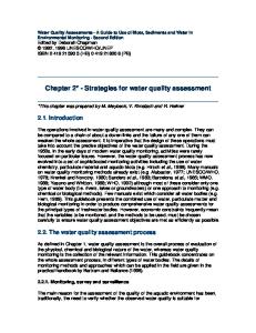
The Town of Apple Valley (Town), in association with the City of Victorville (City), proposes to provide a new route across the Mojave River including necessary improvements and realignments to Yates Road, Yucca Loma Road, Green Tree Boulevard, and Ridgecrest Road. The proposed Project is located within the Town of Apple Valley and the City of Victorville with the eastern proposed Project limits in Apple Valley at the intersection of Yucca Loma Road and Apple Valley Road and the western limit in Victorville at the intersection of Green Tree Boulevard and Hesperia Road (Figure 1). The purpose of this report is to evaluate impacts of this proposed Project on potentially affected water resources and their beneficial uses. This report is intended to evaluate the existing surface and groundwater resources and the potential effects of the proposed Project on these water resources.
1.1
PROJECT PURPOSE AND NEED
The purpose of the proposed Project is to establish an alternate route between the Town of Apple Valley and the City of Victorville in the County of San Bernardino, California. The Mojave River is a natural barrier between the Town of Apple Valley to the east and the City of Victorville to the west. Significant growth in the area has created traffic “bottle-necks” at the two existing river crossings located at Bear Valley Road and State Route 18. With further population growth and without a new river crossing, conditions are expected to be further aggravated. This proposed Project would provide a new major arterial connection through these three jurisdictions which would provide better access to the existing local residential neighborhoods, to the local freeway system, and to the Mojave Narrows Regional Park. The proposed Project is designed to reduce traffic volume and congestion on the existing routes connecting the City of Victorville and the Town of Apple Valley (Bear Valley Road to the south and State Route 18 to the north), as well as increase residential, commercial, and industrial development in both the City of Victorville and the Town of Apple Valley. In addition to the reduction of traffic congestion, the proposed Project would also benefit traffic safety and air quality in the region. By reducing stop and go traffic, the potential for traffic related accidents would decrease. The new route would reduce Vehicle Miles Traveled and Vehicle Hours Traveled which would reduce vehicle emissions. The proposed Project includes the construction of a new bridge over the Mojave River which would reduce the existing vehicular impacts to the river bed and surrounding areas during the dry season. Construction of the proposed Project would be an implementation of the General Plans from the City of Victorville, the County of San Bernardino, and the Town of Apple Valley.
1.2
PROJECT DESCRIPTION
The proposed Project will provide a new route across the Mojave River between the Town of Apple Valley, County of San Bernardino, and City of Victorville (Figure 1). The eastern limit of the proposed Project is at the intersection of Yucca Loma Road and Apple Valley Road. The western limit is at the intersection of Green Tree Boulevard and Hesperia Road. The proposed Project will widen Yucca Loma Road from two to four lanes from Apple Valley Road to its current terminus east of Kasanka Trail. A new bridge crossing over the Mojave River will be constructed extending the roadway to Yates Road. This bridge will be built wide enough for an ultimate build out use of six lanes but will be striped for four lanes. The bridge Yucca Loma Bridge/ Yates Road/ Green Tree Boulevard Transportation Improvement Project Water Quality Assessment Report May 2009
2
will also have shoulders and sidewalks. Space for sidewalk will be allowed on both sides of Yucca Loma Road; however, it is anticipated sidewalk will only be built on one side of the street as part of this proposed Project. A new signal with crosswalks is planned at Havasu Road. Yates Road will be widened from two lanes to four lanes. From Fortuna Lane to Park Road actual roadway widening is necessary. From Park Road to Ridgecrest Road, Yates Road is currently built wide enough for four lanes, but has been striped and used for two lanes of traffic. Pavement rehabilitation and restriping is needed in this area. Yates Road as it connects to Ridgecrest Road will be realigned to the east to allow connection to an extension of Green Tree Boulevard. A pedestrian path is planned along the north side of Yates Road, connecting from the bridge over the Mojave River to Ridgecrest Road and Green Tree Boulevard. Ridgecrest Road will be realigned, at its current width, from approximately five hundred feet south of Chinquapin Drive to a new intersection of Yates Road and the extension of Green Tree Boulevard. Signals are planned at the new intersection and sidewalks will connect the three streets. Green Tree Boulevard will be extended with four through travel lanes from the new Ridgecrest Road/Yates Road intersection to Hesperia Road by following one of two alternate alignments. The Green Tree Boulevard South alignment, Alternative A, is centered on the existing property Section Line boundary and impacts four single family residential parcels located between the railroad right-of-way and Hesperia Road. Alternative B, the Green Tree Boulevard North alignment, shifts the roadway approximately 150 feet to the north, avoiding the four single family residential parcels. New access roads would maintain access to the four parcels. Grading would allow for sidewalk to be built on both sides of the roadway; however, construction of sidewalks is anticipated to occur as development in the area occurs. Both Green Tree Boulevard alignment alternatives require the construction of a new bridge over the BNSF Railroad which will also be striped for four lanes and include sidewalks (for the purpose of this Water Quality Assessment, the described section of Green Tree Boulevard is not adjacent to the Mojave River and requires no additional discussion). Various utility relocations and realignments will be necessary throughout the proposed Project. Since the proposed Project is located in three different jurisdictions, it is anticipated construction will occur under multiple construction contracts and during different construction seasons. Construction may begin as early as 2010. The proposed Project’s regional location is shown in Figure 1: Vicinity Map and Figure 2: Locality Map. Funding sources for the proposed Project include local funds (the Town of Apple Valley, the City of Victorville, the County of San Bernardino and the State of California) as well as federal funds provided by the Surface Transportation Program (Local). Construction is scheduled to begin in 2010. The proposed Project will be constructed in accordance with Department Standard Construction Specifications, which include measures to reduce noise and air pollution emissions during construction. Yucca Loma Bridge/ Yates Road/ Green Tree Boulevard Transportation Improvement Project Water Quality Assessment Report May 2009
3
1.3
APPROACHES TO WATER QUALITY ASSESSMENT
The purpose of this Water Quality Assessment Report is to determine whether the proposed Yucca Loma Bridge/Yates Road/Green Tree Boulevard Transportation Improvement Project will have an adverse impact on water quality. The determination of impacts is based on the anticipated change in pollutant loads due to construction activities required in the stream channels, the excavation required on land in proximity to the stream banks, pollutant loads anticipated during construction, and changes in impervious area percentage between the existing condition and the post-Project condition. The analysis includes consideration of Best Management Practices (BMPs) to be implemented as part of the proposed Project. This assessment also discusses existing water quality regulations and the methods for complying with those regulations.
Yucca Loma Bridge/ Yates Road/ Green Tree Boulevard Transportation Improvement Project Water Quality Assessment Report May 2009
4
Yucca Loma Bridge/ Yates Road/ Green Tree Boulevard Transportation Improvement Project Water Quality Assessment Report May 2009
5
St
Nye
Inyo
18
h
18 Tulare
6t
Clark Mohave
15
Kern 18
San Bernardino
40
Los Angeles
Project Vicinity 10
Orange
215
Riverside
San Diego
La Paz
Imperial
Yuma
Mojave Narrows Regional Park
s Ya te
Project Location
Rd
Yucca Loma Rd
A A ll tt .. B B
Fortuna Ln
A A ll tt .. A A
Spring Valley Lake
Sp
Coad Rd
r in
Gre en Tre e Blv d
Sen eca Rd
yP alle gV
Ridg ecre st Rd
Hesperia Rd
V:\1688_YuccaLoma\VicinityMap
App le Valley Rd
BNSF Railroad
ky
Nisqualli Rd
Bea r Valle y Rd
Source: USGS Victorville (1956, revised 1993), Apple Valley North (1970, revised 1993), Hesparia (1956, photorevised 1980), and Apple Valley South (1956) 7.5 Minute Quadrangles; Dokken Engineering, 2009; Created by: K. Smith
FIGURE 1 Project Vicinity
0
0.5
Yucca Loma Road/Yates Road/Greentree Boulevard Transporation Improvement Project District 8 1 STPL 5453(011) Miles Town of Apple Valley, County of San Bernardino, and City of Victorville
Yucca Loma Bridge/ Yates Road/ Green Tree Boulevard Transportation Improvement Project Water Quality Assessment Report May 2009
7
Seneca Rd
Mojave Narrows Regional Park Horseshoe Lake
s Yate
Rd
ja Mo r ve Ri ve
Green Tree Blvd
Yucca Loma Rd
AA ll tt .. BB
Fortuna Ln
AA ll tt .. AA
Spring Valley Lake
Sp
Coad Rd
alle gV
V:\1688_YuccaLoma\VicinityMap
rin ky yP
Source: GlobalXplorer 3/1/2008; Dokken Engineering, 2009; Created By: K. Smith
FIGURE 2
Project Location
1 Miles
d
0.5
ad
0
Yucca Loma Road/Yates Road/Greentree Boulevard Transporation Improvement Project District 8 STPL 5453(011) Town of Apple Valley, County of San Bernardino, and City of Victorville
Yucca Loma Bridge/ Yates Road/ Green Tree Boulevard Transportation Improvement Project Water Quality Assessment Report May 2009
9
2.
REGULATORY SETTING
Discharges into waters of the United States are subject to the regulatory authority of the U.S. Army Corps of Engineers (Corps) under Section 404 of the federal Clean Water Act (CWA); the State Water Resources Control Board (SWRCB) and the Southern Lahontan Regional Water Quality Control Board (LRWQCB) under Sections 401, 402, and 303(d) of the CWA and the California Porter-Cologne Water Quality Act, and by the California Department of Fish and Game (CDFG) under Sections 1601-1603 of the California Fish and Game Code.
2.1
FEDERAL REQUIREMENTS
Federal Clean Water Act Section 404 The Corps regulates discharges or fills into waters of the United States under Section 404 of the CWA via the Nationwide Permit (NWP) or Individual Permit program. There are several categories of NWPs, and these can be used for proposed Projects that fall under specific categories. A Preconstruction Notification (PCN) to the Corps district engineer is required for most activities that result in the loss of greater than 0.04 hectare (0.1 acre) of waters of the U.S. The Corps reviews the PCN on a case-by-case basis to determine whether the adverse effects (on the aquatic environment) of proposed work are minimal. The Corps will also determine whether a particular drainage is considered Waters of the U.S. and whether it is subject to regulation under Section 404. Section 402 Direct discharges of pollutants into waters of the United States are not allowed, except in accordance with the National Pollution Discharge Elimination System (NPDES) program established in Section 402 of the CWA. The major purpose of the NPDES program is to protect human health and the environment. Pursuant to the NPDES program, permits that apply to storm water discharges from MS4s, specific industrial activities, and construction activities [0.4 hectare (1 acre) or more] have been issued. NPDES permits establish enforceable effluent limitations on discharges, require monitoring of discharges, designate reporting requirements, and require the permittee to perform BMPs. Industrial (point source) storm water permits are required to meet effluent limitations; municipal permits are governed by the Maximum Extent Practicable (MEP) or Best Available Technology (BAT)/Best Control Technology (BCT) application of BMPs. Section 401 Section 401 of the CWA specifies that any applicant for a federal license or permit to conduct any activity, including but not limited to the construction or operation of facilities that may result in any discharge into navigable waters, shall provide the federal licensing or permitting agency with a certification from the State in which the discharge originates or will originate from the State agency with jurisdiction over those waters (LRWQCB) that the proposed Project will comply with water quality standards, protect beneficial uses, meet water quality objectives, and comply with the State anti-degradation policy. Yucca Loma Bridge/ Yates Road/ Green Tree Boulevard Transportation Improvement Project Water Quality Assessment Report May 2009
10
Section 303 Section 303(d) of the Clean Water Act requires that the State adopt water quality objectives for surface waters. The Basin Plan and Resolution No. 2004 - 0001contain water quality objectives that are considered necessary to protect the specific beneficial uses the Basin Plan identifies. Section 303(d) specifically requires the State to develop a list of impaired water bodies and subsequent numeric Total Maximum Daily Loads (TMDL) for whichever constituents impair a particular water body. These constituents include inorganic and organic chemical compounds, metals, sediment, and biological agents. The TMDL is the total amount of a constituent that can be discharged while meeting water quality objectives and protecting beneficial uses. It is the sum of the individual load allocations for point source inputs (e.g., an industrial plant), load allocations for nonpoint source inputs (e.g., runoff from urban areas), and natural background, with a margin of safety. The most recent 303 (d) impaired waters list for the State was approved by the SWRCB in 2006 shows that the Mojave River is not proposed or listed for any known pollutant or stressor. Deep Creek and West Fork Mojave are Mojave tributaries that are also unlisted. Verification that the Mojave River is not listed for impairments or TMDLs can be accessed on the internet on the SWRCB website at: www.waterboards.ca.gov/tmdl/docs/303dlists2006/final/r6_final303dlist.pdf www.waterboards.ca.gov/tmdl/docs/303dlists2006/final/statetcl_final303d.pdf.
2.2
STATE REQUIREMENTS
Porter-Cologne Water Quality Control Act The Porter-Cologne Act establishes a regulatory program to protect water quality and beneficial uses of State waters. It empowers the Regional Boards to formulate and adopt, for all areas within the regions, a Basin Plan that designates beneficial uses and establishes such water quality objectives that in its judgment will ensure reasonable protection of beneficial uses. Each Regional Board establishes water quality objectives that will ensure the reasonable protection of beneficial uses and the prevention of nuisance. The Water Code provides flexibility for some change in water quality, provided that beneficial uses are not adversely affected.
California Fish and Game Code Sections 1601-1603 The CDFG, through provisions of the California Fish and Game Code (Sections 1601-1603), is empowered to issue agreements for any alteration of a river, stream, or lake where fish or wildlife resources may be adversely affected. Streams and rivers are defined by the presence of a channel bed and banks and at least an intermittent flow of water. CDFG typically extends the limits of its jurisdiction laterally beyond the channel banks for streams that support riparian vegetation. In these situations, the outer edge of the riparian vegetation is generally used as the lateral extent of the stream and CDFG jurisdiction.
Yucca Loma Bridge/ Yates Road/ Green Tree Boulevard Transportation Improvement Project Water Quality Assessment Report May 2009
11
The California Fish and Game Code Section 1602 requires any person, State or local governmental agency, or public utility to notify the CDFG before beginning any activity that will result in one or more of the following: (1) substantial obstruction or diversion of the natural flow of a river, stream, or lake, (2) substantial change in or use of any material from the bed, channel, or bank of a river, stream, or lake, or (3) deposit or disposal of debris, waste, or other material containing crumbled, flaked, or ground pavement where it can pass into a river, stream, or lake. The Fish and Game Code Section 1602 applies to all perennial, intermittent, and ephemeral rivers, streams, and lakes in the State.
State Requirements under Section 402 of the Federal Clean Water Act General Construction Activity NPDES Permit (General Permit) In accordance with National Pollution Discharge Elimination System (NPDES) regulations, the State requires that any construction activity disturbing 1 acre or more of soil comply with the State General Construction Permit (NO. CAS000002). In order to obtain authorization for proposed storm water discharge pursuant to this permit, the landowner (discharger) is required to submit a Notice of Intent to the SWRCB, prepare a SWPPP, and implement BMPs detailed in the SWPPP during construction activities. Dischargers are required to implement BAT and BCT to reduce or eliminate storm water pollution. The purpose of the SWPPP is to prevent all construction pollutants from contacting storm water and to keep all products of erosion from moving off site into receiving waters. The proposed Project is subject to the requirements of this permit because it will disturb more than 1 acre of soil.
2.3
LOCAL REQUIREMENTS
Local Requirements under Section 402 of the Federal Clean Water Act Municipal NPDES Permit The Town of Apple Valley, County of San Bernardino, and Cities of Victorville and Hesperia are all covered under the same NPDES MS4 Permit (WQ Order No. 2003-0005-DWQ) program as individual Urbanized Areas as designated by the Bureau of Census. The Mojave Watershed Stormwater Management Plan (SWMP) required for the City under Phase II of the NPDES Stormwater Program. The MS4 permit requires the discharger to develop and implement a Storm Water Management Plan/Program with the goal of reducing the discharge of pollutants to the maximum extent practicable (MEP). MEP is the performance standard specified in Section 402(p) of the Clean Water Act. The management programs specify what Best Management Practices (BMPs) will be used to address certain program areas. The program areas include public education and outreach; illicit discharge detection and elimination; construction and post-construction; and good housekeeping for municipal operations. In general, medium and large municipalities are required to conduct chemical monitoring, though small municipalities are not. The management measures outlined in the SWMP are intended to be regionally integrated by each individual participant and are pertinent to the current proposed Project.
Yucca Loma Bridge/ Yates Road/ Green Tree Boulevard Transportation Improvement Project Water Quality Assessment Report May 2009
12
Basin Plan Beneficial Uses Beneficial uses of the Upper Mojave River Watershed are outlined in the Basin Plan. Beneficial uses of water are those necessary for the survival or well-being of humans, plants, and wildlife. Examples of beneficial uses include drinking water supplies, swimming, industrial and agricultural water supply, and the support of freshwater and marine habitats and their organisms. Beneficial Uses for Surface Waters The designated beneficial uses for the Mojave River and the West Fork of the Mojave River are listed in Table 1. Table 1: Beneficial Uses Category
Definition
Municipal and Domestic Supply
MUN
Uses of water for community, military, or individual water supply systems including, but not limited to, drinking water supply.
Agricultural Supply
AGR
Uses of waters for farming, horticulture, or ranching including, but not limited to, irrigation, stock watering, or support of vegetation for range grazing.
Ground Water Recharge
GWR
Uses of waters used for natural or artificial recharge of ground water for purposes of future extraction, maintenance of water quality, or halting of saltwater intrusion into freshwater aquifers. Ground water recharge includes recharge of surface water underflow.
Water Contact Recreation
REC-1
Uses of waters for recreational activities involving body contact with water, where ingestion of water is reasonably possible. These uses include, but are not limited to, swimming, wading, waterskiing, skin and scuba diving, surfing, white water activities, fishing, or use of natural hot springs.
Non-Contact Water Recreation
REC-2
Uses of waters for recreational activities involving proximity to water, but not normally involving body contact with water, where ingestion of water is reasonably possible. These uses include, but are not limited to, picnicking, sunbathing, hiking, beachcombing, camping, boating tidepool and marine life study, hunting, sightseeing, or aesthetic enjoyment in conjunction with the above activities.
Commercial and Sport Fishing
COMM
Uses of waters for commercial or recreational collection of fish, shellfish, or other organisms including, but not limited to, uses involving organisms intended for human consumption or bait purposes.
Warm Fresh Water Habitat
WARM
Uses of waters that support warm water ecosystems including, but not limited to, preservation or enhancement of aquatic habitats, vegetation, fish, or wildlife, including invertebrates.
Cold Fresh Water Habitat
COLD
Uses of waters that support cold water ecosystems including, but not limited to, preservation or enhancement of aquatic habitats, vegetation, fish or wildlife, including invertebrates.
Wildlife Habitat
WILD
Uses of waters that support terrestrial ecosystems including, but not limited to, preservation and enhancement of terrestrial habitats, vegetation, wildlife (e.g., mammals, birds, reptiles, amphibians, invertebrates), or wildlife water and food sources.
Beneficial Uses for Ground Waters Ground water throughout the Mojave Basin is suitable for agricultural water supply, municipal and domestic water supply, freshwater replenishment, aquaculture, and industrial use.
Yucca Loma Bridge/ Yates Road/ Green Tree Boulevard Transportation Improvement Project Water Quality Assessment Report May 2009
13
Water Quality Objectives As required by the Porter-Cologne Act, the LRWQCB has developed water quality objectives for waters within its jurisdiction to protect the beneficial uses of those waters and has published them in the Basin Plan. The Basin Plan also establishes implementation programs to achieve these water quality objectives and requires monitoring to evaluate the effectiveness of these programs. Water quality objectives must comply with the State anti-degradation policy (State Board Resolution No. 68-16), which is designed to maintain high-quality waters while allowing some flexibility if beneficial uses are not unreasonably affected. Surface Water Quality Objectives Surface water quality objectives for all waters established in the Basin Plan are listed in Tables 2 to 4 and include both general objectives and objectives specific to pertinent specific hydrologic units. Surface water monitoring stations within the Mojave Hydrologic Unit are shown in Figures 3 and 4. Table 2: General Surface Water Quality Objectives Constituent
Concentration
Ammonia
The neutral, unionized ammonia species (NH3) is highly toxic to freshwater fish. The fraction of toxic NH3 to total ammonia species (NH4 + + NH3) is a function of temperature and pH. Tables 3-1 to 3-4 were derived from USEPA ammonia criteria for freshwater. Ammonia concentrations shall not exceed the values listed for the corresponding conditions in these tables. Waters shall not contain concentrations of coliform organisms attributable to anthropogenic sources, including human and livestock wastes. The fecal coliform concentration during any 30-day period shall not exceed a log mean of 20/100 ml, nor shall more than 10 percent of all samples collected during any 30-day period exceed 40/100 ml. Waters shall not contain biostimulatory substances in concentrations that promote aquatic growths to the extent that such growths cause nuisance or adversely affect the water for beneficial uses. Waters designated as MUN shall not contain concentrations of chemical constituents in excess of the maximum contaminant level (MCL) or secondary maximum contaminant level (SMCL) based upon drinking water standards specified in the following provisions of Title 22 of the California Code of Regulations which are incorporated by reference into the Basin Plan: Table 64431-A of Section 64431 (Inorganic Chemicals), Table 64431-B of Section 64431 (Fluoride), Table 64444-A of Section 64444 (Organic Chemicals), Table 64449-A of Section 64449 (Secondary Maximum Contaminant Levels- Consumer Acceptance Limits), and Table 64449-B of Section 64449 (Secondary Maximum Contaminant Levels-Ranges). The incorporation-by-reference is prospective including future changes to the incorporated provisions as the changes take effect. Waters designated as AGR shall not contain concentrations of chemical constituents in amounts that adversely affect the water for beneficial uses (i.e., agricultural purposes). Waters shall not contain concentrations of chemical constituents in amounts that adversely affect the water for beneficial uses. For the protection of aquatic life, total chlorine residual shall not exceed either a median value of 0.002 mg/L or a maximum value of 0.003 mg/L. Median values shall be based on daily measurements taken within any six-month period. Waters shall be free of coloration that causes nuisance or adversely affects the water for beneficial uses.
Bacteria, Coliform
Biostimulatory Substances
Chemical Constituents
Chlorine, Total Residual
Color
Yucca Loma Bridge/ Yates Road/ Green Tree Boulevard Transportation Improvement Project Water Quality Assessment Report May 2009
14
Constituent
Concentration
Dissolved Oxygen
The dissolved oxygen concentration, as percent saturation, shall not be depressed by more than 10 percent, nor shall the minimum dissolved oxygen concentration be less than 80 percent of saturation. For waters with the beneficial uses of COLD, COLD with SPWN, WARM, and WARM with SPWN, the minimum dissolved oxygen concentration shall not be less than that specified in Table 3-6 of the Basin Plan. Waters shall not contain floating material, including solids, liquids, foams, and scum, in concentrations that cause nuisance or adversely affect the water for beneficial uses. For natural high quality waters, the concentrations of floating material shall not be altered to the extent that such alterations are discernable at the 10 percent significance level. Waters shall not contain oils, greases, waxes or other materials in concentrations that result in a visible film or coating on the surface of the water or on objects in the water, that cause nuisance, or that otherwise adversely affect the water for beneficial uses. For natural high quality waters, the concentration of oils, greases, or other film or coat generating substances shall not be altered. All wetlands shall be free from substances attributable to wastewater or other discharges that produce adverse physiological responses in humans, animals, or plants; or which lead to the presence of undesirable or nuisance aquatic life. All wetlands shall be free from activities that would substantially impair the biological community as it naturally occurs due to physical, chemical and hydrologic processes. For the purposes of this Basin Plan, pesticides are defined to include insecticides, herbicides, rodenticides, fungicides, piscicides and all other economic poisons. An economic poison is any substance intended to prevent, repel, destroy, or mitigate the damage from insects, rodents, predatory animals, bacteria, fungi or weeds capable of infesting or harming vegetation, humans, or animals (CA Agriculture Code. 12753). Pesticide concentrations, individually or collectively, shall not exceed the lowest detectable levels, using the most recent detection procedures available. There shall not be an increase in pesticide concentrations found in bottom sediments. There shall be no detectable increase in bioaccumulation of pesticides in aquatic life. Waters designated as MUN shall not contain concentrations of pesticides or herbicides in excess of the limiting concentrations specified in Table 64444-A of Section 64444 (Organic Chemicals) of Title 22 of the California Code of Regulations which is incorporated by reference into the Basin Plan. The incorporation-by-reference is prospective including future changes to the incorporated provisions as the changes take effect. In fresh waters with designated beneficial uses of COLD or WARM, changes in normal ambient pH levels shall not exceed 0.5 pH units. For all other waters of the Region, the pH shall not be depressed below 6.5 nor raised above 8.5. The Regional Board recognizes that some waters of the Region may have natural pH levels outside of the 6.5 to 8.5 range. Compliance with the pH objective for these waters will be determined on a case-by-case basis. Radionuclides shall not be present in concentrations which are deleterious to human, plant, animal, or aquatic life or which result in the accumulation of radionuclides in the food web to an extent which presents a hazard to human, plant, animal, or aquatic life. Waters designated as MUN shall not contain concentrations of radionuclides in excess of the limits specified in Table 4 of Section 64443 (Radioactivity) of Title 22 of the California Code of Regulations which is incorporated by reference into the Basin Plan. The incorporation-byreference is prospective including future changes to the incorporated provisions as the changes take effect. The suspended sediment load and suspended sediment discharge rate of surface waters shall not be altered in such a manner as to cause nuisance or adversely affect the water for beneficial uses. Waters shall not contain substances in concentrations that result in deposition of material that causes nuisance or that adversely affects the water for beneficial uses. For natural high quality waters, the concentration of settleable materials shall not be raised by more that 0.1 milliliter per liter.
Floating Materials
Oil and Grease
Nondegradation of Aquatic Communities and Populations
Pesticides
pH
Radioactivity
Sediment
Settleable Materials
Yucca Loma Bridge/ Yates Road/ Green Tree Boulevard Transportation Improvement Project Water Quality Assessment Report May 2009
15
Constituent
Concentration
Suspended Materials
Waters shall not contain suspended materials in concentrations that cause nuisance or that adversely affects the water for beneficial uses. For natural high quality waters, the concentration of total suspended materials shall not be altered to the extent that such alterations are discernible at the 10 percent significance level. Waters shall not contain taste or odor-producing substances in concentrations that impart undesirable tastes or odors to fish or other edible products of aquatic origin, that cause nuisance, or that adversely affect the water for beneficial uses. For naturally high quality waters, the taste and odor shall not be altered. The natural receiving water temperature of all waters shall not be altered unless it can be demonstrated to the satisfaction of the Regional Board that such an alteration in temperature does not adversely affect the water for beneficial uses. For waters designated WARM, water temperature shall not be altered by more than five degrees Fahrenheit (5°F) above or below the natural temperature. For waters designated COLD, the temperature shall not be altered. Temperature objectives for COLD interstate waters and WARM interstate waters are as specified in the “Water Quality Control Plan for Control of Temperature in The Coastal and Interstate Waters and Enclosed Bays and Estuaries of California” including any revisions. This plan is summarized in Chapter 6 of the Basin Plan (Plans and Policies), and included in Appendix B of the Basin Plan. All waters shall be maintained free of toxic substances in concentrations that are toxic to, or that produce detrimental physiological responses in human, plant, animal, or aquatic life. Compliance with this objective will be determined by use of indicator organisms, analyses of species diversity, population density, growth anomalies, bioassays of appropriate duration and/or other appropriate methods as specified by the Regional Board. The survival of aquatic life in surface waters subjected to a waste discharge, or other controllable water quality factors, shall not be less than that for the same water body in areas unaffected by the waste discharge, or when necessary, for other control water that is consistent with the requirements for “experimental water” as defined in Standard Methods for the Examination of Water and Wastewater (American Public Health Association, et al. 1998). Waters shall be free of changes in turbidity that cause nuisance or adversely affect the water for beneficial uses. Increases in turbidity shall not exceed natural levels by more than 10 percent.
Taste and Odor
Temperature
Toxicity
Turbidity
Table 3: Certain Water Bodies- Mojave Hydrologic Unit, Water Quality Objectives See Fig. 3
Surface Waters (Station 2)Ground Water (Stations 1, 3, 4, 5, & 6)
Objectives (mg/L) (Max.) TDS
NO3 as NO3
West Fork Mojave River
245
6
a
West Fork Mojave River (at Lower Narrows)
312
5
3
b
Mojave River (at Barstow)
445
6
4b
Mojave River (upstream side of Waterman Fault)
560
11
5b
Mojave River (upstream side of Calico-Newberry Fault)
340
4
Mojave River (just upstream of Camp Cady Ranch Building Complex)
300
1
1b 2
b
6 a
Objectives for reaches of the Mojave River which normally flow underground, but under high flow conditions will surface.
b
Objectives for reaches of the Mojave River which flow underground in a confined channel.
Yucca Loma Bridge/ Yates Road/ Green Tree Boulevard Transportation Improvement Project Water Quality Assessment Report May 2009
16
Table 4: Water Bodies- San Bernardino Mountains Area, Mojave Hydrologic Unit Water Quality Objectives See Fig. 4
Surface Waters
16
E.F. of W.F. Mojave
17
Silverwood Reservoir
18
Mojave River (at Forks)
19
Mojave River (at Victorville)
1
Annual average value/90th Percentile value
2
Objectives are as mg/L and are defined as follows: B
Objectives (mg/L )1,2 TDS
Cl
SO4
F
B
NO3-N
N
PO4
140
12.7
10.7
0.23
0.06
--
--
--
200
22.0
17.0
0.40
0.10
--
--
--
220
55
20
--
--
--
--
--
440
110
110
--
--
--
--
--
--
55
35
1.5
0.2
--
--
--
--
100
100
2.5
0.3
--
--
--
--
75
40
0.2
0.2
--
--
--
--
100
100
1.5
0.3
--
--
--
Boron
Cl
Chloride
F
Fluoride
N
Nitrogen
NO3-N Nitrogen as Nitrate SO4
Sulfate
PO4
Dissolved Orthophosphate
TDS
Total Dissolved Solids (total Filterable Residue)
Yucca Loma Bridge/ Yates Road/ Green Tree Boulevard Transportation Improvement Project Water Quality Assessment Report May 2009
17
See Figure 4 and Table 4 for additional Water Quality Objectives for this area.
Figure 3: Mojave Hydrologic Area
Yucca Loma Bridge/ Yates Road/ Green Tree Boulevard Transportation Improvement Project Water Quality Assessment Report May 2009
18
Figure 4: Mojave Hydrologic Unit San Bernardino Mountains Area
Yucca Loma Bridge/ Yates Road/ Green Tree Boulevard Transportation Improvement Project Water Quality Assessment Report May 2009
19
Groundwater Quality Objectives Groundwater quality objectives established in the Basin Plan are listed in Table 5 and include general groundwater quality objectives. Groundwater monitoring stations within the Mojave Hydrologic Unit are shown in Figures 5. Table 5: General Objectives for Groundwater Constituent
Concentration
Bacteria, Coliform
In ground waters designated as MUN, the median concentration of coliform organisms over any seven-day period shall be less than 1.1/100 milliliters.
Chemical Constituents
Ground waters designated as MUN shall not contain concentrations of chemical constituents in excess of the maximum contaminant level (MCL) or secondary maximum contaminant level (SMCL) based upon drinking water standards specified in the following provisions of Title 22 of the California Code of Regulations which are incorporated by reference into the Basin Plan: Table 64431-A of Section 64431 (Inorganic Chemicals), Table 64431-B of Section 64431 (Fluoride), Table 64444-A of Section 64444 (Organic Chemicals), Table 64449-A of Section 64449 (Secondary Maximum Contaminant Levels-Consumer Acceptance Limits), and Table 64449-B of Section 64449 (Secondary Maximum Contaminant LevelsRanges). The incorporation-by-reference is prospective including future changes to the incorporated provisions as the changes take effect. Waters designated as AGR shall not contain concentrations of chemical constituents in amounts that adversely affect the water for beneficial uses (i.e., agricultural purposes). Ground waters shall not contain concentrations of chemical constituents that adversely affect the water for beneficial uses.
Radioactivity
Ground waters designated as MUN shall not contain concentrations of radionuclides in excess of the limits specified in Table 4 of Section 64443 (Radioactivity) of Title 22 of the California Code of Regulations which is incorporated by reference into the Basin Plan. The incorporation-byreference is prospective including future changes to the incorporated provisions as the changes take effect.
Taste and Odor
Ground waters shall not contain taste or odor-producing substances in concentrations that cause nuisance or that adversely affect beneficial uses. For ground waters designated as MUN, at a minimum, concentrations shall not exceed adopted secondary maximum contaminant levels specified in Table 64449-A of Section 64449 (Secondary Maximum Contaminant Levels-Consumer Acceptance Limits), and Table 64449-B of Section 64449 (Secondary Maximum Contaminant Levels- Ranges) of Title 22 of the California Code of Regulations which is incorporated by reference into the Basin Plan. The incorporation-by-reference is prospective including future changes to the incorporated provisions as the changes take effect.
Yucca Loma Bridge/ Yates Road/ Green Tree Boulevard Transportation Improvement Project Water Quality Assessment Report May 2009
20
Yucca Loma Bridge/ Yates Road/ Green Tree Boulevard Transportation Improvement Project Water Quality Assessment Report May 2009
21
ïïé íðù
ïïé ððù
ïïê íðù
ÍÛÛ ×ÒÍÛÌ ÓßÐ ÞÛÔÑÉ É»-¬ Ý®±²»-» Ô¿µ» íçë
íë ððù
ݱ§±¬» Ô¿µ» Ø¿®°»® Ô¿µ»
ëè
Ý»²¬®± -«¾¿®»¿
ïë
Þ¿¶¿ -«¾¿®»¿
Þ¿®-¬±©»
Ü¿¹¹»¬¬ ìð
Ó±¶¿ª» 窻® ݸ¿²²»´
Ø»´»²¼¿´»
ß´¬± Ì®¿²-·¬·±² ¦±²» Û´ Ó·®¿¹» Ô¿µ»
íì ððù
Ñ»-¬» -«¾ó ¿®»¿
Ò»©¾»®®§ Í°®·²¹-
îìé
Û-¬» -«¾¿®»¿
ß´¬± -«¾¿®»¿
Ô«½»®²» Ô¿µ» ïè
ο¾¾·¬ Ô¿µ»
Ø»-°»®·¿
½ ¾
Ô«½»®²» Ê¿´´»§ îìé
Ü»»°
ïè
¿
É»-¬ Ú±®µ Í·´ª»®©±±¼ Ó±¶¿ª» 窻® Ô¿µ»
ð
îð Ó×ÔÛÍ
ð
Ó±¶¿ª» 窻® Þ¿-·² P Ó±¶¿ª» É¿¬»® ß¹»²½§ ³¿²¿¹»³»²¬ ¿®»¿
ÝßÔ×ÚÑÎÒ×ß Ó±¶¿ª» Ü»-»®¬
Ô±- ß²¹»´»-
Ù®±«²¼ó©¿¬»® ¾¿-·² øͬ«¼§ ¿®»¿÷ Í«®º¿½»ó©¿¬»® ¼®¿·²¿¹» ¾¿-·² Ó±¶¿ª» É¿¬»® ß¹»²½§ ¾±«²¼¿®·»- P
½
Ù¿¹·²¹ -¬¿¬·±² ¿²¼ ·¼»²¬·º·»® P ¿ ïðîêðëðð ¾ ïðîêðçëð ¿²¼ ½ ¼ » º
Ó¿²¿¹»³»²¬ ¿®»¿ Í«¾¿®»¿
Í¿² Ü·»¹±
îð Õ×ÔÑÓÛÌÛÎÍ
ïïê íðù
ÛÈÐÔßÒßÌ×ÑÒ
Í¿² Ú®¿²½·-½±
Ì®±§ Ô¿µ»
Õ¿²» É¿-¸
ß°°´» Ê¿´´»§
Ê·½¬±®ª·´´»
ïë
Ý¿³° Ý¿¼§
¼
ß¼»´¿²¬± ͱ«¬¸»®² Ý¿´·º±®²·¿ Ô±¹·-¬·½ß·®°±®¬
Project Location
º
Ó¿²·¨ É¿-¸
ËòÍò Ó¿®·²» ݱ®°Ò»¾± Ç»®³± ß²²»¨ ß²²»¨
ïðîêïððð ïðîêïïðð ïðîêïëðð ïðîêîëðð ïðîêíððð
ð
ïð Ó×ÔÛÍ
ð
ïð Õ×ÔÑÓÛÌÛÎÍ
íë îëù îðù
ïëù
É»-¬ Ý®±²»-» Ô¿µ»
Û¿-¬ Ý®±²»-» Ô¿µ»
ïë
ͱ¼¿ Ô¿µ»
ïðù
ðëù
º
Þ¿¶¿ Í«¾¿®»¿
ß®»¿ ²±®¬¸»¿-¬ ±º Ó¿²·¨ É¿-¸
Ú·¹«®» Ô±½¿¬·±² -¬«¼§ ¿®»¿ ¿²¼ Basin -«¾¿®»¿- ±º ¬¸» Ó±¶¿ª» 窻® ¹®±«²¼ó©¿¬»® ¾¿-·²ô -±«¬¸»®² Ý¿´·º±®²·¿ò Figureïò5: Mojave±ºGroundwater ìfda Í·³«´¿¬·±² ±º Ù®±«²¼óÉ¿¬»® Ú´±© ·² ¬¸» Ó±¶¿ª» 窻® Þ¿-·²ô Ý¿´·º±®²·¿
Í·´ª»® Ô¿µ»
Þ¿µ»®
Ü®§ ´¿µ» ø°´¿§¿÷ ο¾¾·¬ Ô¿µ»
ïïê ðëù
íë ððù
Yucca Loma Bridge/ Yates Road/ Green Tree Boulevard Transportation Improvement Project Water Quality Assessment Report May 2009
23
3.
AFFECTED ENVIRONMENT
3.1
SURFACE WATER RESOURCES
The proposed Project is located in the Mojave River Watershed. Specifically, the proposed Project is in the South Lahontan Hydrologic Region (hr) within the Upper Mojave Hydrologic Area (ha) in the Mojave Hydrologic Unit (hu), and in the Alto subarea (Figure 3 and 4). The Mojave Watershed encompasses approximately 4,500 square miles and is located entirely within the County of San Bernardino. The Watershed includes the incorporated cities of Victorville, Hesperia, Apple Valley, and Adelanto (LRWQCB, 2005). The proposed Project site is comprised of three water courses; the westerly system in the City of Victorville, the easterly system in the Town of Apple Valley, and the Mojave River. The westerly watershed courses along the railroad tracks, with a convergence near the proposed roadway crossing, outlets into the Mojave Narrows Regional Park (Apple Valley, 1995). The easterly watershed courses along Yucca Loma Road and outlets directly into the Mojave River. The third watercourse, the Mojave River, was studied as part of the river engineering observation. The Mojave River is formed by the confluence of two smaller streams, West Fork Mojave River and Deep Creek, at a location known as The Forks. These streams originate in the San Bernardino Mountains, where peaks reach elevations of 8,535 ft above sea level, and they join at The Forks, which is at an altitude of about 3,000 ft above sea level and the tributaries annually receive greater than 40 inches of precipitation at their highest elevations (USGS, 2001). Much of the winter precipitation in the San Bernardino Mountains falls in the form of snow that provides spring recharge to the Mojave River system. Historically, the annual recharge from the headwaters is approximately 75,000 acre-feet. The Mojave River channel, through both surface and subsurface flow, transects the watershed a linear distance of approximately 120 miles to its terminus at Silver Dry Lake near the Community of Baker. Aside from intense storm events, the Mojave River channel is typically dry downstream of the Mojave Forks Dam except in select locations where ground water is forced to the surface by geologic structures and meteorological conditions. (LRWQCB, 2005)
3.2
GROUNDWATER RESOURCES
According to the California Department of Water Resources, the proposed Project is within the Upper Mojave River Valley Groundwater Basin which has a surface area of 413,000 acres (645 square miles) (Figure 5). The Basin is bounded on the north by a roughly east-west line from basement rock outcrops near Helendale to those in the Shadow Mountains. The southern boundary is the contact between Quaternary sedimentary deposits and unconsolidated basement rocks of the San Bernardino Mountains. The basin is bounded on the southeast by the Helendale fault and on the east by basement exposures of the mountains surrounding Apple Valley. In the west, the boundary is marked by a surface drainage divide between this basin and El Mirage Valley Basin, and a contact between alluvium and basement rocks that form the Shadow Mountains. (CDWR, 2004) Natural recharge of the basin is from direct precipitation, intermittent stream flow, infrequent surface flow of the Mojave River, and underflow of the Mojave River into the basin from the southwest (Eccles 1981; Stamos and Predmore 1995; Lines 1996). Treated wastewater effluent, septic tank effluent, effluent from two fish hatchery operations, and irrigation waters are allowed to percolate into the ground and recharge the groundwater system (Eccles 1981; Yucca Loma Bridge/ Yates Road/ Green Tree Boulevard Transportation Improvement Project Water Quality Assessment Report May 2009
24
Lines 1996). A large, but sporadic contribution to recharge occurs when the Mojave River is flowing, with 40 feet of rise in the water table observed during 1969 and 16 to 48 feet of rise observed in 1993 (Hardt 1969; Robson 1974; Lines 1996). The general groundwater flow is toward the active channel of the Mojave River and then it follows the course of the river through the valley (Stamos and Predmore 1995; Lines 1996). The Helendale fault forms a barrier to groundwater flow in the southeast corner of the basin. This barrier causes groundwater to flow northwestward under a surface drainage divide into the Mojave River drainage instead of northeastward into Lucerne Lake (dry) in the Lucerne Valley Basin (CDWR, 2004).
3.3
TOPOGRAPHY
Regionally, the proposed Project area is located within the Victor Valley and on the southern edge of the Mojave Desert. Topography of the proposed Project area is consistent with that of high desert areas with terrain that varies from the plains adjacent to the Mojave River to steep knolls and mountains such as Bell Mountain. The Mojave River creates a greenbelt through the otherwise dry community providing seasonal surface water. The proposed Project site lies approximately 10 miles downstream of the Mojave River headwaters in an alluvial plain. The proposed Project location is at approximately 2,800 feet above sea level with an elevation range from 2,700 feet to 3,000 (USGS, 2009).
3.4
SOILS/ EROSION POTENTIAL
The proposed Project site transverses young alluvial valley deposits from the Apple Valley, across the Mojave River, to Victorville alluvial fan deposits, from the east to west respectively. The Natural Resources Conservation Service (NRCS) Soil Survey indicates common soil types in the proposed Project area are Bryman Loamy Fine Sand (slopes 0-15%, Cajon Sand (slopes 2-15%), Haplargids-Calciorthids Complex (slopes15-50%), Helendale Loamy Sand (slopes 0-5%), Kimberlina Loamy Fine Sand, Cool (slopes 2-5%), Riverwash, Victorville Sandy Loam, and Villa Loamy Sand (NRCS, 2008). The survey describes loamy fine sands as alluvium fan remnants derived from granite sources with back/side slope landform positions. Loamy fine sands have a restrictive depth of more than 80 inches to the water table and are well drained. However, the proposed Project area is known to have a high water table, increasing the likeliness of ground water close to the surface, especially, in the river bed. The available water capacity for this soil type ranges from moderate to low. Sandy soils are prone to crusting, water, and wind erosion, causing shifts in the river course (Apple Valley, 1994). A study of the Mojave River, conducted for this proposed Project in 1994, suggests the total level of scour and degradation is 18 feet and the water surface elevations are 2,773.74 for a 50-year storm, 2,774.95 for a 100-year storm, and 2,779.58 for a 200-year storm. These criteria were used to establish the vertical alignment of the bridge allowing for two feet of freeboard and three feet of potential sedimentation over the 200-year water surface. (Apple Valley, 1994) Given the desert river system nature of the proposed Project area, it is a normal occurrence for sandy soils to be transported down stream during storm events. The course of the river Yucca Loma Bridge/ Yates Road/ Green Tree Boulevard Transportation Improvement Project Water Quality Assessment Report May 2009
25
frequently changes through the proposed Project area due to erosion during storm events; therefore erosion is present along the Mojave River throughout the proposed Project area.
3.5
CLIMATE AND PRECIPITATION
The climate in the proposed Project area is warm and dry, with an average of 350 days without precipitation. Rainfall averages less than 6 inches annually. Winter temperatures range from lows in the 20s to highs in the 70s. In the summer, temperatures range from the low 40s up to highs of 110 degrees (Table 6). Prevailing winds range from 5-10 knots/hour from the south/southwest to the northeast. (Apple Valley, 2008) Table 6: Average Low, Mean, and High Temperatures for Apple Valley/ Victorville and Average Precipitation Avg. Max Temp (F) Avg. Mean Temp (F) Avg. Min Temp (F) Avg. Precip.(in)
Jan
Feb
59.5
63.4
45.5
Mar
Apr
May
Jun
Jul
Aug
Sep
Oct
Nov
Dec
Annual
68.0
75.3
83.7
93.4
99.1
98.4
92.1
81.2
68.4
60.1
78.6
49.0
52.9
58.7
66.2
74.2
80.0
79.6
73.8
63.2
51.9
45.1
61.7
31.4
34.5
37.8
42.1
48.6
55.0
60.8
60.7
55.4
45.2
35.4
30.1
44.8
0.77
0.80
1.06
0.21
0.17
0.01
0.07
0.18
0.21
0.13
0.32
0.51
4.44
Source: National Climatic Data Center, 2007.
3.6
POPULATION AND LAND USE
In general, the areas surrounding the Yucca Loma Road Bridge Project consist of suburban residential small pockets of commercial and open space along the Mojave River.
Town of Apple Valley As of 2007 the estimated population of Apple Valley was 70,297 (Apple Valley, 2007). The population density was approximately 920.59/sq mi. Land uses along the proposed Project corridor within Apple Valley Town limits consists of Open Space (OS) along the eastern side of the Mojave River, and single family residential (R-SF) along Yucca Loma Road until Apple Valley Road. (Apple Valley, 2002)
City of Victorville The population of the City of Victorville estimated by the state of California is 107,721, a reported 9.5% increase from 2006 (Apple Valley, 2007). According to the Census Bureau, for the year ending in July 2007, Victorville experienced the second-highest population growth rate in the country. Land uses along Green Tree Boulevard and Hesperia Boulevard include low density residential, high density residential, commercial, and light industrial. The land uses along Yates Road around the Spring Valley Lake Community include Open Space and low density residential. (Victorville, 2007)
Yucca Loma Bridge/ Yates Road/ Green Tree Boulevard Transportation Improvement Project Water Quality Assessment Report May 2009
26
County of San Bernardino According to the San Bernardino Associated Governments (SANBAG) quarterly newsletter, the estimated 2007 population of the County of San Bernardino was 2,007,800 marking a 17.5% increase from 2006. Land uses in the proposed Project area within the County of San Bernardino jurisdiction are Open Space (along the Mojave River and Mojave Narrows Regional Park), Flood Way along the Mojave River east of the houses near Spring Valley Lake, Single Family Residential in the housing community surrounding Spring Valley Lake, and a small section of Multi Family Residential along the Victorville City limits (San Bernardino, 2007).
3.7
EXISTING WATER QUALITY
Water quality data collected by the United States Geological Survey (USGS) from 2005 to 2006 for the Mojave River at Lower Narrows near is summarized in Table 7 (USGS 2006). The location of the water quality gauge is downstream of the proposed Project site on the north end of the Mojave Narrows Regional Park and shown in Figure 5. Table 7: Existing Water Quality in Mojave River at Lower Narrows 2005-2006 Constituent
Units
11/15/05
01/03/06
01/10/06
03/01/06
03/14/06
05/23/06
07/11/06
09/05/06
cfs
13
80
18
160
15
8.6
1.8
1.5
Barometric pressure
mmHg
695
695
695
680
--
--
--
695
Dissolved Oxygen
mg/L
10.8
10.5
9.7
11.2
8.4
--
9.2
8.1
% of saturatio n
123
88
102
107
--
--
--
112
pH water, unfltrd field
Std units
8.1
7.7
7.9
7.6
7.9
8.3
8.6
8.2
Specific Conductance, wat unf
uS/cm 25 deg C
647
320
629
230
610
622
658
675
Temperature air
deg C
20.0
11.5
--
13.0
16.5
23.5
33.5
33.5
Temperature water
deg C
17.0
8.0
13.0
8.5
19.5
22.5
27.0
27.0
mg/L as CACO3
190
110
190
68
190
180
170
150
Noncarb hardness, wat flt field
mg/L as CaCO3
17
17
26
9
22
10
--
--
Calcium water, fltrd,
mg/L
58.6
31.9
57.7
19.4
55.9
53.0
51.7
46.6
Magnesium, water, fltrd
mg/L
11.6
7.25
11.4
4.65
11.4
10.5
9.15
7.78
Potassium, water, fltrd
mg/L
6.67
4.25
6.21
2.53
6.23
6.76
11.3
14.2
Sodium adsorption
ratio
2
1
2
1
2
2
2
3
Instantaneous discharge (00061)
Dissolved Oxygen
Hardness water
Yucca Loma Bridge/ Yates Road/ Green Tree Boulevard Transportation Improvement Project Water Quality Assessment Report May 2009
27
Constituent
Units
11/15/05
01/03/06
01/10/06
03/01/06
03/14/06
05/23/06
07/11/06
09/05/06
Sodium fraction of cations
%
40
39
37
37
36
38
45
49
Sodium, water, fltrd
mg/L
62.4
33.8
54.5
19.1
51.3
52.5
69.2
75.0
Alkalinity, wat flt inc tit field,
mg/L as CACO3
179
93
166
59
166
167
186
199
Bicarbonate, wat flt incrm. Titr., field
mg/L
216
113
201
72
200
198
218
237
Carbonate, wat flt incrm. Titr., field
mg/L
--
--
--
--
--
2
4
3
Chloride, water, fltrd,
mg/L
48.3
32.0
46.1
16.6
43.1
46.3
51.5
52.8
Fluoride, water, fltrd
mg/L
0.5
0.3
0.4
0.2
0.4
0.4
0.6
0.6
Silica, water, fltrd,
mg/L
23.2
15.2
24.4
13.5
23.3
23.9
23.0
21.5
Sulfate water, fltrd
mg/L
69.4
34.9
71.0
19.8
71.2
75.7
70.4
67.9
Residue water, fltrd, sum of constituents
mg/L
389
219
374
134
366
371
399
407
Residue water, fltrd
Tons/acr e-ft
0.53
0.33
0.52
0.21
0.52
0.54
0.56
0.55
Residue on evap. At 180degC wat flt
mg/L
391
242
386
152
385
396
410
406
Ammonia water, fltrd
mg/L
--
--
0.09
--
0.06
--
--
--
Ammonia water, fltrd,
mg/L as N