UAS Safety: Unmanned Aerial Collision Avoidance System (UCAS) Jose Asmat, Brett Rhodes, Jesica Umansky, Chris Villavicencio, Amir Yunas, Students, George Mason University. George Donohue, Faculty Advisor. Andrew Lacher, Sponsor (MITRE Corporation)
Abstract— Lack of safety and regulatory framework currently prevent the routine use of unmanned aircraft systems (UAS) within the U.S National Airspace System (NAS). Demonstrating a level of safety equivalent to that of manned aircraft will allow UAS to fly and interoperate in civil airspace. An Unmanned Aerial Collision Avoidance System (UCAS) designed to communicate and interact with the Traffic Alert Collision Avoidance System (TCAS) implemented on manned aircraft is proposed. Considering intruding aircraft equipped with TCAS as cooperating aircraft, UCAS will also be able to sense, detect, and avoid non-cooperative aircraft through the use of sensor technology. Simulation and analysis has been carried out to generate a safety metric quantifying the safety of the UCAS system. A Monte Carlo simulation has been performed for a set of outer loop state variables to generate the probability of a near midair collision. A second encounter model is carried out to show the benefits of incorporating the mitigation strategy selected, in this case the collision avoidance capabilities. An existing case study is analyzed to demonstrate the value of the model and the efficiency of the system.
I. INTRODUCTION
T
he implementation of unmanned aircraft systems (UAS) into the national airspace is directly related to their ability to properly sense, detect and avoid other airborne objects. The Federal Aviation Administration (FAA) requires UAS to have a level of safety equivalent to that of manned aircraft. This safety level refers to the frequency of collision of a UAS while operating in FAA-controlled airspace; currently, the target level for manned aircraft is 1 x 10⁻⁷ events per hour of operation. This paper presents a design for a collision avoidance system which, when properly implemented in a UAS, reduces the probability of midair collisions (MACs) therefore aiding in the process to demonstrate the UAS safety equivalency to manned aircraft standards. A detailed description of the UCAS system is presented; its concept of operations, and functional and physical architectures. A simulation and analysis of the implementation of the UCAS system and its effect on the UAS’ overall safety has been carried out and presented. In particular, the current border surveillance problem in the State of Arizona is described and analyzed.
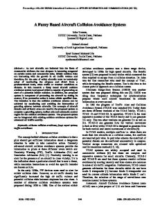
II. SYSTEM DESCRIPTION A. System Overview Due mainly to time constraints, the UCAS system has been designed to operate in the en-route portion of the flight
and does not consider the take-off and landing events. The system receives input data from an air traffic controller, ground controller, TCAS, and non-cooperative aircraft1. Input data includes, but it is not limited to, UAS flight data, separation services, and cooperative aircraft position and intent. Based on this information, UCAS then senses, detects, and avoids any airborne objects that enter possible collision ranges. The system is capable of evaluating the threat of a near midair collision (NMAC) and executes an appropriate avoidance maneuver. B. External Systems To define the boundaries of the system, an external systems diagram is presented (Fig. 1). The UCAS system interacts with four other major systems: separation services, operations monitor, cooperative target collision avoidance, and non-cooperative systems. If applicable to the airspace in which the UAS is flying, an Air Traffic Controller (ATC) provides separation services for the UAS carrying UCAS. A Ground Controller is responsible to monitor the UAS operation and assigns responsibilities when conflict occurs. The use of transponders allows the UAS to exchange data such as identification of the vehicle, flight plan, and intention with cooperative targets. The UCAS logic and sensors assist the UAS with its capabilities for sense, detect and avoid noncooperative objects.
ATC
AOC Ground Controller
TCAS
Fig. 1. External Systems Diagram.
C. Functional Architecture The UCAS system is composed of four key functions. These include sensing, detection, avoidance, and communication functions. Figure 2 shows a diagram with each function’s most important inputs, outputs and triggers. 1 Non-cooperative aircraft refers to any object not possessing systems that annunciate their position; contrary to cooperative objects equipped with transponders and/or systems such as TCAS and Automatic Dependent Surveillance Broadcast (ADS-B).
Whereas in most cases sense and detect are used interchangeably, with respect to UCAS the sensing function refers to the ability of the system to perceive some external stimuli while the detecting function is the means to uncover, discover, and manage imminent risks to the UAS. The avoidance function’s main role is to evade a collision with some perceived risk. The maneuvering of the UAS will be performed based on the scheduled flight plan along with the level of responsibility assigned by the ground controller. The communication function refers to the ability to notify external systems of appropriate events regarding the flight of a UAS equipped with UCAS.
issue is selected for further analysis and a likelihood assessment is performed on the safety issue. The likelihood of the safety issue is assessed in the absence of a mitigation strategy and then with a mitigation strategy applied to it. Finally, the alternatives analysis identifies and evaluates various configurations of the mitigation strategy. The configuration yielding the greatest benefit is recommended.
Fig. 4. Safety analysis methodology employed to analyze UAS safety.
A. Hazard Analysis The hazard analysis is used to identify and structure what could hypothetically go wrong with UAS operations. The hazard analysis consists of a Problematic Event List (PEL) and a Fault Tree. 1) Problematic Event List (PEL)
Fig. 2. Functional Architecture Diagram
D. Generic Physical Architecture The generic physical architecture for UCAS (Fig. 3) defines the hierarchy of physical components that encompass the system. The top-level components include a sensing component, a detecting component, an avoidance mechanism, and a communication component. However, for the purpose of the analysis that follows, the focus will be on the sensing component.
In order to begin analyzing the safety of the UAS, a problematic event list (PEL) was created. The list outlines all the foreseeable events known to affect the safety of the UAS. For each event, a severity level was assigned, categorizing the event. The table below illustrates the severity categories of events in ascending order. TABLE I SEVERITY CATEGORIES FOR PROBLEMATIC EVENTS
Fault Any deviation from the desired behavior of the system. Failure “The exposure to danger or harm”. Hazardous Event An event posing a major threat to the system or external systems. Catastrophic Event A catastrophic outcome resulting from an unmitigated hazardous event.
Fig. 3. UCAS Generic Physical Architecture
2) Fault Tree III. SAFETY ANALYSIS The UAS safety analysis was conducted to gain insight into the problems affecting UAS safety as well as what could be done to address these problems. The safety analysis consists of a multifaceted set of sub-analyses. The hazard analysis identifies and organizes what could go wrong with a UAS in operation. From the hazard analysis, a specific safety
The Fault Tree is a hierarchical structure built off the PEL. It could be considered as an ordered arrangement of the elements in the PEL illustrating cause and effect. It is created using a deductive, top-down approach beginning with the most severe problematic event.
Fig. 5. Flow diagram illustrating the typical cause and effect relationships between problematic events that provided the baseline for structuring the fault tree.
The scope of this safety analysis lies within analyzing a specific safety issue or branch of the entire fault tree. The branch of the fault tree that is examined is the occurrence of a near mid air collision (NMAC) operating under visual meteorological conditions (VMC).
performed. The simulated likelihood assessment used a Monte Carlo simulation model to estimate the likelihoods that a NMAC under VMC occurs both with and without UCAS. The analytic likelihood assessment estimated the likelihood of sensor failures using probability theory (developed in more detailed in Section V). The analytic approach was then further used to estimate the likelihood of NMACs under VMC considering both, sensor and logic failures. 1) Likelihood Assessment - Monte Carlo Simulation The basic simulation idea involves UAS and manned aircraft operating within an airspace region. A UAS is performing an operation within the airspace segment, with manned aircraft passing through the airspace. If a UAS gets too close (less than 500 feet) to another aircraft while performing its operation, a near mid air collision (NMAC) occurs. The following illustration provides a conceptual view of the simulation idea.
Fig. 6. Branch of the fault tree being analyzed. It includes the top level problematic event, NMAC under VMC.
B. Likelihood Assessment The objective of the likelihood assessment is to select and evaluate a specific safety issue coupled with a mitigation strategy. In an ideal case, the analysis effort would evaluate the entire fault tree by selecting the highest level problematic event, in this case Loss of Life. But due to time and resource constraints, only a lower level safety issue outlined in the fault tree was selected. Further analysis and investigation could be conducted in analyzing other safety issues specified by the fault tree. As specified in the previous section, the scoped safety issue being looked at is the occurrence of NMAC under VMC. The objective is to estimate the likelihood of this hazardous event without a mitigation strategy and compare it to the estimated likelihood the event occurs with the mitigation strategy. The UCAS system has been chosen as the mitigation strategy of analysis. Two types of likelihood estimation procedures were
Fig. 7. Generic illustration of the simulation paradigm
A realistic airspace segment affected by the collision avoidance problem of UAS was chosen and used as the fundamental baseline in making a valid business case. The following case study describes the background of the airspace segment of concern.
IV. CASE STUDY: THE ARIZONA BORDER CONTROL INITIATIVE (ABC) The U.S. has been faced with the problem of illegal immigrants sneaking into Arizona from Mexico. Not only are these immigrants migrating to the U.S. for a better place to live, but illegal narcotics are being smuggled into the U.S. through Arizona as well. The Department of Homeland Security consequently established the Arizona Border Control (ABC) Initiative to tackle this illegal inflow of drugs and immigrants to the U.S. The initiative involved assigning additional personnel and aviation resources to the Arizona border. Among the aviation resources are helicopters, fixed wing aircraft, and UAS.
The pressing UAS safety issue of collision avoidance has led the ABC initiative to restrict the airspace operating over the Arizona border. Temporary flight restrictions (TFR) have been placed over this segment of airspace to account for the deficiencies in UAS safety. This safety mitigation tactic becomes problematic, as TFR are temporary and not intended for long term usage. The vice president for the American Owners and Pilots Association (AOPA) says, “the use of 'temporary' large-scale flight restrictions for yearlong UAV operations is not appropriate. It is unacceptable to cordon off large areas of civilian airspace just because a UAV can't detect and avoid other aircraft.” [3]. He also voiced his opinion to the FAA, requesting that less restrictive alternatives be adopted. Ultimately, an alleviation of the TFR over the Arizona border is needed. If UAS are proven to be safe operating in this airspace segment without flight restrictions, a business case could be made substantiating the removal of TFR’s over the Arizona border. This will be accomplished through demonstrating safe collision avoidance ability of UAS in this airspace while operating with other aircraft flying through the airspace without restriction. A. Base Encounter Model The base encounter model provides an estimate of the probability of a near midair collision P(NMAC) without UCAS. The base encounter model simulates the Arizona border airspace with two UAS performing a border patrol operation. The model attempts to capture the essence of the Arizona border airspace without any operating restrictions. Various aircraft known to fly through the airspace segment are included in the model. The UAS follow a circular flight plan and remain within the airspace for the duration of the operation. For the entire length of the operation, the Euclidian straight line distance (1) between a UAS and manned aircraft is measured at every time step. Once the operation has completed, the minimum distance between any UAS and manned aircraft is recorded as output data. The Monte Carlo model is run for 10,000,000 hours and each operation yields a minimum miss distance output from which an empirical frequency distribution of minimum miss distances for each operation is constructed. The operation runs yielding miss distances within NMAC criteria are tallied and divided by the total number of operation runs (714,286) to determine the P(NMAC).
B. ABC Patrol Operation Assumptions The restricted airspace where the UAS border patrol is taking place spans a 300 nautical miles by 17 nautical miles region along the border of Arizona and Mexico. The temporary flight restriction (TFR) placed on the airspace entails reserving the airspace between 14,000-16,000 feet solely for the usage of the UAS. The ABC initiative commenced in the summer of 2004 with two Hermes 450 UAS performing the border patrol operation within the restricted airspace. As of fall 2005, the Predator-B UAS was implemented for border patrol usage.
Fig. 9. Entire region of the Arizona border airspace of concern.
Within this large region of airspace, it is difficult to capture the variety of aircraft as well as the flight schedules the aircraft would follow. To address this modeling issue, the following simulation strategy was adopted; the variety of aircraft (aircraft variation) and aircraft flight schedules are based off of active airports located within the restricted airspace. The airspace region that is modeled is bound by two active airports, Nogales International and Bisbee Douglas International which are separated by 64 nautical miles. Two Predator-B UAS are each performing border patrol in the vicinity of one of the two cities. A map is provided below illustrating the specific sub-segment of airspace chosen to be modeled.
Fig. 10. Segment of airspace modeled. Fig. 8. Base encounter model inputs and outputs
The following are other ABC assumptions that have been made: •
•
•
• •
•
•
Patrol
Operation
Aircraft variation and flight schedules are based off of the characteristic aircraft types known to operate at Nogales and Douglas International airports. The aircraft data for both airports is aggregated and used as the input data for the simulation model. A portion of the restricted Arizona border airspace is used. Airspace region is bound between the two airports and modeled as a rectangle with length (x) = 64 nautical miles, width (y) = 17 nautical miles. The operating altitude of aircraft in the model is not constrained to the altitude restriction assigned by the TFR. However, the UAS are modeled to operate within this altitude (14,000-16,000 feet) which is assumed to be the optimal operating altitude for border patrol. Two Predator-B UAS are assigned to border patrol in the vicinity of each airport. UAS carry out the border patrol operation using a circular flight path with a radius large enough to remain in the airspace. Aircraft can operate at any altitude within the airspace bounded by the altitude ceiling of the aircraft and the maximum height of the ground terrain of the airspace. This assumption was made because the operating altitude data of aircraft is difficult to obtain. Ground terrain's highest point is less than 500 feet. This assumption assigns the lowest operation altitude of any aircraft.
The following table lists the parameters’ values of the Arizona border that were used as input into the base encounter simulation. TABLE II ARIZONA BORDER INPUT DATA Airspace Parameters Airspace Length Airspace Width
Value
Arrival rate λ UAS Flight Plan
Aircraft Parameters Aircraft type Single engine aircraft Multi engine aircraft Military aircraft
UAV type Aircraft velocity Operating ceiling
2) Simulation Data The parameters that were developed and implemented in the simulation are provided in the table below. TABLE III BASE ENCOUNTER SIMULATION PARAMETERS
Simulation Parameters x position coordinate y position coordinate z position coordinate Heading angle θ left side of airspace right side of airspace top side of airspace bottom side of airspace Aircraft velocity Total operation run length Number of operations
Range UNIF(0,64) nautical miles UNIF(0,17) nautical miles UNIF(500,aircraft ceiling) feet 4 cases UNIF(3π/2,5π/2) UNIF(π/2,3π/2) UNIF(π,2π) UNIF(0,π) 98 - 220 knots 10,000,000 hours 107 / 14 = 714,286 operations
3) Simulation Equations • Miss Distance Calculation (Euclidean formula)
64 nautical miles 17 nautical miles
UAS Mission Paramaters Border Patrol Operation Length
• The aircraft operating within the airspace are at cruising altitude with a constant velocity and constant altitude. • The positions of aircraft are updated via linear motion equations. • Aircraft are modeled as point masses in the airspace. • The total operation run time is set to match the FAA target level of safety of 10-7 events/hr. of operation. This run length facilitates the benchmarking process of the analysis. • A near mid air collision (NMAC) is defined as the Euclidian straight line distance (1) between the point masses being less than 500 feet.
14 hours 100 aircraft/day Circular Orbit (radius = 8 nautical miles) Single, Multi, or Military Aircraft 73% 15% 12% Predator-B unique to each aircraft unique to each aircraft
1) Simulation Assumptions Provided below are some of the assumptions used in simplifying the reality of the border patrol operation to an approximation captured by the actual simulation model.
rto = ( xt − xo ) 2 + ( y t − y o ) 2 + ( z t − z o ) 2
(1)
where t refers to the threat aircraft and 0 to the UAS. • Aircraft Motion Update θ = angle at which an aircraft is heading (taken with respect to an imaginary Cartesian coordinate system about the aircraft). r = the radius of the circular orbit the UAS flight path follows. Aircraft: θn+1 = θn
θ n + ω * ∆t , x n +1 = xn + v cosθ * ∆t y n +1 = yn + v sin θ * ∆t
UAS: θn+1 =
z n +1 = Z n * ∆t
where
ω = v/r (2) (3) (4)
4) Figures of Merit 1) Additional Assumptions for UCAS Encounter Model The FAA safety level that has been set forth for general aviation manned aircraft is 10-7 events per hour of operation. To this point only preliminary runs were made (total number of operations runs of 142,858) yielding a number of NMAC of 3.4 x 10⁻⁶ events per hour of operation. Currently running, is a model with the following characteristics:
• •
•
7
• Total run time: 10 hours • Operation run length: 14 hours 7 • Number of operation runs = 10 ≈ 714,286 operations. 14 • NMAC ≡ any minimum miss distance < 500 feet. • Number of NMACs • P ( NMAC ) = # NMACS # Operations C. Encounter Model with Collision Avoidance The encounter model with collision avoidance provides an estimate of the P(NMAC) with UCAS logic. The UCAS encounter model is structurally the same. The UAS are now employed with an ability to avoid aircraft that might pose a threat leading to an NMAC. The Euclidian straight line distance between UAS and aircraft targets is measured as in the base encounter model. The UAS is now employed with the ability to sense the aircraft if the miss distance falls within its sensing range. For all the aircraft within the sensing range of the UAS, a preset avoidance distance threshold is compared to the miss distances of each aircraft. The aircraft that fall within the bound of the avoidance distance threshold are marked as aircraft that might need to be avoided. A threat determination algorithm is used to decide which of the flagged aircraft poses the biggest threat. The collision avoidance maneuvering algorithm is then performed by the UAS away from the target posing the biggest threat. The minimum miss distance for each operation run is recorded similarly to the base encounter model.
•
Manned aircraft do not provide any avoidance mechanism. The P(sensor failure) = 0 for the simulation. Sensor failures are taken into account in the analytic likelihood assessment. P(NMAC | logic) is the quantification of the likelihood that a logic failure occurs as is applied to the fault tree. Additional parameters include: turn rate and climb rate (for collision avoidance maneuvering) and sensing range (for sensing capability of UCAS).
2) Figures of Merit It is expected that the results of the UCAS model will yield a frequency distribution of miss distances with a considerably higher mean as well as a lower P(NMAC) in comparison to the base encounter model. The P(NMAC|logic) generated through the UCAS encounter model will be an integral likelihood in quantifying the safety of the UAS, adding additional consideration for sensor failures; a problematic event not taken into account here.
V. ANALYTIC LIKELIHOOD ASSESSMENT Sensor failure has not been taken into account in the simulated probability estimate. An analytical approach has been adopted to take sensor failures into account. Through this approach, the P(NMAC | VMC) is estimated combining the failures of sensors and logic. Classic probability theory has been used to combine the probabilities of constituent events involved in a sensor failure. TABLE IV SYMBOL DESCRIPTION
Event Sensor Operational Sensor Failure Noise Failure Sensor Malfunction False Alarms Missed Alerts
Symbol SO SF NF SM FA MA
P ( SF ) = P ( NF U SM ) P ( SF ) = P ( NF ) + P ( SM ) − P ( NF I SM )
(5) (6)
Because a noise failure is assumed to be independent of a sensor malfunction,
P ( NF I SM ) = P( NF ) * P ( SM ) . Fig. 11. Encounter model with mitigation strategy inputs and outputs
(7)
Substituting (7) into (6),
P ( SF ) = P ( NF ) + P ( SM ) − [ P ( NF ) P( SM )] .
(8)
The probability of a noise failure is based off either a false alarm OR a missed alert occurring.
P ( NF ) = P ( FA U MA)
(9)
False alarms and missed alerts are mutually exclusive events. Therefore,
P ( NF ) = P ( FA) + P ( MA)
the scope of the safety analysis. The P(NMAC|VMC) quantifies the safety in two instances. In the first instance the value is used in its comparison to the FAA target level of safety of 10-7 events/hr. of operation. Secondly, the P(NMAC|VMC) is divided by the P(NMAC) taken from the base encounter simulation to form a risk ratio. This ratio expresses the marginal safety improvement experienced through the implementation of the UCAS mitigation strategy.
(10)
Plugging (10) into (8) describes the P(Sensor Failure).
RiskRatio =
P( NMAC | VMC ) P ( NMAC | Mitigation ) =