International Journal of Applied Information Systems (IJAIS) – ISSN : 2249-0868 Foundation of Computer Science FCS, New York, USA Volume 2– No.3, May 2012 – www.ijais.org
River Change Detection and Bank Erosion Identification using Topographical and Remote Sensing Data Sainath P. Aher
Shashikant I. Bairagi
Pragati P. Deshmukh
Ravindra D. Gaikwad
Dept of Geography, S. N. Arts, D. J. M. Commerce, B. N. S. Science College, Sangamner, DistAhmadnagar (M.S.)
Dept of Geography, S. N. Arts, D. J. M. Commerce, B. N. S. Science College, Sangamner, DistAhmadnagar (M.S.)
Dept of Geography, S. N. Arts, D. J. M. Commerce, B. N. S. Science College, Sangamner, DistAhmadnagar (M.S.)
Dept of Geography, S. N. Arts, D. J. M. Commerce, B. N. S. Science College, Sangamner, DistAhmadnagar (M.S.)
ABSTRACT There are continuous changes upon earth surface by a variety of natural and anthropological agent‟s activities. These agents cut, carry, away and deposit the materials from land surface. Running water has higher capacity of erosion than the other geomorphologic agents. The present research work related to „Pravara River‟ which channel is continuously changing due to geomorphic, climatic agents and human activities influence in the surrounded region of Present River. This changes identification is the main objective of paper with constructive suggestions for control the bank erosion and shifting of Pravara River. An attempt has been made here, to apparatus the GIS and RS techniques for river change detection using traditional to advance geographical data sources. The advances Remote Sensing data and Topographical data are to be implementing for obtaining 35 years changes results in river stream. The comparatively result explains the 35 years changes in the river bank due to various natural and manmade activities like flood, water velocity, sand excavation, removal the vegetation cover and fertile soil excavation for the various proposes of local surrounded region‟s people.
Keywords: Erosion, Change Detection, Remote Sensing, GIS.
1. INTRODUCTION There is an unremitting transformation of landforms on the earth surface owing to various atmospheric, morphological and anthropological agents. The denudation processes on the earth surface like weathering and erosion also responsible for changes in landform. This change occur in various field like Fluvial, Glacial, Arid, Wind, Coastal and karst morphology because of dynamic phenomena of earth. River is important part of human being which is continually changing from its evolutions. The cycle of river starting after the upliftment of the land mass (W.M Davis). Generally, this cycle passes through youthful, mature and old stages of river. The gradient or slope, water volume, water velocity and nature of river are responsible perimeter for changing the rivers shape and size. There is growing trend in research community to apply the various techniques for human being's problems identification as far as its solutions. GIS and RS are important task of recent century which can help for identifying river changes and bank erosions situations. This is computer oriented techniques which is performing the analysis along with influential results. In the field of Hydrology, geomorphology and geology data obtained from their actual surveys as input in their mathematical modeling. Convections techniques is time
consumed and finding less accuracy at the same time repeated measurements for identifies the change of channel. Advance Remote sensing data combined with digital data to extract information and obtain specific measurement. Throughout this extracted vector based information channel migration of Pravara River identified. The combination of scanned analog and digital data with time sequential data making is the interactive base map which can implement for multipurpose planning and related application. Throughout the present research work analyses here, how the river channel is shifting form actual base channel due to various reasons? Due to the various natural and man-made causes river changing its base stream. For this change detection identification recent advance techniques is powerful which can help for explain the micro analysis of study area with proper results and evidence. Traditional surveying problems, these problems could be minimized by using advance remote sensing database. Throughout the various geographical databases (Toposheet and Google image) Pravara river channel changes are proved near Sangamner city with the help of combination of traditional and advance RS data sources.
2. STUDY AREA Present Pravara River flowing into northern part of Ahemadnagar district into Akole, Sangamner, Shrirampur and Nevase Tahsil. The source of river near the Ratanwadi village in Akole Tahsil (Western Maharashtra). The total length of Pravara River near about 234 K.M and it is the one of the part of Godavari Basin. Out of to overall region some of the middle area (mature stage) is selected for the purpose of applying GIS and RS teachings to identify the changes in River channel. This area near the Sangamner city‟s southern side which is small scales study giving the directions of large scale study in correlated fluvial morphology. The present area belongs to Deccan plateau of peninsular India which is the part of „The western Deccan volcanic province‟. Khadala and Poladpur formations situated close to the Western Ghats escarpment which has moderate relief and is drained by tributaries of the Pravara River. The basalt flows are nearly flat-lying and mainly belong to the Thakurvadi Formation of the Kalsubai Subgroup (Khadri et al. 1988; Subbarao and Hooper 1988). Extensive colluvioalluvial deposits (locally up to 30 m thick) of the late Quaternary Pravara Fm. (Bondre 1999) overlie the basalts along the Pravara River and its tributaries. Patches of these sediments are also found along the Pravara River. The basalt flows are classic compound pahoehoe, ranging in thickness from few tens of meters to well over 50 m, and are made up of
1
International Journal of Applied Information Systems (IJAIS) – ISSN : 2249-0868 Foundation of Computer Science FCS, New York, USA Volume 2– No.3, May 2012 – www.ijais.org individual flow lobes ranging in thickness from a few cm to 20 m (Bondre et al. 2000, 2004). (See Fig. 1)
topographical river and Google maps river come on same scale due to WGS84 (World Geodetic System) projections. The river geometrical information extracted throughout digitization procedure on separated layer. Lastly, this layer is superimposed on one another for change detection and bank erosion mapping while changes of channel are mapped and analysis the bank erosion which is useful for various fluvial geomorphologic planning sector. Following methodology is adapted here. (See Chart: 1).
Fig.1: Location Map of Study area
3. AIMS AND OBJECTIVE: The biotic and a biotic life are directly and indirectly attached with river environment that‟s why a normal scale changes starting to modifies local environmental characteristics. For identifying these situations some aims and objective is settling here. Primitively put of the aims is to understanding overall river situations from source region to confluence region of Pravara River. To identifies bank erosion of river by various base map while the River stream change detection over to various data source and using software (GIS). To Infar the causes of bank erosion and stream change, Finding the impact of bank erosion as well as channel shifting on local region, Mapping the river shifting from base line of river to both directions, To identify the spot where the highest bank erosion as far as maximum soil loss, Creations of river changes base map and its analysis, Future prediction of high bank erosion as well as river shifting, To infer River stream change or shifting, To identified Risk Zone where the loss of soil is higher due to erosion, To explain the River bank erosion, Analysis the Risk Zone area and erosion area etc. aims and intention locate in front of study.
Chart: 1
5. TOPOGRAPHICAL DATA, REMOTE SENSING DATA AND GIS TECHNIQUES: Topographical map is on a sufficiently large Scale to enable individual features shown on the map to be identified on the ground by bonier shape and position. Study area's topomaps are 1:50,000 Series map which is served in 1974-75 means this year River situations are shown in the 47/I/2 Toposheet (See Fig. 2).
4. Methodology: The conventional analogue and advance digital data of Pravara River are used for the study. The topographical map belong to 47/I/2 series of Survey of India which is prepared in 1974 after the manual surveying of Pravara river and adjacent regions. Similarly, Google maps are obtained from open source „Google Earth‟ software where the overall world‟s spatial images are added, which is captured by remote sensing of spatial surface and further, images processes for the purpose of visual interpretations. From this software 2009‟s images are cropped at 600 m. resolution. The SRTM (Shutter Radar Topography Mission) data are also used for understanding the gradient and relating physiographic information. The SRTM is an international research effort that obtained digital elevation model for the earth surface. It is joint project to national (NOA) and the National Aeronautics and space Administration to map the 3 dimensional earth space with the help of space born imaging Radar (STR-C) and dual X-bank synthetic Aperture Radar (X-SAR). This data are downloading from http://www.srtm.csi.cgiar.org website for regarding utilizations in study. Present regions toposheet rectified in GIS software (Global Mapper8). At the same time cropped Google images are also rectified from toposheet. Owing to rectification both the
Fig. 2: Toposheet and Google Image Data Sources Remote sensing is the one of the techniques in which the capturing of spatial information without physical contact with spatial object of earth surface. Data are collected with the help of satellite which can implement in various planning
2
International Journal of Applied Information Systems (IJAIS) – ISSN : 2249-0868 Foundation of Computer Science FCS, New York, USA Volume 2– No.3, May 2012 – www.ijais.org filed according to set of need. Geographical information systems belong to software, hardware, data, people and method which can store, retrieve, manipulate and analysis of the vast data with the help of computer and software. Throughout the multiple data sources and GIS techniques there is receiving the proper results of river shifting and bank erosion. The base map prepared by software over to topographical and remote sensing data analysis the accuracy of river changing.
river is mapped by vecterisions in GIS and throughout the field work in study area. (See Fig.3, Table 1&2).
6. BANK EROSION MAPPING: The study is carried out with the help of RS data, topographic sheet (47/I/2) and the data collected from the field. All this data were individually processed and analyzed in a GIS environment. Here are prepared the bank erosion's thematic maps. Toposheet data showing the 1974-75 situation of Pravara River while the Remote Sensing data (Google image) showing the 2009‟s situations of river. When this two database are overlay on one another along with WGS84 projections in GIS that time finding the bank channel shifting of Pravara River from actual positions. This shifted part of
Fig. 3: River Channel shifting near Dhandarfal village in Sangamner Tahsil.
Table 1: Mapped bank erosion with shifted direction near Dhandarfal (Sangamner Tahsil-2009) Left Right Left Right Location bank bank Location bank bank Direction Direction Direction Direction No. shift shift No. shift shift (M) (M) (M) (M) 1 46.1 Left 69.8 Left 14 69 Right 0.697 Left 2 91.3 Right 76.2 Right 15 23.3 Right 21.3 Left 3 33.2 Right 62.5 Left 16 52.3 Left 29.5 Left 4 89.1 Right 50.9 Left 17 26.8 Left 29.2 Left 5 36.2 Right 44.7 Left 18 71.5 Right 4.16 Left 6 20.1 Right 42.8 Left 19 32.1 Left 4.43 Left 7 41.4 Right 65.8 Left 20 10.3 Left 75.9 Left 8 20.5 Left 92.3 Left 21 39.4 Left 107 Left 9 44.3 Left 113 Left 22 51.7 Left 118 Left 10 18.3 Left 64.2 Left 23 44.3 Left 123 Left 11 5.37 Left 51.9 Left 24 52.9 Left 132 Left 12 13.6 Left 85.5 Left 25 41.3 Left 113 Left 13 22.6 Right 43.7 Left Table 2: Metadata of Bank Erosion Left Right Remark Bank Bankm Min. shifting 5.37 m 0.697 Location
11
14
Direction Max. shifting
Left 91.3 m
Left 132 m
Location Direction
2 Right
24 Left
Average shifting
39.8788 m
64.85948 m
7. RIVER
CHANNEL
CHANGE
DETECTION Present study region topomaps shows the Pravara Rivers situation in 1974-75 while the advance remote sensing data (Google Image) pertaining the study region showing the recent conditions. This all database vectorision in GIS software clear the changing situation of river form actual flow line. Both the Raster data base (Topomap: 1974-75 and Google image: 2009) vecterision on different layer over unique scale and projections shows the changes in stream which is called here 'River shifting‟ from actual baseline. This change is detected with the help of various data source and field work which is shown by mapping calculations and prepared thematic base map with quantitative data generations. (See Fig. 4)
3
International Journal of Applied Information Systems (IJAIS) – ISSN : 2249-0868 Foundation of Computer Science FCS, New York, USA Volume 2– No.3, May 2012 – www.ijais.org
Fig.4: Pravara River Change detection by superimpose of various database (2009) It has universal truth that where the curvature of river higher, there is higher erosion of fertile soil due to active water forces while the deficiency of vegetation cover on curvature of bank. Especially 10 risk zones are identified in study area which has show rapidly erosion and fertile soil loss due to water velocity where the curvature of river and less vegetation cover is observed. This situation also identified trough the field visit and sampling photograph. The results are obtained, that the human activities also accountable for rapidly bank erosion like sand excavation, level of agriculture in river stream and vegetation removal etc.
8. CAUSAL
AND CONTRIBUTING FACTORS OF RIVER BANK EROSION
On the earth surface there are operating dynamic earth forces which is changing the land forms and related morphology. The changes in fluvial morphology finding rapidly as compare to arid, glacier, karst and coastal morphology. Pravara River flowing over to Deccan plateau as far as it is seasonal river. In the period of monsoon in India, especially in the month June, July maximum year it is facing flood activity. Form Bhandardara dam (constructed on Pravara River near Kalsubai pick in Akole Tahsils western part) renounces the rotations on specific time. Most of the river flowing into passage of plain region which has the high capabilities of erosion due to fertile and loam structures of soil. Erosion is affected by many natural factors such as rainfall, vegetation cover, river bank soil stability, river sediment, bedrock characteristics, relief-slope characteristics, and hydraulic conditions. Human activities occurring also which are thought to exacerbate erosion and sedimentation in the Pravara River include: (i) clearing of vegetation along the river banks; (ii) construction in river bed near the located important city‟s; (iii) sand, gravel and fertile soil extraction; (iv) broad-scale deforestation (v) Large dam construction; and (vi) sand, Pebbles, coarse and fine grain sand are collected from the channel bed for construction purpose and brick industry. Likewise, The water velocity, Time span in rotation of river, human encroachment-land leveling in river, natural
obstacles e.g. Rocks, human obstacles-pollution material like garbage, slopes of the river, revulsion, relatively unstable banks, the concentration of rainfall in different time periods etc. are the another natural and manmade factor which is responsible for bank erosion of Pravara River.
9. IMPACT OF BANK EROSION AND SHIFTING CHANNEL Human being and River's relationship has great historical prospective, evenly human civilization also developed on the bank of rivers. Thus, the human interaction along with river for multipurpose which can welfare of organic life. Almost, biotic factors directly and indirectly depend on the river, that‟s why occurrence of change in river suddenly changing the attached environment with rivers. Some of the momentous impact highlighted during the study. This are (1) Removing the fertile soil and plants species of the bank of river. (2) River bank erosion creates difficulties for the inhabitants of the vegetation. (3) Degradation of fertile soil which has higher capacity of productivity and efficiency. (4) Water level decreases due to deepening of bed. (5) Unuseful sand growing (deposition) in opposite direction of erosion. (6) Flood condition- it is one of environmental hazard. (7) Change in river morphology and geometry. (8) Some Settlement diverse or shifted due to higher bank cutting. (9) Owing to removing of valuable species most of the fauna species divorce. (10) Impact upon human life as well as its various activities. (11) Meandering of River due to changing the stream flow and geometry of river. (12) Standing crop loss during the flood period. (13) Changing physical characteristic of river and surrounded environment.
10. MITIGATION MEASURES Present study area belongs to plain topography where the maximum people community consisting with agriculture and supplementary activity due to availability of fertile soil and potential water source. Although there is various changes in river channel owing to bank erosion which is responsible for
4
International Journal of Applied Information Systems (IJAIS) – ISSN : 2249-0868 Foundation of Computer Science FCS, New York, USA Volume 2– No.3, May 2012 – www.ijais.org fertile soil loss, vegetation removal and parallel effect, but there is need to control that thing by some solutions. To prevent future damages we can prepare the Embankment, revetment, the wire creating spur will be a useful measure to reduce the flow velocity. Scientific River training management, Awareness generations in local peoples for prevent the farm leveling near the river bank as well as is required to reduce the tendency of deforestation, agricultural practices in river bed etc. Some of the Engineering Solutions can be also implementing for problems reductions which are explain here. Bank revetment is considered to be the best available engineering response to the serious river bank erosion occurring along the Pravara River. Although alternative bank protection methods are currently being researched in worldwide but potential of special grass planting methods is also useful for minimize that impact and stabilizing river banks. The wall construction will also useful where the high curvature and sensitive spot.
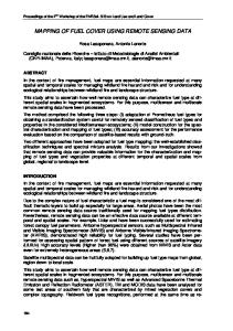
11. CONCLUSION AND DISCUSSION Thus, it can be stated beyond doubt that GIS can be a very efficient tool in the process of identification and mapping of river changes and bank erosion. In this case study it has become clear that the Remote Sensing digital data can gives the better results than the conventional methods. The channel of Pravara River shifted to the both bank side, which results obtained by super imposing of topographical maps and Google map‟s of Pravara River. Throughout this case study showing that river stream changes owing to various natural and manmade phenomena. It has done with various analog and advance digital data study at micro level. Finally, it can be said that in spite of some changes, topographical remote sensing data and GIS studies can help to change detection and other field of fluvial sciences (Fig.5). This paper demonstrate the application of recent GIS and RS techniques for bank erosion and change detection mapping as well as present the capabilities of RS data with GIS analysis for river study and related various assessment.
Fig.5: Channel migration near Sangamner city during 35 year.
12. OBSERVATIONS, IDENTIFICATION AND RESULTS An attempt has been made in this paper to implement the analog, modern digital and field survey data sources for detection of river bank erosion and channel shifting. With the help of this year wise data base finding the river channel shifting due to bank erosion. Field work also helps for probing
the river shifting evidences in study area. Vector database creation from Topographical and Google maps of study area showed the various time real position of river. This mapping proved that the Pravara River is shifted from its actual baseline channel. In the area of curvature discover the high bank erosion, which resulting the meandering stage of river. At the various curvatures spot of river finding very high bank erosion (Fig. 6 & Table 3).
5
International Journal of Applied Information Systems (IJAIS) – ISSN : 2249-0868 Foundation of Computer Science FCS, New York, USA Volume 2– No.3, May 2012 – www.ijais.org
Fig.6: Coding of Risk Zones and its Attribute Data
Risk Zone (Polygon ID)
Loss Area (sq.k.m.)
Risk Zone (Polygon ID)
Loss Area (sq.k.m.)
A 0.0135 K 0.0036 B 0.016 L 0.00476 C 0.00307 M 0.00853 D 0.0084 N 0.0122 E 0.00698 O 0.00391 F 0.00635 P 0.00591 G 0.00731 Q 0.0049 H 0.00896 R 0.00474 I 0.0102 S 0.00678 J 0.00546 T 0.0094 When the frequency of flood, intensity of water volume and water velocity is high that time finding the high bank erosion
and shifting trend is also high. 2) When the bank structure made by soft loam structure soil and soft rock that time river erode capacity is higher. 3) Stream erodes their valleys‟ until the gradual condition is achieved. 4) When the vertical erosion high, that time bank erosion finding the low. Which resulting formation of „v‟ shaped valley. 5) Gradient factor determine the erosion ratio, when the gradient is high that time bank erosion is less due to vertical cutting and high water velocity. 6) At the curvature of river enormous high erosion as compare to other bank‟s of river because of water force directly impact upon these curvature. 7) When the absence of vegetation cover, grasses, hard rocks on the river bank there is maximum bank cutting. 8) Present river accruing the meandering position due to shifting of channel. (See Photos)
6
International Journal of Applied Information Systems (IJAIS) – ISSN : 2249-0868 Foundation of Computer Science FCS, New York, USA Volume 2– No.3, May 2012 – www.ijais.org
13. ACKNOWLEDGEMENT We are very thankful to our respected Chairman Dr. Sanjay Malpani and Principal Dr. K. K. Deshmukh, Sangamner College, Sangamner for always positive approach concerning new innovation. We would also thanks to Department staff Mr. Navale Sanjay, Mr. Sandip Deshmukh, and Mr. Bhrat Bhagavat and Navnath Talpe for providing the necessary facilities, surveying equipments for the data collection and surveying in the field. Collages for their timely help during this research study.
14. REFERENCES [1] Joseph, George (2007), Fundamental of Remote Sensing, 2nd edition, Published by-University Press (India) Private Ltd. Hyderabad -500 029, [2] Khan, M. A. Watershed management for sustainable agriculture, published by Agrobios (India) Jodhapur – 2002, p.p. 13-19.
[4] Singh, Savindra Physical Geography, Prayag Pustak Bhawan, Allahabad: 2009, p.p. 215-230 & p.p. 249-265. [5] Khullar, D.R. India A comprehensive Geography, Kalyani Publishers, New Delhi – 2009, p.p. 86-91. [6] Kale, Vishvas S 2009, Research paper- “Identification and mapping of Geologic lineament in the Kaveri basin from SRTM-DEM data and satellite images”, [7] Reddy, M. Anji (2006), Remote sensing an d Geographical information System, 3rd edition,BSP Publications, Hydrabad-500095 (A.P.) [8] Bondre, N. R., Hart, W. K. and Sheth, H. C., Research paper, (Department of Geology, Miami University, Oxford, Ohio). Geology and Geochemistry of the Sangamner Mafic Dike Swarm, Western Deccan Volcanic Province, India: Implications for Regional Stratigraphy.
[3] Panda, B.C. (2006), Remote sensing principles and Application, published by Vinod Vasishtha for Viva Book Private ltd. N. Delhi-110 002.
7