REPORT SUMMARY Integrated Feasibility Report and Environmental Impact Statement Coastal Storm Damage Reduction Surf City and North Topsail Beach, North Carolina Feasibility Scoping Meeting: N/A Alternative Formulation Briefing: Dec. 2006 AFB Guidance Memorandum: Jan. 2007 Draft Report Guidance Memorandum: July 2010 Division Engineer Transmittal: July 2010 CWRB Briefing: Aug 2010 30-Day S&A Review Start: TBD 30-Dat S&A Review End: TBD FEIS filed with EPA: TBD STUDY INFORMATION Study Authority: Coastal storm damage reduction for Surf City and North Topsail Beach were studied by the Corps as part of the West Onslow Beach and New River Inlet general investigation study from 1992, and was found not to be economically feasible. However, following a series of hurricanes that damaged Topsail Island between 1996 and 1999, interest in a coastal storm damage reduction project was renewed. This feasibility study is in response to the two following resolutions adopted February 16, 2000, and April 11, 2000, respectively: •
Resolved by the Committee on Transportation and Infrastructure of the United States House of Representatives, That the Secretary of the Army is requested to review the report of the Chief of Engineers on West Onslow Beach and New River Inlet, North Carolina, published as House Document 393, 102nd Congress, 2nd Session, dated September 23, 1992, and other pertinent reports, to determine whether any modifications of the recommendations contained therein are advisable at the present time in the interest of shore protection and related purposes for Surf City, North Carolina.
•
Resolved by the Committee on Transportation and Infrastructure of the United States House of Representatives, That the Secretary of the Army is requested to review the report of the Chief of Engineers on West Onslow Beach and New River Inlet, North Carolina, published as House Document 393, 102nd Congress, 2nd Session, dated September 23, 1992, and other pertinent reports, to determine whether any modifications of the recommendations contained therein are advisable at the present time in the interest of shore protection and related purposes for North Topsail Beach, North Carolina.
Study Sponsors: The study sponsors are the Town of Surf City and the Town of North Topsail Beach
1
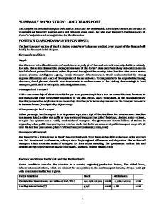
Study Area: The study area encompasses 17 miles of shoreline extending from the Topsail Beach and Surf City town limits to the northern end of Topsail Island, and is located in the North Carolina 3rd and 7th Congressional district. The study area and the limits of the proposed project are depicted in Figure 1.
Figure 1. Location of Surf City/North Topsail Beach study area and project limits. 2
Study Purpose and Scope: The feasibility report and environmental impact statement (FEIS) is a final response to the study authority. The purpose of the study is to provide coastal storm damage reduction benefits in the study area. The scope of the study consists of the analysis of measures and plans in order to select the plan with the highest net benefits, or determine that no plan of improvement is justified under current planning criteria and policies. Prior Reports and Existing Water Projects: The USACE has conducted a number of prior studies regarding the Topsail Island area and has prepared a number of related engineering, planning, and environmental reports. These studies have addressed coastal storm damage reduction as well as navigation needs. Reports particularly pertinent to the present study are listed below. Coastal Storm Damage Reduction •
House Document No. 480, 89th Congress, “Topsail Beach and Surf City, North Carolina.” This report, approved by Congress in 1966, presents the results of an investigation of Topsail Island conducted during the period 1963 – 1965 as part of a comprehensive study of shore protection needs for the segment of the North Carolina coast extending between Bogue and Moore Inlets.
•
House Document No. 393, 102nd Congress, 2nd Session, “West Onslow Beach and New River Inlet, North Carolina.” This report (HD 393/102/2) was conducted pursuant to four congressional resolutions adopted between 1970 and 1979. The resolutions addressed beaches, channels and inlets in the greater vicinity of Topsail Island.
Navigation •
House Document No. 450, 69th Congress, “Inland Waterway, Beaufort – Cape Fear River.” This house document, approved by Congress in 1927, authorized construction of the AIWW from Beaufort to the Cape Fear River, with dimensions of 12 ft. deep by 90 ft. wide.
•
House Document No. 421, 80th Congress, “Inland Waterway from Beaufort to Jacksonville, NC and New River to Jacksonville.” This house document, approved by Congress in 1948, authorized construction of a 12-foot deep by 90-foot wide channel in New River. However, the project was deferred for restudy and has not been constructed.
•
House Document No. 691, 75th Congress, “Channel to New River Inlet.” This house document, approved by Congress June 20, 1938, authorized construction of a 6-foot deep by 90-foot wide channel from the AIWW through New River Inlet to the Atlantic Ocean.
•
“Detailed Project Report on Improvement of Navigation, New Topsail Inlet and Connecting Channels.” This July 1965 report, approved by the Chief of Engineers April 7, 1966, authorized construction of a channel 8 ft. deep by 150 ft. wide through New Topsail Inlet.
3
•
“Detailed Project Report on Improvement of Navigation, New River Inlet, December 1987.” This report by the Wilmington District addresses that portion of the study authority concerning navigation at New River Inlet.
There are no other existing Federal coastal storm damage reduction projects in the study area. However, a General Reevaluation Report (GRR) for Topsail Beach (formally known as the West Onslow and New River Inlet GRR) was completed in 2008 and the Record of Decision was issued in April, 2010. The report proposes a berm and dune construction plan along approximately 5 miles of shoreline in the town of Topsail Beach. A number of Federal navigation projects are located in the study area; these are the Atlantic Intracoastal Waterway, New Topsail Inlet, and New River Inlet. Federal Interest: There is a Federal interest in the study, based on national economic development (NED) benefits derived from coastal storm damage reduction. STUDY OBJECTIVES Problems and Opportunities: The main public concerns identified in the study area are economic losses resulting from (1) damages to structures and their contents due to hurricane and storm activity, and (2) the loss of beachfront land due to progressive shoreline erosion. In addition, periods of severe shoreline recession have adversely affected nesting habitat for endangered and threatened sea turtles. There are opportunities to reduce coastal storm damages through either structural or non-structural measures; these measures could also incidentally provide benefits to threatened and endangered species. Planning Objectives: Over a 50 year project life, provide coastal storm damage reduction (as measured by increases in NED benefits) within 17 miles of shoreline in Surf City and North Topsail Beach, while minimizing or avoiding impacts to natural resources. Planning Constraints: The planning process is subject to the limitations imposed by the following constraints: A) Geographic limits of the study authority but including the affected area of the environment (such as offshore borrow sources). B) Applicable Federal and State laws. C) Current limits of knowledge, information, and predictive ability. D) The Coastal Barrier Resources Act (CBRA) zone in North Topsail Beach will be excluded from any proposed Federal project. ALTERNATIVES Plan Formulation Rationale: The study used a multi-step screening process to winnow down the number of potential alternative plans and come to a final array of alternatives. Initially, a variety of non-structural and structural alternatives were considered. Management Measures and Alternative Plans: Initial measures considered were both nonstructural (regulatory measures, retreat, relocation, and demolition) and structural (beachfill, 4
breakwaters, seawalls, and groins). Based on economic reasons and/or the ability of each of the measures to address the planning objectives, only the beachfill alternatives were carried forward into the final array of alternatives. Final Array of Alternatives: The final array of alternatives consisted of beach fill plans consisting of a 50 ft wide berm and either an 11,13,14,15,16, or 17 ft high dune. Additionally, a 25 ft berm with a 15 ft dune, a 75 ft wide berm with a 15 ft dune, as well as a no-action alternative were considered in the final array of alternatives. Comparison of Alternatives: The no-action alternative does not meet the objective of reducing coastal storm damages in the study area. The primary consideration in comparing the final array of dune and berm alternatives was their difference in net NED benefits. The key areas of risk and uncertainty regarding the comparison of these alternatives are in the area of economics and the predicted rate of sea level rise. Economic risk is explicitly incorporated into the GRANDUC model that was used to calculate benefits from the final array of alternatives. The historical rate of sea-level rise was used to determine benefits, however, low, medium, and high rates of sea-level rise were used to perform a sensitivity analysis on the recommended plan. Key Assumptions: The key assumptions made for this study are that the present physical and social trends will continue into the 50-year project life. We assume that damaging storms will continue to occur with comparable strength and frequency as have occurred in the past. The demand for vacation and permanent homes at the beach will result in new structures being built on any suitable remaining property and existing structures rebuilt after being destroyed by storms. The replacement structures will have to conform with property line and ocean front setback restrictions, with minimum Federal Flood Insurance elevations, and with new and stronger building codes, which will result in more damage-resistant structures. Key assumptions regarding beach modifications are that, other than reshaping of the dune and beach after storms, no other major beach nourishment project in the study area will be constructed by any non-Federal government due to the limited resources of the community. Some minor beach renourishment may be accomplished with local funding or after declared disasters when FEMA funding is available. These minor projects will not significantly alter the feasibility of a major Federal shore protection project. Recommended Plan: The recommended plan is the NED plan, referred to as alternative 1550. There is no locally preferred plan. Table 1 shows the features of the recommended plan:
5
Dune, topwidth, Dune, elevation, NGVD Dune, landward slope Dune, seaward slope Berm, width Berm, elevation, NGVD Berm, seaward slope Dune and berm fill, length North transition section, length (if required) South transition section, length (if required) Total Length Volume, initial, borrow CY Volume, renourishment, average, borrow CY Renourishment interval Borrow source Table 1. Features of the recommended plan.
25 feet 15 feet 5H:1V 10H:1V 50 feet 7 feet 15H:1V 52,150 feet Variable Variable 52,150 feet 11,855,000 2,642,225 6 years Off shore
Systems / Watershed Context: The report describes the cumulative environmental effects that could occur with the implementation of this project in addition to other potential federal and non-federal projects in the area. The study was coordinated and cooperated with the USFWS, NMFS, NC Dept for Archives and History, NC Wildlife Resources Commission, and the Mineral Management Service. The Mineral Management Service is a formal cooperating agency on the study. Environmental Operating Principles: The recommended plan was developed in a manner that is consistent with the EOP. Construction of the recommended plan would incorporate all reasonable measures for minimizing the impacts to the environment. Additionally, the recommended plan would provide incidental benefits to habitat for threatened and endangered species. Peer Review: The study has undergone Agency Technical Review (ATR) of the draft report in March, 2009 and of the final report in June, 2010. All Agency Technical Review comments were resolved. An Independent External Peer Review (IEPR) was also conducted on the draft version of the report in February, 2010 and all IEPR comments were also resolved. EXPECTED PROJECT PERFORMANCE Project Costs: Project costs are reported at October 2010 price levels and the FY2010 interest rate of 4.375%. The Total Project Costs are $127,973,000 for Initial Construction, and $215,525,000 total cost for 7 renourishments.
6
Renourishments (Total) Construction Item Initial $0 Lands & Damages $5,432,000 $205,826,000 Beach Replenishment $117,369,000 $6,035,000 Engineering & Design $3,188,000 $3,664,000 Construction Management $1,984,000 Total Project Construction Costs $127,973,000 $215,525,000 Table 2. Surf City/North Topsail Beach, NC, Project Costs , Oct 2010 price levels. Equivalent Annual Costs and Benefits: Annual costs and benefits are reported at October 2008 price levels and the FY2010 interest rate of 4.375%. Tables 3 and 4 contain information as of October 2008 on Total First Cost, Total Investment Cost, and Annual Costs. As of October 2008 the Interest During Construction is estimated at $10,120,000 for the Recommended Plan resulting in Total Investment Costs of $133,255,000. The Total Annual Cost at October 2008 levels is $11,180,000. Table 3. Surf City/ North Topsail Beach, NC, Investment Costs, October 2008 levels Item Amount Total First Cost $123,135,000 Interest During Construction $10,120,000 Total Investment Cost $133,255,000
7
Table 4. Surf City/ North Topsail Beach, NC, Annual Costs, October 2008 levels. Present value is discounted to FY2014. ITEM
YEAR
AMOUNT
PRESENT VALUE, 2014
Total Investment Cost
2014
$133,255,000
$133,255,000
Renourishment Renourishment Renourishment Renourishment Renourishment Renourishment Renourishment
2020 2026 2032 2038 2044 2050 2056
$20,872,000 $29,424,000 $29,424,000 $29,424,000 $29,424,000 $29,424,000 $39,200,000
$16,143,000 $17,601,000 $13,613,000 $10,529,000 $8,143,000 $6,298,000 $8,639,000
Total Investment Cost, Present Value
$214,221,000
Annual Costs Interest and Amortization @ 4-3/8% Investment Renourishment
$10,620,000 $6,606,000 $4,014,000
Monitoring
$508,000
OMRR&R
$52,000
Total Annual Cost
$11,180,000
Average Annual Benefits are shown in Table 5. Updated to October 2008, The Recommended Plan’s Total Annual Benefits are estimated at $39,775,000. The Recommended Plan will reduce average annual storm damages by 88%. Some residual damages will still occur, estimated to average $2,247,000 (Oct. 2008 level) per year over the 50-year period of analysis. The Recommended Plan has a benefit to cost ratio of 3.6 to 1 and has annual net benefits of $28,595,000. Table 6 (Oct. 2008 level) presents all applicable economic results for the recommended plan at both the FY2010 interest rate and the OMB test interest rate of 7%. Escalated to Oct. 2008 levels the Recommended Plan’s benefit to cost ratio at 7% is 2.8 to 1.
8
Table 5. Expected Annual Benefits, October 2008 levels, 4.375% interest rate. Benefit Category
Expected Annual Benefit Recommended Plan
Hurricane and Storm Damage Reduction Storm Erosion Flood* Wave Land and Long Term Erosion Subtotal, rounded
$14,384,000 $(98,000) $403,000 $2,160,000 $16,849,000
Recreation $ 20,000,000 Benefits During Construction $ 2,926,000 TOTAL EXPECTED ANNUAL BENEFITS, $39,775,000 *Benefits are recategorized to Flood as damages from other causes are reduced. Table 6. Interest Rate Sensitivity Analysis (Oct 2008 levels). NEEDS TO BE REVISED
4.375%
7.000%
$123,135,000 $10,120,000 $133,255,000 $207,192,000 $214,221,000
$123,135,000 $16,729,000 $139,864,000 $207,192,000 $214,221,000
0.049577 $6,606,000 $4,014,000 $508,000 $52,000 $11,180,000
0.072460 $10,135,000 $3,680,000 $508,000 $52,000 $14,375,000
$16,849,000 $1,334,000 $7,003,000 $20,000,000 $1,592,000 $39,775,000 $28,595,000
$17,241,000 $1,386,000 $4,252,000 $20,000,000 $1,659,000 $40,286,000 $25,911,000
1.6 3.6
1.3 2.8
Total Investment Costs: Total First Cost Interest during Construction Total Investment Cost Total Renourishment Cost (7 events) Present Value, TIC & Renourishments
Annual Costs Interest & Amortization factor 50 years I&A Total Initial Investment I&A Future Nourishment Monitoring Costs OMRR&R Costs Average Annual Costs
Annual Benefits CSDR Benefits CSDR Benefits during construction Net Benefits (CSDR only) Recreation Benefits Recreation Benefits during construction Average Annual Benefits Net Benefits (all NED benefits)
Benefit-Cost Ratios: B/C Ratio HSDR only B/C Ratio HSDR + REC
9
Cost Sharing: Cost sharing for all project phases are shown in Table 7, and is 65% Federal and 35% non-Federal for initial construction, and 50% Federal and 50% non-Federal for renourishments. Cost sharing is based on the assumption that all front row lots will be developed and adequate parking and access is provided prior to the signing of the Project Partnership Agreement (PPA). The sponsor intends to provide the necessary parking and access that is needed. The PPA will include cost sharing percentages applicable to the shoreline uses and public access at the time of execution. Table 7. Project Construction Cost Allocation and Apportionment, Oct. 2010 price levels.
Project purpose Coastal storm damage reduction LERRD credit Cash portion
Project purpose Coastal storm damage reduction sunk feasibility phase costs Total financial cost
Project purpose Coastal storm damage reduction
Project purpose Monitoring
Project purpose General repair, maintenance, inspection
Initial project construction costs Apportionment % Project first cost Nonfederal Federal $127,973,000 35% 65%
Total financial initial project construction costs Apportionment % Project first cost Nonfederal Federal $127,973,000 35% 65% $4,240,000 50% 50% $132,213,000 35% 65%
Apportionment $ Nonfederal Federal $44,791,000 $83,182,000 $4,814,000 $39,977,000 $83,182,000
Apportionment $ Nonfederal Federal $44,791,000 $83,182,000 $2,120,000 $2,120,000 $46,911,000 $85,302,000
Total renourishment costs Apportionment % Apportionment $ Total Cost (7 renourishments) Nonfederal Federal Nonfederal Federal $215,525,000 50% 50% $107,762,500 $107,762,500 Apportionment % Nonfederal Federal 50.2% 49.8%
Apportionment $ Nonfederal Federal $255,000 $253,000
Annual OMRR&R costs Apportionment % Cost per year Nonfederal Federal $52,000 100% 0%
Apportionment $ Nonfederal Federal $52,000 $0
Cost per year $508,000
Project Implementation: The non-federal sponsors for project implementation are the Towns of Surf City and North Topsail Beach, North Carolina. The non-federal sponsor’s responsibilities will be defined in a PPA. The State of North Carolina often provides a large fraction of the nonfederal funds to project sponsors.
10
Operation, Maintenance, Repair, Rehabilitation, and Replacement (OMRR&R): Periodic renourishment is classified as continuing construction, not as OMRR&R. OMRR&R requirements will consist of project inspections and dune vegetation maintenance. Dune vegetation maintenance includes watering, fertilizing, and replacing dune plantings as needed. Other maintenance is reshaping of any minor dune damage, repairs to walkover structures and vehicle accesses, and grading of any large escarpments. Estimated OMRR&R annual costs are estimated at $52,000. Key Social and Environmental Factors: A key social factor is recreational use of the beach by residents and visitors. Increased recreational value is a significant incidental benefit, but was not a factor in formulation of the plan. Efforts were made during the planning process, in coordination with the resource agencies, to minimize impacts to high valued resources. Therefore, there were no significant unavoidable impacts associated with this project and thus no required mitigation actions. Specific environmental planning measures included avoidance of the offshore hardbottom resource areas and scheduling of construction activities in cold weather seasons during periods of low biological activity. Section 7.03.6 of the Final Feasibility Report and Environmental Impact Statement (FEIS) contains a list of 37 specific items of monitoring and commitments. Stakeholder Perspectives and Differences: The Towns of Surf City and North Topsail Beach fully support the recommended plan. The report was fully coordinated with the Minerals Management Service (MMS) as a cooperating agency. The Draft FEIS was circulated for review by state and Federal agencies and the public in January 2010. All comments received and USACE responses are provided in Appendix T of the FEIS. The comments did not result in a change in the design of the recommended plan. Environmental Compliance: The NEPA document is an EIS, which is fully integrated into the feasibility report. Compliance of the proposed action with Federal and State laws and policies has been evaluated and there were no significant, non-routine compliance controversies or responses. However, the US Fish and Wildlife Service (USFWS) has expressed some concern in their final Fish and Wildlife Coordination Act report regarding the effects of accelerated sea-level rise in the latter years of the project. Section will be finalized after S&A review ends. State and Agency Review: To be inserted by HQUSACE after the S&A Review ends. Certification of Peer and Legal Review: State dates of the certifications of the technical and legal adequacy of the report, including involvement of the CE DX. Still to be completed Policy Compliance Review: To be inserted by HQUSACE when the Documentation of Review Findings are completed.
11