Registration Techniques for Multisensor Remotely Sensed Imagery Leila M.G. Fonseca and B.S. Manjunath
Abstract Image registration i s one of the basic image processing operations in remote sensing. With the increase i n the number of images collected every day from different sensors, automated registration of multisensor/multispectral images has become a very important issue. A wide range of registration techniques has been developed for m a n y different types of applications and data. Given the diversity of the data, it i s unlikely that a single registration scheme will work satisfactorily for all different applications. A possible solution i s to integrate multiple registration algorithms into a rule-based artificial intelligence system so that appropriate methods for any given set of multisensor data can be automatically selected. The first step in the development of such an expert system for remote sensing application would be to obtain a better understanding and characterization of the various existing techniques for image registration. This is the main objective of this paper as we present a comparative study of some recent image registration methods. W e emphasize i n particular techniques for multisensor image data, and a brief discussion of each of the techniques i s given. This comprehensive study will enable the user to select algorithms that work best for hidher particular application domain.
Introduction Image registration is the process of matching two images so that corresponding coordinate points in the two images correspond to the same physical region of the scene being imaged. It is a classical problem in several image processing applications where it is necessary to match two or more images of the same scene. Some examples of its applications are: Integration of information taken from different sensors (sensor or image fusion problem). In remote sensing, a great number of sensors for global monitoring are available, each of them with different spectral, spatial, and radiometric characteristics. It is useful to combine and analyze the image data to take advantage of their characteristics and improve the information extraction process. For example, the combination of images obtained from SPOT and Landsat Thematic Mapper (TM) satellites has been used in applications such as monitoring urban growth. SPOT images present better spatial resolution than do the TM images while the TM images have better multispectral resolution. The Intensity-Hue-Saturation transformation (IHS) can be used to merge the SPOT panchromatic band with TM mulCenter for Information Processing Research, Department of Electrical and Computer Engineering, University of California, Santa Barbara, CA 93106. L.M.G. Fonseca is with the Instituto Nacional de Pesquisas Espaciais, Av. dos Astronautas 1758, 12227-010, SBo Jos6 dos Campos, SP, Brazil. PE&RS
September 1996
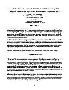
tispectral bands and generate another color enhanced image with high spatial resolution (Carper, 1990). The alignment of the images is the first step in this data transformation. Another example is combining optical and radar images. Radar images are not affected by clouds and weather conditions, and provide important complementary information about the region surveyed. For example, synthetic aperture radar (SAR) data from the Shuttle Imaging Radar-C (SIR-C) and Japanese Earth Resources Satellite-1 (JERS-I)data combined with TM optical sensor data have been used to map floodplain inundation and vegetation in the Manaus area of Brazil (Melack, 1994). SAR sensors are uniquely suited to measure floodplain inundation because they can detect flooding underneath vegetation, and they operate independently of cloud cover or solar illumination, while TM data provides additional information from the optical portion of the spectrum. The problem is that these sensors are on different platforms and in different orbits, each having different characteristics, viewing geometries, and data collection and * processing systems. This makes it necessary to register the images prior to their analysis. Analysis of changes in images taken at different times (temporal registration and change detection). In multitemporal image analysis, the objective is to detect changes which have occurred over a certain time period. A simple method to find changes in a pair of images is to overlay the images and detect the differences between them. Because these images are taken at different times and under different conditions, they have to be aligned prior to comparative processing. In computer vision, registration is necessary in extracting structure from motion, electronic image stabilization, and object recognition. Other problems such as finding cloud heights, satellite image composite generation, weather prediction, and wind direction measurements also involve the registration process. Two examples of image registration are shown in Figures 1 and 2. Figures l a and l b show balloon images from a Mojave Desert sequence taken with a CCD camera. They were part of a motion sequence with the camera attached to a floating balloon. Figure l c shows the mosaicking of Figures l a and l b after registering them. Figure 2 illustrates the multisensor registration of Landsat TM and SPOT images. As the SPOT images have higher spatial resolution than Landsat TM, the features appear at different scales and registration is necessary to integrate their information. Matching of the SPOT image after the transformation is shown in the Figure 2c. Photogrammetric Engineering & Remote Sensing, Vol. 62, No. 9, September 1996, pp. 1049-1056. 0099-1112/96/6209-1049$3.00/0
O 1996 American Society for Photogrammetry and Remote Sensing
(c) Figure 1.(a) and (b) are images from a Mojave Desert sequence; (c) is the mosaicking of (a) and (b). (Original images courtesy of JPL.)
In remote sensing applications, there is a critical need to develop automated image registration techniques which require minimum human interaction. Because the performance of a methodology is dependent on application specific requirements, sensor characteristics, and the nature and composition of the imaged area, it is unlikely that a single registration scheme will work satisfactorily for all different applications. Integration of multiple registration algorithms into a rule-based artificial intelligence system, which can analyze the image data and select an appropriate set of techniques for processing, appears to be a feasible alternative. Information such as the data type, features present in the imaged scene, registration accuracy, image variations, and noise characteristics could be provided by the user to assist in this process. The first step in the development of such an intelligent system would be a better understanding and characterization of the various different existing techniques. This is the main objective of this paper as we present a comparative study of recent image registration methods. In selecting the methods described here, the criteria used include potential for multisensor/temporal image registration and detailed experimental evaluation. Each methodology has been categorized with respect to the type of sensor data, modality (multi or single sensor), amount of test data used in the experiments, amount of overlap tolerated, as well as type of image feature, matching techniques, and type of transformations that have been used. In addition, some obsewations in relation to the merits and limitations of these methodologies are also presented. The organization of the paper is as follows. In the next
1050
section we provide the reader with an introduction to the image registration problem, describing the common tasks involved in the image registration process. Next, the description of selected algorithms for image registration proposed in the literature are presented, followed by a comparative study of these algorithms. Finally, we conclude with discussions.
The Image Registration Problem Image registration is the process of overlaying two or more images of the same scene. The one which is registered is called the reference image and the one which is to be matched to the reference image is called the sensed image. The general approach to image registration consists of the following four steps: Feature Identification. Identifies a set of relevant features in the two images, such as edges, intersections of lines, region contours, regions, etc. Feature Matching. Establishes correspondencebetween the features. That is, each feature in the sensed image must be matched to its corresponding feature in the reference image. Each feature is identified with a pixel location in the image, and these corresponding points are usually referred to as control points. Spatial Transformation. Determines the mapping functions that can match the rest of the points in the image using information about the control points obtained in the previous step. Interpolation. Resamples the sensed image using the above mapping functions to bring it into alignment with the reference image. In general, the registration methods are different from
September 1996 PE&RS
Figure 2. (a) and (b) are the Landsat and SPOT images, respectively, with scale difference; (c) shows the matching SPOT image after transformation. (Li et a/. (1995) O 1995 IEEE, original images courtesy of JPL.)
each other in the sense that they can combine different techniques for feature identification, feature matching, and mapping functions. The most difficult step in image registration is obtaining the correspondence between the two sets of features. This task is crucial to the accuracy of image registration, and much effort has been spent in the development of efficient feature matching techniques. Given the matches, the task of computing the mapping functions does not involve much difficulty. The interpolation process is quite standard and will not be discussed in this paper. Control Point Identification
Manual Registration The traditional manual approach uses human assistance to identifying the control points in the images. In this approach, the steps of feature identification and matching are done simultaneously. The images are displayed on the screen and the user chooses corresponding features in the images which clearly appear in both the images. Candidate features include lakes, rivers, coast-lines, roads, or other such scene-dominant man-made or natural structures. Each of these features will be assigned one or more point locations (e.g., the centroid of the areas, or line endings, etc.), and these points are referred to as control points. These control points are then used in the determination of the mapping function. In order to get precise registration, a large number of control points must be selected across the whole image. This is a very tedious and repetitive task. Furthermore, this approach requires someone
PE&RS
September 1996
who is knowledgeable in the application domain and is not feasible in cases where there is a large amount of data. Thus, there is a need for automated techniques that require little or no operator supervision. Based on the nature of features used, automated registration methods can be broadly grouped into area-based and feature-based techniques.
Area-Based Registration In the area-based methods, a small window of points in the reference image is statistically compared with windows of the same size in the sensed image. This process is illustrated in the Figure 3. Consider the sensed image S with M rows and N columns, and n windows W,, z = 1, .., n, with K rows and L columns extracted from the reference image R and centered at the point (a,,b,). Let S , denote the K by L subimage of S with its upper left corner coordinates (i,]], where S,(l,m)
=
S(i + 1,j + m),
(1)
forOIl