Augmented Reality
XenZu Technologies
[email protected]
Points of Interest
2
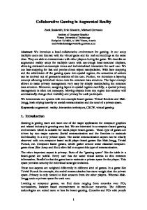
Application structure Tizen Native (C++)
Google maps server
User Interface
Google places server
network exchange
JS Bridge
Tizen Web
HTTP Service
Map view (html, css)
JSON service Location provider AR service
3
Map view logic (JavaScript)
Location provider • • • •
Get location with LOC_ACCURACY_ANY accuracy for the first time, and further refine with LOC_ACCURACY_FINEST Use cell-id, WI-FI and GPS system services Use a separate thread for updating location Try to Get Location at first, after Get Last Known Location and use timing Get Location if failed to get first time. Update location with schedule.
LocationCriteria opts; opts.SetAccuracy(LOC_ACCURACY_FINEST); Location loc = LocationProvider::GetLocation(opts); Location loc = LocationProvider::GetLastKnownLocation();
4
Interaction with Google Places server • • •
After acquiring location send HTTP request to Google server Set radius to search nearby places Use types to search places: restaurants, business, people, shops, movies, health, gas stations and other…
https://maps.googleapis.com/maps/api/place/nearbysearch/json?location=“”&radius=“”&types=“” request
Google Server response: list of POIs
parse response and save it to data model
JSON Parser
5
{
HTTP Service
single POI format
formatted_address, geometry : location : { lat, lng }, icon, id, name, rating, types : [ "restaurant", "food“ ] }
Map
Map view structure. Use Hybrid Application structure to implement maps FormMap.cpp
map.html
Web View
var mapProp = { center: myCenter, zoom: 13, scrollwheel: true, mapTypeId: google.maps.MapTypeId.ROADMAP };
m_WebView = static_cast (GetControl(IDC_WEB, true)); m_jsBridge = new JsBridge(m_WebView); m_WebView>AddJavaScriptBridge(*m_jsBridge); m_WebView->SetLoadingListener(this); m_WebView->LoadUrl( L"file://" + App::GetInstance()->GetAppDataPath() + L"map.html");
JsBridge.cpp - SetLocation() - SetRadius() - SetTypes()
map = new google.maps.Map( document.getElementById("map-canvas"), mapProp); var request = { location: myCenter, radius: radius, types: types }; infowindow = new google.maps.InfoWindow(); service = new google.maps.places.PlacesService(map); service.nearbySearch(request, callback);
7
Map view example Use search bar or menu to search places
Place info on map
8
Augmented Reality
Augmented Reality structure • FormAR.cpp Camera preview m_Camera = new Camera(); m_Camera->Construct(*this, CAMERA_PRIMARY); m_Camera->PowerOn(); … m_Overlay = GetOverlayRegionN( rect, OVERLAY_REGION_TYPE_PRIMARY_CAMERA); m_Overlay->GetBackgroundBufferInfo( bufferInfo);
•
class Point { … String m_Text; Bitmap *m_Icon; Coordinates Location; virtual void OnDraw() { CanvasTexture *pCanvasTexture = new (std::nothrow) CanvasTexture; pCanvasTexture->Construct( textureId, rect.width, rect.height ); Canvas *pCanvas = pCanvasTexture->GetCanvasN(); DrawIcon(m_Icon); DrawText(m_Text); pCanvas->Show();
m_Camera->StartPreview(&bufferInfo, true); } };
10
Use class Tizen::Media::Camera to display camera preview Use OpenGL library to display points over camera preview
Augmented Reality: Sensor Manager and Calibration • • •
Use Sensor Manager to get sensor data in real time: roll, pitch and azimuth; Calibrate all POIs with current TiltSensorData; Refresh UI after calibration.
m_SensorMgr.Construct(); m_SensorMgr.GetMinInterval(SENSOR_TYPE_TILT, interval); m_SensorMgr.AddSensorListener(*this, SENSOR_TYPE_TILT, interval, true); void FormAR::OnDataReceived(SensorType sensorType, SensorData& sensorData, result r) { TiltSensorData& data = static_cast(sensorData); // Set roll, pitch and azimuth for current location GoogleServices::GetInstance()->m_CenterSensorData = data; // Update canvas with new places coordinate UpdateVisiblePlaces(); }
11
Augmented Reality example •
• •
• • viewport width
12
During rotation of the device, form receives callback events from Sensor Manager; The application recalculates POIs coordinates; Check POIs for viewport width and height, translate POI coordinates to screen coordinates; Draw visible POIs; With the screen rotation we rotate viewport boundaries and refresh AR view with new visible POIs.
Summary • Hybrid application structure • This is prototype application • Open to use any places service Depending on the data received from server: • One step to road navigator application • One step to education application • One step to commerce application
13
Q&A
XenZu Technologies © 2014 www.xenzu.com
[email protected]