DESIGN AND IMPLEMENTATION OF MOBILE SPATIAL INFORMATION SYSTEM FOR PUBLIC HEALTH EMERGENCY Weixing Wang a, c, ∗ Jianhua Gonga, ∗ Weijun Yanga Dan Fengb Jinjin Zhanga Wuchun Caob a
The State Key Laboratory of Remote Sensing Sciences, Institute of Remote Sensing Applications, CAS, P.O. Box 9718,Beijing, China -
[email protected],
[email protected],
[email protected],
[email protected] b Institute of Microbiology and Epidemiology, Academy of Military Medical Sciences of PLA, Beijing, China
[email protected],
[email protected] c Graduate University of Chinese Academy of Sciences, Beijing, P.R. China -
[email protected] Commission VIII, WG VIII/2
KEY WORDS: Public Health Emergency, Mobile Geographic Information System, Personal Digital Assistant, Global Positioning System, Emergency Response Disposition, Mobile Collaboration
ABSTRACT: At present, as mobile devices like Personal Digital Assistant (PDA) or Handheld PC (HPC) are rapidly developed and the wireless Internet is increasingly used, interests in the mobile Geographic Information System (GIS) are gradually expanded. Nowadays, the outbreak of emergent public health events can be heard more often than before and make lots of people ill in a short time. How to deal with the events much more rapidly and efficiently are the main factors needed to be considered. With the development of mobile devices and wireless network, according to the characteristics of emergent public health event, the paper has designed and implemented a mobile spatial information system based on PDA for public health emergency. The platform integrates the technologies of GIS, Global Positioning System (GPS), Global System for Mobile Communication (GSM) and General Packer Radio Service (GPRS). A significant operation on the handling of emergency incidents is the danger identification and reasonable action taken in low response time. The system can instruct health care practitioners to make epidemiology investigation. At the same time, it can implement the functions such as data computation, statistic analysis, spatial analysis based on data collection. Thus, when public health emergencies break out, it can help to configure social resources more reasonably and support decision making much more scientifically.
are static, which means the process of date collection, management, analysis and result publication is based on fixed and cable connected network. It limits the flexibility of application in some extent. What’s more, the outbreak of emergent public health events, such as emerging infectious disease, serious alimentary toxicosis, occupational poisoning and so on, can be heard more often than before. How to relieve the harms to public health and life safety, the most effective and least consumed measure should be taken.
1. INTRODUCTION With the development of Geographic information systems (GIS), its applications expand to all kinds of domain, such as environment, architecture, public health, etc. Among which, GIS plays a more and more important role in the public health field. In order to properly plan, manage and monitor any public health program, it is vital that up-to-date, relevant information is available to decision-makers at all levels of the public health system. This must be done with best available data and taking into consideration disease transmission dynamics, demographics, availability of and accessibility to existing health and social services as well as other geographic and environmental features. GIS provide ideal platforms for the convergence of disease-specific information and their analyses in relation to population settlements, surrounding social and health services and the natural environment. They are highly suitable for analyzing epidemiological data, revealing trends and interrelationships that would be more difficult to discover in tabular format. Moreover, GIS allows policy makers to easily visualize problems in relation to existing health and social services and the natural environment and so more effectively target resources. However, at present, most of the applications ∗ ∗
At present, there has been an explosion of handheld digital devices in the past decade including digital media-players, digital cameras, GPS systems and networked communication devices and they have inevitably merged with the power of computers. These handheld computers are small, portable devices that can store and manage data as small as an address book to large databases of information that can be easily accessed and retrieved when needed. The combination of wireless and internet technologies allows more complex tasks including access to email and to special PDA-formatted Web channels, browsing Web sites and the ability to synchronize data between the PDA and a computer via the internet (Erdley, 2006; Fontanelo et al., 2003; Thompson, 2005). Significant advantages of the handheld computer include its small size, mobility, flexibility, and ease of use (Altmann and Brady, 2005;
[email protected]; phone 86-10-64849299; fax 86-10-64849299
[email protected]; phone 86-10-64849299; fax 86-10-64849299
445
The International Archives of the Photogrammetry, Remote Sensing and Spatial Information Sciences. Vol. XXXVII. Part B8. Beijing 2008
Operation Center. This will be achieved through the GSM network. Further more, through the GSM and GPRS network, other useful data, as well as voice messages, photos collected in the investigation places, can be transmitted. Therefore, mobile terminals can be collaborative with each other and Operations Center.
Koblentz, 2005; Tooey and Mayo, 2004). At the same time, industry is coming up with new, additional equipment embedded into PCMCIA cards: flash memory, Wireless Local Area Networks (WLAN), Global System for Mobile Communications/General Packet Radio Service (GSM/GPRS) modems and Global Positioning System receiver. Thus, interests in the mobile Spatial Information System are gradually expanded. There are a few research results related to applying mobile spatial information system to public health. Weigel and Cao (1999) and Derekenaris et al. (2001) combined GIS, GPS and optimization techniques to solve home delivery problems and ambulances routing problems, respectively. Derekenaris et al. (2001) developed a monitoring and control system applying GIS, GPS and GSM technologies for the effective management of ambulances. Dao, Rizos, and Wang (2002) and Baek, Seo, Lim, and Sicker (2005) provided some background to the technology underlying location-based services (LBS) using GIS, GPS and mobile communications, and some issues in developing and launching LBS. In this paper, a mobile spatial information system based on PDA for public health emergency is designed and implemented. The platform integrates the technologies of GIS, GPS, GSM and GPRS. It can instruct health care practitioners to make epidemiology investigation and the system implements the functions such as data computation, statistic analysis, spatial analysis based on data collection. Thus, when public health emergent events break out, it can help to configure social resources more reasonable, support decision making much more scientific, and take actions in time.
The equipments of system are personal computers and PDAs including the communication between PDA and GPS, the communication between PC via internet; bluetooth communication between PDA and handhold GPS, GPRS wireless communication between PC and PDA. Before starting for investigation field, collaborative server in the Operation Center is open, and so it is with the collaborative PC clients distributed in different working places by indoor workers so that collaborative work can be done in the collaborative virtual environment. When the communication is on between mobile clients (PDAs) and collaborative server, turn on the collaborative PC client agent to carry out the intercommunication with each collaborative PC clients.
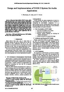
3. FUNCTIONAL ARCHITECTURE The details of the system architecture for mobile spatial information system for public health emergent events are realized using GIS, GPS and wireless communication technologies together with optimization techniques. Fig. 2 presents the functional architecture of the system. Main modules and functions of the system include: 1) Data collection module, including locale data collection, existed data collection and GPS information collection. Locale data cover the environment investigation data, the number of people who become ill, the symptom, blood pressure and so forth. Existed data comprise disease document, medical institution and medical services’ location and distribution, natural resources, social economy, etc. GPS information collection records the target’s precise location. Health care practitioners collect locale data and send them to the database in the Operation Center by GPRS. At the same time, they could download processed data to local PDA in order to meet the needs of the contents of data collection.
2. THE OVERALL INTEGRATED SYSTEM The system’s architecture is depicted in Fig 1. It is based on the integration of GIS, GPS, GPRS and GSM technologies.
Internet
Figure 1. System architecture
The GPS, GSM and GPRS technologies will be used to transmit the exact position of emergent public health event to Operations Center. Each health worker will be equipped with a GPS receiver to determine its exact position based on the signal transmitted by satellites. In addition, it will have a GSM modem in order to transmit its position to the base station in the
Figure 2. Functional architecture
446
The International Archives of the Photogrammetry, Remote Sensing and Spatial Information Sciences. Vol. XXXVII. Part B8. Beijing 2008
2)
3)
4)
5)
concept, which allows data to be sent and received without user interaction. (Prasad, 1999).
Data procession module includes database construction, consisting of attribute database and spatial database, and the connection between them. Medical animals’ distribution and their characteristics, natural resource, food security, social environment, medical resource, special investigation data and so on, constitute attribute data. When refers to spatial database, it consists of digital elevation model and remote sensing images, etc. As the processor capability of PDA is not so strong as table PC, the operation efficiency will be much lower when zooming in/out, panning, or querying among spatial data. So the data structure must be optimization organized. The paper designs and implements a data structure that can obtain high efficiency, which will be introduced in section 4. Geo-Information services module, includes geo-spatial positioning, spatial data displaying and analysis, query between attribute database and spatial database mutually, disease intelligent judgement, disposition release, etc. Geospatial positioning module calculates longitude and latitude coordinates of current object’s position, moving direction, and speed through the communication (NMEA 0183 V2.2 I/F) with GPS receiver. Then, the coordinate of positioning data should be transformed from WGS-84 to Gauss-80. What’s more, the map should be matched according to the object’s location. Spatial data displaying module emphasizes on displaying all kinds of standard formats of spatial data. Spatial data analysis module includes the functions of distance measurement, buffer analysis, path-found analysis, spatial data interpolation, spatial statistic analysis and classification. With the help of such functions, it’s especially useful for doctors, nurses, or other healthy workers to find the relationship between location, environment and diseases. What’s more, with the tools, it’s much easier to detect the disease cradle, and forecast the disease s’ development and evolution trends by means of epidemiology models, and then, it can help health care practitioners to take necessary actions in time to prevent and control emergent public health events. Query between attribute database and spatial database mutually module supplies tools to query objects’ attribute in spatial data interface or query objects’ spatial distribution and relationship with other objects through attribute interface. Disease intelligent judgement module is designed to judge what’s most probable disease should be according to the locale symptom or disease investigation data. Disposition release module shows the results of GIS analysis in the form of maps, tables, or other graphics and numbers. User interface design module includes how to treat with the commands and results feed back between users and PDA. It supplies interfaces between users and PDA. Users could input commands on maps displaying, information query and spatial analysis to system, and system replies in the form of graphics, images, text, tables, and so forth. Communications module. The communication between server and intelligent clients is through wireless network, such as GSM, GPRS, etc. GSM is the second generation system developed by European Telecommunications Standards Institute (ETSI). It offers data rates up to 14.4Kbps in circuit access mode and charging is carried out in relation to the connection time (Prasad, 1999). GPRS has been designed to solve GSM limitations, and offers a data packet switched access suitable for bursty transfers. Theoretically, data rates of up to 170Kbps can be reached, although a more realistic limit is 115Kbps. In addition, GPRS is the first system offering the “always on”
4. KEY TECHNOLOGIES 4.1 Study on Model for Mobile Collaboration Based on the system architecture and the actual results of field investigation, in order to meet the demands of both workers of outdoor field and their indoor cooperators to abstract the contents of their communications, we design a mutual model of mobile collaboration. In this model, the intercommunication can be carried out among field investigators and between workers of outdoor field and their indoor cooperators through wireless network, and at the same time, the indoor workers can communicate through Internet or Intranet. The sketch map of collaborative communication model between indoor and outdoor workers is shown in figure 3.
Fieldwork Worker
Server Client
Wireless network
Wireless network
Indoor Worker
Indoor Worker
Internet
Fieldwork Worker
Internet
Indoor Worker
Fieldwork Worker
Figure 3. The model framework of mobile collaboration 4.2 Interface between GPS and Windows CE The vast majority of PDAs utilize either the Palm operating system or Windows Pocket PC. The PDA mentioned in this paper utilizes Windows Pocket PC as its operating system, and the version is windows mobile 5.0. To get the precise location of emergent events is one of key points to take corresponding actions. Usually, GPS receivers are designed according to standard serial communication. However, Windows CE are not support asynchronous I/O operation, and there is no MSComm control as in table PC. To communication between GPS receiver and PDA by means of application program interface (API) is the best choice. What’s more, as the character set of API in Windows CE is in the form of UNICODE, the GPS receiver name that transmits to API function such as CreateFile should also use UNICODE. The device name turns up “XXXn:” in Windows CE, where n is an integer number range from 0 to 9, thus the name of serial communication device must be set as “COMn:” and the colon should not be omitted. 4.3 Maps Dynamic Load Based on Data Page Though the development of mobile devices is rapid, its process ability is limited when facing large amounts of GIS data. Usually, GIS data are stored in additional storage media, such as SD card, CF card, MMC card, etc. If PDA loads too much data to RAM once a time, it may be broken down and can’t be able to process other tasks any more. How to load the GIS data quickly when necessary is one of key problems should be
447
The International Archives of the Photogrammetry, Remote Sensing and Spatial Information Sciences. Vol. XXXVII. Part B8. Beijing 2008
solved. Accordingly, the dynamic load based on data page comes to be the best choice. The principle is described as follows, see Figure 4.
5. IMPLEMENTATION OF SYSTEM We implement the system for institute of microbiology and epidemiology, academy of military medical sciences of PLA. The adopted mobile terminal is Dopod 830 Pocket PC, with Windows Mobile 5.0 as its operating system. The GPS receiver adopted is AnyGPS-BT, with built-in antenna, 12 channels, and supporting for NMEA-0183 communication protocol. Also, some PDAs with built-in GPS are adopted, such as ASUS A632N, HP iPAQ series, etc. The system is used for biologic-terror defending rehearsing early this year in Fengtai district of Beijing held by the institute of microbiology and epidemiology, academy of military medical sciences of PLA. The health care practitioners’ response time is much shorter after biologic-terror occurs. With the help of the system, for one thing, they could deal with the emergent events skillfully during the process as they could search some related medical reference from PDA locally. For another, they could also keep contact with home base at realtime all the time by means of wireless communication, such as GSM, GPRS network, in the form of images, texts, voice, even video. Thus, it is much more effective in control of emergent events. Some specific functions run on the system are shown as follows:
Figure 4. Maps dynamic Load based on data page
Dynamic visualization describes the real-time loading of the data subset depending on the position of viewpoint. Because at a viewpoint, the part of data we can see which needs to be loaded is very limited. The total amount of data in memory should be limited. For example, the data in memory can be considered to be a rectangle block, when viewpoint moves to left, part of the data can be released and part of data must be loaded to memory, but there is always a rectangle block in memory. In this way, even global map data can be navigated on a common PDA. 4.4 Spatial Index Methods Index methods, such as R tree index, R+ tree index, grid index, and view frustum culling, can resolve the interactive visualization of GIS data in PDA. Grid index is relatively simple, but is widely used. It can satisfy the demand of application in common circumstance. The basic principle is to divide the whole area into cells equally or unequally and record the spatial objects in each cell. When spatial querying, the cell which contains the object is found out first, then the objects in the cell will be queried out quickly. Grid index is easy to implement. Its defect is that the size of cell has great influence on efficiency, which is difficult to confirm. R tree is a widely used spatial index with high efficiency. It adopts some virtual rectangle to comprise some objects in it. These rectangles are spatial index, comprising the pointers of spatial objects. The advantages of R tree are: 1) Organizing the index structure by data, so it is flexible and adjustable. 2) Before creating index, there is no need to know the range of spatial objects. After the index is created, when users increase or delete spatial objects, it can adjust the layers of tree. 3) It includes the characters of B tree, so it can be well melted with traditional relationship database, well supporting transaction, rollback and concurrency. R+ tree makes some improvement on R tree. The rectangles of brother nodes cannot be overlapped. This leads to better performance of spatial search. However, the efficiency to insert or delete a spatial object is lower.
Figure 5. Distance measure in spatial data displaying module.
According to the amount of tasks, grid index is adopted and implemented in the system. Figure 6. Attribute query interface.
448
The International Archives of the Photogrammetry, Remote Sensing and Spatial Information Sciences. Vol. XXXVII. Part B8. Beijing 2008
6. CONCLUSION In this paper, we have designed and implemented a mobile spatial information system based on PDA for public health emergency. It integrates GPS, wireless communication technique and network technique, including GPRS, GSM, etc. The system has been applied in biologic-terror defending rehearsing early this year in Fengtai district of Beijing held by the institute of microbiology and epidemiology, academy of military medical sciences of PLA. The expected results are obtained when dealing with emergent public health events. However there still exist some aspects need to be improved. 1) 2) Figure 7. Attribute query result.
3) 4)
The data collection module can only process images, texts at present. Medical models dealing with public health events are seldom. Most of the time, the decision disposition relies more on health care practitioners’ transcendental knowledge. The stability and the transmission speed of wireless communication also need improving. Technological development remains highly competitive and the current user interfaces for mobile devices have improved rapidly to fulfill the portable design brief, including the use of pen-based data input and small LCD displays. It appears the remaining interface restrictions need to be addressed to maximize the value of mobile devices for clinical practice.
With the development of mobile communication technologies, innovation in both PDAs’ software and hardware, the limitation of PDA’ processing ability and transmission speed of GSM, GPRS would take a breakthrough in the near future. Thus, videos could also be collected at locale in order to improve the data collection efficiency and the wireless network would be much more stable and reliable. Then, the mobile spatial information system applied in public health emergencies helps to configure social resources more reasonable, support decision making much more scientifically.
Figure 8. Disposition flows at locale.
REFERENCES Altmann, T.K., Brady, D., 2005. PDAs bring information competence to the point-of-care. International Journal of Nursing Education Scholarship 2 (1), Retrieved online June 6, 2006at:. (accessed 28 April. 2008) Baek, Jang Hyun, Seo, Jae Young, Lim, Seog Ku, & Sicker, D. C. (2005). An enhanced location-based location update scheme in mobile cellular networks. ETRI Journal, 27(4), 457-460.
Figure 9. Data collection interface.
Dao, D., Rizos, C., & Wang, J. (2002). Location-based services: technical and business issues. GPS Solutions, 6, 169-178. Derekenaris,G.,Garofalakis,J.,Makris,C.,Prenzas,J.,Sioutas,S.,& Tsakalidis,A.(2001).Integrating GIS, GPS and GSM technologies for the effective management of ambulances. Environment and Urban Systems, 25, 267-278. Erdley, W.S., 2006. Personal digital assistants, wireless computing, smart cards, and biometrics: a hardware update for clinical practice. JOGNN 35 (1), 157-163.
Figure 10. Healthy workers at locale equipped with the system.
449
The International Archives of the Photogrammetry, Remote Sensing and Spatial Information Sciences. Vol. XXXVII. Part B8. Beijing 2008
Fontanelo, P., Ackerman, M., Kim, G., Locatis, C., 2003. The PDA as a portal to knowledge sources in a wireless setting. Telemedicine Journal and E-Health 9 (2), 141-147.
vehicle-highway systems? Transportation Research C, 3, 193209.
Koblentz, E., 2005. The evolution of the PDA 1975-1995. Technology Rewind.Thompson, B., 2005. The transforming effect of handheld computers on nursing practice. Nursing Administration Quarterly 29 (4), 308-324.
ACKONWLEDGEMENTS This research is partially supported by the National High-tech R&D Program (863 Program) 2007AA12Z240, the National High-tech R&D Program (863 Program) 2006AA12Z109, and the Open Foundation of the State Key Laboratory of Remote Sensing Sciences (LRSS 0701). Thank VGE team of IRSA for program test of mobile collaboration, field survey and English paper writing. Thank research team of Professor Cao for field survey and lot of professional knowledge of public health.
Tooey, M.J., Mayo, A., 2004. Handheld technologies in a clinical setting: State of the technology and resources. Critical Care Nurse (Suppl.). Zito,R., D’este, G., & Taylor, M. (1995). Global positioning systems in the time domain: how useful a tool for intelligent
450