ASSESSMENT OF THE HAZARDS AND RISKS ASSOCIATED WITH THE SOUFRIERE HILLS VOLCANO, MONTSERRAT
Fourteenth Report of the Scientific Advisory Committee on Montserrat Volcanic Activity Based on a meeting held between 22 and 24 March 2010 at the Montserrat Volcano Observatory, Montserrat
Part I: Main Report
Issued on 14 April 2010
Summary (i) The last six months has seen some of the most energetic activity of the whole eruption. For four months between 4 October 2009 and 11 February 2010 about 70 million cubic metres of lava was extruded adding to the dome on the west, north and south sides and achieving its highest elevation yet at 1170 metres above sea level. Pyroclastic flows reached the sea at White River, Gingoes Ghaut (for the first time), Aymers Ghaut and along the northeast coast from Spanish Point to Trants. Also an explosion-derived pyroclastic flow reached a distance of 6 km down the Belham Valley on 8 January 2010, the longest yet, and less than one kilometre from Happy Hill in Zone B. The most spectacular event was the collapse of the dome to the north on 11 February 2010. Over a period of about 2 hours some 40-50 million cubic metres of dome and talus collapsed northwards. Fortunately, almost all of this mass travelled to the northeast where it buried the old Bramble airport and the buildings at Trants. Pyroclastic flow deposits extended the coast to the east by up to 650 metres. Violent blast-type flows destroyed many of the buildings of Harris. This event ended with a near-vertical explosion and the resultant ash cloud had a major economic impact on Guadeloupe. Since 11 February the volcano has been largely quiet. (ii) This activity follows the same pattern of that seen previously in 2008/2009: short duration (months) phases of lava extrusion at high rates, which is a departure from the longer episodes of activity seen in previous years. Evidence is accumulating as to what might have caused this change of regime but none is as yet compelling. The MVO’s deformation and the gas flux measurements suggest that the volcano is re-charging itself for another phase of lava extrusion (with possible explosions) and we think this is likely within the next year. (iii)The removal of the large mass of lava from the northern side of the dome on 11 February 2010 has reduced the risk around the Belham Valley considerably from the elevated levels of January-February, but significant hazards do remain on any restart of lava extrusion. We think the most likely type of restart (54% probability) will be extrusion of lava. This is most likely to occur within the collapse scar or explosion crater produced on 11 February, and lava dome growth from a vent here will give some protection, for a few months, from renewed flows into the Belham Valley. However, we must be very alert to the possible renewal of the type of activity that produced the blast-like flows that destroyed Harris, and the farreaching flows within the lower Belham Valley. (iv) We have applied our quantitative risk method using the Hazard Zones. Compared to September 2009, the general level of expected risk for the next twelve months has risen marginally. The calculated annual risk of death from the volcano to individuals who are full-time residents of Zone A is 1-in-6,640 (up from 1-in9,100 six months ago). For a full-time resident in Zone B the risk level is 1-in-610 (slightly up from 1-in-720 six months ago). Risk levels north of Nantes River remain extremely low (about 1-in-2 million).
ii
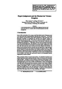
Fig.1 Hazard Zone boundaries of the Hazard Level System.
iii
Contents Introduction Recent Volcanic Activity Monitoring Results Probable Future Behaviour Assessment of Volcanic Hazards Assessment of Risks to People The Operation of MVO Future Science Meeting SAC Matters
1 1 2 3 4 4 7 8 9
Appendix 1: Appendix 2: Appendix 3: Appendix 4: Appendix 5: Appendix 6:
10 13 14 15 16 17
Constitution of the Scientific Advisory Committee Agenda of the March 2010 meeting List of meeting participants Preliminary Statement issued on 24 March 2010 Glossary of Terms Chief Medical Officer’s Risk Scale
iv
Introduction 1. The fourteenth meeting of the Scientific Advisory Committee (SAC) on Montserrat Volcanic Activity took place at the Montserrat Volcano Observatory (MVO) from 22 to 24 March 2010. This report is the main product of that meeting. The Committee was commissioned by the Foreign and Commonwealth Office and operates under the Code of Practice for Scientific Advisory Committees issued by the Office of Science and Technology. The Terms of Reference for the Committee are presented in Appendix 1, and the agenda of the meeting is given in Appendix 2. 2. Part I of the report of the meeting (this document) contains the main findings and Part II contains the technical aspects of the risk assessment. A Preliminary Statement from the full SAC meeting was issued on 24 March 2010 (Appendix 4). A radio phone-in with the public was held on the evening of 25 March with Kafu Cabey on ZJB. Appendix 5 provides a glossary of technical terms, and Appendix 6 gives a version of the Chief Medical Officer’s (CMO) scale of risk. 3. The fifth phase of dome growth, that had occurred since the previous meeting, gave us a huge amount to discuss, in particular the future strength and runout distance of pyroclastic flows to the north. The Director and staff at MVO provided us with excellent information, debate and support throughout. Recent Volcanic Activity 4. Four months of lava extrusion began in early October 2009, the fifth such phase of lava extrusion during the eruption. As in the activity of December 2008-January 2009 the dome grew mainly to the west, north and south in a relatively short period at a high rate. 5. Several exceptional events occurred during Phase 5. The lava dome grew to its highest elevation yet, at 1170 m above sea level. For the first time, on 4 November 2009, pyroclastic flows spilled over into Gingoes Ghaut on the southwest flank and flows down Aymers Ghaut reached the sea and travelled several hundred metres across it on 18 January 2010. A vulcanian explosion on 8 January 2010 was the largest by volume (about 6 million cubic metres) yet experienced, producing a flow that reached 6 km down the Belham Valley to within about 1 km of Happy Hill. On 11 February 2010 the largest dome collapse on the northern side of the volcano occurred. Although the ash from this event had little impact on Montserrat it had a major impact on Guadeloupe, where it disrupted air traffic for days and caused 25 million euros-worth of damage to crops. 6. In addition to the very large explosion on 8 January 2010, there were four other significant explosions in January and February; two on 10 January, 5 February and 8 February. At the end of the 11 February collapse event, explosions reamed out a new central crater in the top of the dome.
1
7. Although there were no large individual ash fall events on inhabited areas of Montserrat, the cumulative effect of such vigorous activity meant that fallen ash was a persistent annoyance for many weeks. 8. Very little material was dispersed to the east via the Tar River during this period and the northeastern lobe of the dome formed in early 2007 was barely affected by the new activity further west on the dome, though its eastern talus continued to be eroded, leaving steep cliffs of lava. In contrast, the upper parts of White River, Spring Ghaut and Tuitts Ghaut were largely buried by new deposits. However, the major change in topography occurred as a result of the dome collapse of 11 February 2010. Pyroclastic flows travelling northeast totally buried the old Bramble airport and Trants estate and entered the sea extending the coastline from Trant’s Bay to Spanish Point by up to 650 metres. 9. During the 11 February 2010 collapse, which lasted for nearly two hours, between 40 and 50 million cubic metres of dome and talus were removed. During the latter stages of this event, highly energetic pyroclastic flows and surges reached Harris village and destroyed many of the buildings there (see cover), including the school. The pressures developed in these flows were similar to those of the lateral blast that reached St Patricks village on Boxing Day 1997. Monitoring Results 10. MVO’s seismic network captured another remarkable feature of the Phase 5 activity; variable cycles of activity with periods between 4 and 14 hours. At the peak of the cycle there would typically be increased hybrid events, merging into tremor which often coincided with ash venting. Alternatively, the cycle would consist of variations in the number of rockfall and long period-rockfall events. There was a minor swarm of volcano-tectonic earthquakes from 4 to 6 October 2009 that marked the re-opening of the conduit through the dome. Variations in rockfall seismicity also showed evidence of three episodes of activity of about 40days duration that comprised this phase. 11. The GPS network measured a period of contraction or deflation across the island during lava extrusion. Like phase 4, the measured response to the beginning and end of extrusion was rapid and distinct: the slow inflation signal changed to one of rapid deflation at the start of the phase and reversed at the end. For the first time, it seems that the 40-day episodicity noted above is apparent in the GPS data. Deflation was greatest at the start to middle of the first two episodes and was reduced in the second half. 12. There were few measurements of sulphur dioxide flux due to instrument failure, but values in early October 2009 were in the range 200-600 tonnes per day. Satellite measurements of the eruption cloud of 11 February 2010 yielded an estimate of about 50,000 tonnes of sulphur dioxide, the third highest such measurement. As is usual during lava extrusion the measured ratio of hydrogen chloride to sulphur dioxide rose to values greater than 5 from levels below 1 during the preceding pause.
2
13. Although obscured by denser clouds the thermal camera at MVO was able to image the progress of some of the pyroclastic flows, particularly in the Belham Valley. Similarly, the climactic explosion of the 11 February 2010 event was partly imaged and appeared to have a northeasterly orientation. Probable Future Behaviour 14. As the dome stands there is still a large volume of recently emplaced mass high on the western side particularly over the Gages Valley and Chances Peak that might collapse suddenly. However, the 11 February collapse removed 40-50 million cubic metres from the northern flank and in doing so reduced the likelihood of new, imminent collapses to the northwest and into the Belham River Valley. There are several scenarios for the way in which the next major event or activity may start. The dome may remain stable for the next year or more, part of it might collapse suddenly following intrusion of new magma rising below or from intense rainfall, activity might resume with another explosion, or with the quiet extrusion of new lava. 15. Since 2008 the phases of extrusive activity have been shorter (months) and at higher average rates of flux than in the longer (years) preceding phases. Work on understanding how this can occur is ongoing, but three factors stand out. Firstly, the dome is large and high which means that the magma column has to have a high driving pressure to rise to the surface. Secondly, the volcano has emitted over one cubic kilometre of lava since 1995, and this may have gradually reduced the internal pressure of the magma reservoir at depth. Thirdly, there is some evidence that, since 2007, more of the basalt magma is being incorporated into the andesite magma before it rises to the surface. All three of these factors could tend to influence the magma to rise at a high rate but be unable to sustain that rate for very long, or as long as it used to. 16. The volcano is apparently entering a pause in lava extrusion after a four-month phase of remarkably vigorous activity, as we have seen. We think there is only a 9% probability that this pause will last a year or longer. We also consider that if activity does resume it is three times as likely to be of the high rate/short duration type that we have seen since 2008 rather than the longer duration episodes experienced before then. 17. We estimate that the probability that over the next year the first significant event will be the resumption of lava extrusion is 54%. Instead it may be a vertical explosion (13% probability) or harmless collapse of the dome to the south or east (10% probability). The other options are dome collapse events sending pyroclastic flows to the west (5.8%), northeast (4.4%) or northwest (2.6%) sufficiently large to reach the sea, or in the case of northwest as far as Happy Hill. Collapses involving lateral blasts are much less likely.
3
Assessment of Volcanic Hazards 18. As we emphasized in our last report, this volcano has shown again that, even after nearly fifteen years of activity it can send pyroclastic flows to new areas previously untouched. This includes locations within hazard zones B and F. This is partly a result of the high elevation of the dome and partly the high extrusion rates which can allow a large volume of hot, pressurized dome lava to accumulate. Both of these factors are likely to be in play during the next phase of activity. 19. The large explosion of 8 January 2010 sent the longest flow yet into the Belham Valley. Whilst we cannot rule out a similar event occurring as a prelude to the next restart, it seems less likely now that a wider and lower exit vent has been generated as a result of the 11 February event, and that there is less dome material available. 20. The collapse of 11 February 2010 removed much of the mass from the northern side of the dome. This material can now no longer take part in a similar collapse down the Belham Valley and thus has reduced the hazards relative to those of January and early February 2010. The threat has not been removed entirely, particularly from the mass further west over the Gages Valley. A large Gage’s Valley collapse that spilled out into the Belham Valey between St Georges Hill and Gages Mountain could be triggered by an intrusive restart as new magma tried to force its way upwards. However, given the depth of excavation into the dome by the collapse scar and the new explosion crater behind it, these are likely to provide easier passage of new magma. 21. If there were a relatively“quiet” restart of lava extrusion (as in October 2009) within the collapse scar or new crater, then there would be a period when that lava would be largely contained within the walls of the 11 February collapse. It would take about three months of the sort of extrusion rates we might expect to completely fill the scar left by the collapse. This would be a time of increasing hazard as pyroclastic flows that might spill over into the Belham Valley grew larger, though initially we would expect many of such flows to travel to the northeast, as they did in February. Eventually, we might expect conditions to be similar to those that existed in early February with highly pressurized lava susceptible to destabilisation with highly energetic flow behaviour. 22. The main hazards likely to be faced are: pyroclastic flows and surges from dome collapse, either initially by forcing from below or later by dome growth; vertical explosions creating large column collapse, highly mobile flows; lateral blasts after exposure of the hot core of the dome; tsunamis and mudflows. Assessment of Risks to People 23. We continue to use the fixed zone approach in which we take each hazardous process identified above, estimate the probability that they will occur and affect a given area of Montserrat and then calculate the risk to which a given number of people in that area will be exposed. The Zones defined by the Hazard Level 4
System (August 2008) are the ones used to define individual risk levels. We use the modified UK Chief Medical Officer’s (CMO*) scale (Appendix 6) to convey a qualitative description of the degree of the annualised individual risk based on the numerical estimates, but we also provide some alternative risk measures to add further perspective. Details of the probability and risk calculations are presented in Part II of this report. These risk estimates have large uncertainties and so the reader should not attribute detailed meaning to small numerical differences in quoted risk values. The descriptive CMO scale categories, as reported here, better capture these differences. We have also calculated the increased risk faced by individuals from the volcano by referencing it to the general “background” risk of accidental death thought to be typical for people living in Montserrat (a rate numerically equivalent to 28 per 100,000 people per year). 24. The general level of risk is assessed to be marginally higher than at the last assessment in September 2009 when, like now, there was a pause in dome growth. The factors influencing this are that there is still a large mass of dome at a high elevation, that we think the most likely next activity will involve renewed lava extrusion at a high rate, that we have seen an example of a pyroclastic flow capable of reaching Zone B in the Belham Valley and that there is now clear evidence that dome collapse to the north can generate destructive events comparable in damage potential to lateral blasts. The major factor tending to reduce the risk is that the 11 February 2010 event removed a large mass of potentially dangerous dome. 25. Risks to people living in Zones A and B On the basis of our quantitative risk modelling, the level of annualised risk of death (IRPA) due to volcanic hazards for an individual in each of the populated Zones (A and B) of Fig. 1 is: Zone A (full-time resident): 1-in-6640, C on the CMO* scale, 1.5x background risk level of accidental death Zone B (full-time resident): 1-in-610, B on the CMO* scale, 7x background risk level of accidental death. For Zone A the calculated individual risk exposure level has increased marginally when compared to that determined at the last, SAC13 assessment, from 1-in-9660; for Zone B the individual risk exposure level has also increased, from 1-in-750. The IRPA for the Woodlands area remains extremely low, about 1-in-2 million (for SAC13 the corresponding risk was 1-in-4 million). Zone C is unoccupied and we have not calculated a general risk level. 26. Risks to workers in Zone F (Corbett Spring-Locust Valley) This area is one designated for agricultural production with controlled access of limited daytime workers. However, its southern edge was overrun by surges from the 11 February 2010 event and all southern access is impossible. As a result we do not consider risks to workers this time.
5
27. Risks to workers in former Zone T (Trants) Given the devastation of the Trants area on 11 February 2010 and the thick pyroclastic deposits, which will remain very hot for months, there is little prospect of resuming sand and gravel extraction in the near future. Risks to workers there are therefore not considered here. 28. Risks to workers at Fox’s Bay and at Isles Bay The estimate of current risk exposure to workers at Fox’s Bay is increased somewhat. The workers’ IRPA now stands at about 1-in-850 per annum equivalent, or about 19x the corresponding UK occupational risk. In the accessible southern part of Isles Bay, behind Garibaldi Hill, the worker risk is estimated to be about 1-in-1300, which is about 12x the equivalent UK occupational risk. Thus, there is a modest margin of additional safety associated with the Isles Bay site relative to the Fox’s Bay option. For operational purposes, worker exposures for those involved in the transportation of aggregate to and from these sites would need to be considered also. 29. Risks to workers in Plymouth The MVO risk assessment for the salvage of barges beached at White River in October 2008 considered in detail the risk of operations at the Plymouth Jetty under conditions at the volcano at the time. To give a measure of context to that assessment, the annualised individual risk for a worker at the Plymouth Jetty, working normal hours for a whole year under those particular circumstances would have equated to an IRPA worse than 1-in-10, given the risk exposure at Plymouth Jetty estimated by MVO in October 2008. Over the last six months the situation at the volcano has become more threatening in this direction than in 2008, with recent pyroclastic flows (e.g. 8 January 2010) demonstrating the acute threat and extreme risk exposure at the jetty. Currently, therefore, an IRPA of 1in-10 cannot be considered other than realistic, a value greater than the exposure of a soldier in a major war. 30. Risks to workers involved in Geothermal Well Exploration An area in the centre of Zone C, between Garibaldi Hill and St George’s Hill, has been identified as a prospective area for geothermal well exploration. For that area, the following estimates of individual risk exposure for workers are put forward as indicative. For surface exploration activities taking place for a duration of, say, up to 6 months during the next year, working 12 hours per day, the corresponding IRPA is about 1-in-1200 per annum. For drilling activities involving 2 x 12 hour shifts, and a programme that may last up to, say, 9 months, the IRPA is about 1-in-800 per annum equivalent. A much more thorough risk assessment would be required prior to any drilling. 31. Risks in the Maritime Exclusion Zone The extension of the on-land measures applicable to Zones A, B and C to their offshore counterparts, argued by SAC in previous reports, was adopted by NDPRAC and those new limits are shown in Fig.1. The wording for access needs to be checked. The pyroclastic flows that swept out to sea for at least 1 – 1.5 km from the coast at Bramble airport/Trants on 11 February 2010 show the need for the MEZ. In this regard, the northernmost point of Zone E should probably be extended northwards by another 1 km to give an extra margin of safety against a 6
repeat of this type of event. The map should also label the vertices of the boundary polygons with their latitude and longitude values for ease of use by sailors. The Operation of MVO 32. The staff of MVO coped well with the demands of Phase 5, the first period of sustained activity for some of the staff and the first as Director for Dr Cole. The post of seismologist remains unfilled, but it is hoped to have someone in place by August 2010. Mr Simpson and Ms Badal had resigned and so the Software Engineer and Outreach Officer posts were again vacant. 33. Caribbean Helicopters had responded positively to an invitation to tender for another one year of helicopter provision with a minimum of 3 hours per week. They are able to provide a regular Wednesday service in the tourist low season but are less regular in high season. A DFID-funded MVO project to acquire a high resolution topographic survey of the volcano using airborne lidar is to go ahead in the next few months with the combined effort of Caribbean Helicopters and a survey company, Terrapoint. There was discussion of ways of improving the sampling of deposits. Helicopter landings in many places on the volcano had proved impossible because of the amount of ash thrown up. Dousing the site with water was suggested. 34. The seismic station at Harris had been destroyed on 11 February 2010. A new replacement Guralp instrument was available. There was a timing error with the instrument on Fergus Ridge, still to be resolved. The delayed installation of the WebObs system for intranet instrument interrogation should now go ahead in June. The various infrasound instruments should be better integrated with the seismic network. 35. The existing sulphur dioxide flux network has barely functioned over much the last 6 months due to heavy ashing and instrument malfunction, though the hydrogen chloride/sulphur dioxide ratio was measured occasionally. Also, the digitizer for the meteorology station at St Georges Hill was stolen and so wind measurements have to be obtained from Gerald’s; an unsatisfactory arrangement. The new spectrometers for measuring suphur dioxide are being tested and calibrated with the help of Dr. Vitchko Tsanev of Cambridge University. There will be three fixed instruments, two rovers and one spare. 36. Both the Harris and Hermitage GPS instruments were lost on 11 February. These are to be replaced and new instruments also installed at Fergus Ridge and perhaps Lee’s Yard or St Georges Hill. The re-establishment of campaign GPS measurements is planned, with an instrument rotated between sites by helicopter giving a set of measurements every 2-4 months. 3D motion vectors are now routinely produced by MVO using the GAMIT software. 37. New software for photogrammetry from any pair of photographs with common fields-of-view has been provided by Dr. Richard Herd of the University of East Anglia and is being tested. Similarly, new time-lapse camera systems have been trialled (at Fergus Ridge) and their images should now become part of the 7
operational system when telemetered. TerraSAR-X satellite images of valley morphology and field scale disks have been used to estimate deposit infill depths. 38. A new, two-year, contract for whole-rock geochemistry analysis of samples back to 2006 has been signed with Dr Jenni Barclay (University of East Anglia). Discussion on further provision for petrological analysis including microprobe analysis is underway. 39. Two very helpful recent visitors were Dr Mark Bernstein (State University of New York at Buffalo), who used his high-resolution thermal camera on the helicopter to image the temperature field of the dome, and Dr Maurizio Ripepe (University of Florence) who replaced his original infrasound network and installed a widerangled version of the thermal camera at MVO. At the end of April 2010 3D seismic data were due to be acquired offshore Montserrat by Dr Peter Talling as part of a study of the submarine deposits from the volcano. Dr Anne Le Friant continues her progress towards getting IODP to undertake deep drilling around the island in 2012/3. 40. The Hazard Level System was changed by NDPRAC from level 3 to 4 on 10 December 2009 when a pyroclastic flow reached the west end of Lees, beyond the pre-arranged distance of 3.5 km runout within the Belham Valley. This affected about 20-30 people still living in houses on the northern part of Zone B (no-one in Isles Bay Hill), who only had access to their homes during daylight hours. A decision on allowing daytime entry was made daily based on ambient activity and visibility considerations. The level was re-assigned as 3 on 23 February 2010. 41. There have been numerous outreach activities including Montserrat Earth Science week, an MVO open day, public lectures and teachers’ induction sessions. During the Phase 5 crisis there were daily interviews with the Director on ZJB. Dr Odbert engaged in a live link to a UK Science and Engineering Week event in Reading UK. Mr Jonathon Stone made a valuable contribution to outreach prior to his departure in mid-January 2010 and Mr Clevon Ash of SRC has helped out subsequently. Future Science Meeting 42. It is nearly five years since the successful “Ten Years On” science discussion meeting was held in Montserrat. It was felt that our understanding of the volcano had moved on since then and that now would be a good time to review that progress. Montserrat would be the obvious place to hold such a meeting, with MVO as host, perhaps in the Little Bay Cultural Centre over 2-3 days in about a year’s time. Other more focused meetings could follow on. Dr Cole offered to lay the groundwork for the meeting. This initiative could also catalyse the organisation of a new “memoir” of papers. Professor Wadge offered to carry this forward.
8
SAC Matters 43. A review of hazard and risk provision for the Caribbean Territories was undertaken by Mr Frank Savage of the FCO late in 2009. The recommendations of this with respect to the SAC are not yet known, but changes to the way the SAC operates may follow. Until this is known, and any changes are implemented, we will continue as before with a tentative date for the next meeting, SAC15, of 4-6 October 2010.
9
Appendix 1: Constitution of the Scientific Advisory Committee on Montserrat Volcanic Activity This document outlines the main responsibilities of the Scientific Advisory Committee (SAC) on the Soufriere Hills Volcano, Montserrat. The document includes the terms of reference for the SAC and a membership template. The SAC is to replace the Risk Assessment Panel and is commissioned by the Overseas Territories Department (OTD) of the Foreign and Commonwealth Office (FCO). The SAC will work according to the Office of Science and Technology (OST) Code of Practice for Scientific Advisory Committees. Terms of Reference The main responsibilities of the SAC are: 1. to carry out regular hazard and risk assessments of the volcano in co-operation with the Montserrat Volcano Observatory (MVO) and to report its findings to HMG and the Government of Montserrat; and 2. to provide scientific advice at a strategic level to HMG and the Government of Montserrat outside these regular assessments in co-operation with the MVO. NB: The “Government of Montserrat” will normally mean, in the first instance, the Governor as s/he has the constitutional responsibility for the safety of the Montserrat population. The Governor will be responsible for ensuring appropriate dissemination of SAC assessments or recommendations to the Government and people of Montserrat. The SAC is also required to perform these additional functions: 3. to provide independent advice on the scientific and technical operations of the MVO to ensure that the work matches the level of risk; 4. to provide scientific advice and assistance to the MVO as required by the MVO Director; and 5. to offer advice on new developments that were not foreseen when the TORs were set up, and if appropriate make recommendations for changes to the TORs. The SAC will carry out its activities within the OST Code of Practice for Scientific Advisory Committees. The SAC will be responsible to the UK Government through the FCO (OTD). The SAC will not incur expenditure without prior FCO (OTD) authority. These general terms of reference are supplemented with the following specific points: (a) The work of the SAC concerns scientific assessment of the volcanic activity and related hazards and risks. This scientific work is an input to decisions made by the HMG and the Government of Montserrat related to the safety of the people of Montserrat (such as evacuation and extent of Exclusion Zones), to issues of planning and sustainable development of Montserrat and to the mitigation of external hazards (e.g. to civil aviation). (b) The provision of scientific advice to the Governor and Government of Montserrat is the responsibility of the MVO and its Director. The SAC has the 10
function of assisting the MVO in its major missions in all respects of its activities and to assist in matters relating to the provision of long-term and strategic matters. (c) The MVO Director (or scientific staff designated by the Director) participate in all SAC activities except for ToRs 3 and 4. (d) The SAC has the function of giving advice and assistance to MVO and the management contractor relating to scientific matters as required by the MVO Director. Such independent advice to the MVO may include appraisal of the technical expertise of staff, evaluation of the monitoring systems, assessment of proposed research projects by external groups, and advice on technical matters. (e) With respect to ToR 3 the Chair of the SAC will be a member of the MVO Board of Directors and can provide independent advice to the Board as required. The Chair will be expected to attend MVO Board meetings (currently twice a year). (f) Given the special circumstances of Montserrat as a United Kingdom Overseas Territory, reports of the SAC would be provided for both Governments. Reports would also be given to the MVO Management Board. (g) The SAC will be required to present its findings in a manner suitable for release to the public. It will also be required to assist the Governments and the MVO in explaining the activity of the volcano and the scientific information pertinent to decision-making by the authorities. (h) The SAC will liaise with other relevant scientific organisations or committees as required, which might for example include regional scientific institutions and the Department of Health Committee on health hazards from volcanic ash. (g) The Chair of the SAC will make an annual report to the MVO Board of Directors. MEMBERSHIP Membership of the SAC will be at the invitation of the FCO (OTD) and will cover the key areas of expertise required to assess the hazards and risks of erupting volcanoes. Expertise will include such areas as volcanology, volcano geophysics, and hazard analysis. The SAC will continue the approach of the former Risk Assessment Panel that was endorsed by the UK Chief Government Scientist in December 1997. Thus the Committee requires a facilitator as a member for applying expert elicitation methods to estimate volcanic risk. These considerations imply a minimum of four members, excluding the Director of the MVO. Additional experts can be invited to participate as required by the Chair, with prior agreement from the FCO (OTD), if a lack of expertise becomes apparent on a particular issue. As required by the Code the SAC is expected to consider external opinion. The membership will be considered on an annual basis with a view to regular changes and refreshment of membership. MEMBERSHIP TEMPLATE Members invited to serve on the SAC for the Montserrat Volcano are expected to attend all hazards and risk assessment meetings and to participate in the formalised elicitation procedure. Members have the responsibility to use their scientific judgement and expertise to meet the Terms of Reference. Opinions of the Members on scientific matters should be expressed through participation in the work of the SAC. Divergences of scientific opinion will normally be reported in terms of scientific uncertainty through the formal expert elicitation procedure. Differences that cannot be incorporated through the elicitation methodology 11
should be included in the reports of the SAC as required by the OST Code. The Chair of the SAC, or his or her delegate from the Committee, will be responsible for presenting the findings of the SAC’s work to the Governments of Montserrat and the United Kingdom and to the public in co-operation with the Director of the MVO. Any disagreement or divergence of opinion with the Director of the MVO that cannot be reconciled or incorporated through the elicitation method should be reported through the MVO Board of Directors. SECRETARIAT The FCO (OTD) will provide a Secretariat for the SAC, as set out in the Code of Practice. FCO (OTD) will reimburse premium economy travel costs, reasonable hotel accommodation, meals and professional fees (once agreed) in full. The SAC will not incur additional expenditure without prior FCO (OTD) authority. The Secretariat’s main point of contact is Alison Marshall, Desk Officer for Montserrat in OTD. His contact details are as follows: Email: Alison
[email protected] Tel: +44 20 7008 3123 Fax: +44 20 7008 2879
12
Appendix 2: Agenda SAC14
22-24 March 2010
1. This meeting, public meeting 2. MVO Activity Report 3. 11 February event 4. State of the dome 5. Pyroclastic flows in the Belham valley 6. Short and sharp extrusive regime? 7. Long-term prognosis 8. One-year hazard scenarios elicitation 9. Risks in the Hazard Zones C: St Georges–Richmond Hill A: Olveston-Salem B: Old Towne-Belham F: Corbett Spring-Locust Valley T: Trants 10. Work/Visit Geothermal Project Foxes Bay/Isles Bay Plymouth 11. Maritime exclusion zone 12. MVO Matters Helicopter Monitoring Collaboration Hazard Level System Outreach 2011 Conference 13. SAC Matters Membership/Future Next meeting
13
Appendix 3: List of Participants
Chairman Prof. G. Wadge
ESSC, University of Reading, UK
Committee members Dr. W.P. Aspinall Aspinall & Associates & Bristol University, UK Prof. J. Neuberg
Leeds University, UK
Prof. B. Voight
Penn. State University, USA
Prof. K.V. Cashman University of Oregon, USA (tele-presence only) People present in an advisory or observer capacity Dr. P. Cole (Director, MVO) Dr. R. Robertson (MVO, Director SRC) Mr. R. Stewart (MVO, SRC) Dr. J-C. Komorowski (MVO, IPGP) Dr. T. Christopher (MVO) Dr. H. Odbert (MVO) Dr. A. Stinton (MVO) Ms V. Bass (MVO) Mr R. Syers (MVO) Mr P.Williams (MVO) Mr M. Fergus (MVO) Dr. E. Joseph (SRC) Mr C. Eligon (SRC) Prof. S. Tait (IPGP) Dr. J.-B. Chevalier (IPGP) Dr B. Taisne (IPGP) Ms M. Plail (University of East Anglia)
14
Appendix 4: SAC14 Preliminary Statement, 24 March 2010 The past six months have seen some of the most vigorous activity of the whole eruption. From 4 October 2009 to 11 February 2010, the fifth episode of extrusive activity increased the volume and height of the dome to the largest yet seen. The dome grew to the south, west and north at different times and produced many pyroclastic flows in these directions, including the first flows to enter Gingoes and Aymers Ghaut and reach the sea. Significant explosions occurred on five occasions in January and February 2010, the one on 8 January was the largest by volume of the eruption and sent a pyroclastic flow 6 km down the Belham Valley, the furthest yet. Ash often fell on inhabited areas throughout the episode. On 11 February 2010, a day after a change in dome growth direction, the northern part of the dome with a volume of 40-50 million cubic metres collapsed over a twohour period, producing large pyroclastic flows and surges mainly to the north and northeast. These extended the coastline between Trants and Spanish Point, adding about one square kilometre of new land. Two smaller flows also entered the Belham Valley. Towards the end of the collapse there was an energetic pyroclastic flow directed northwards over Streatham and Harris. This sent flows over the Harris Ridge into Bugby Hole and down the Farm River for the first time. The event ended with vertically-directed explosions that reamed out a new crater immediately behind the collapsed part of the dome. The event generated a large ash column with extensive ash fall on Guadeloupe and other parts of the eastern Caribbean. Since 11 February, surface activity has been very quiet, and likewise seismicity has been very low. The GPS deformation measurements since then have indicated that deep deformation has resumed. This, coupled with gas measurements, indicates that the volcanic system remains active. Despite the removal of a significant portion of dome from the northern slopes, a large mass of dome remains at a high level that could still collapse to the north. We think the most likely next new activity is a renewal of lava extrusion. The pattern of shorter extrusive phases noted at SAC13 continues. Preliminary estimates based on current conditions indicate that the risks faced by people in Zones A and B are slightly higher than six months ago. As we saw on 11 February, extremely dangerous events, impacting hazard zones A and B without warning, remain a very real possibility.
15
Appendix 5: Glossary of Terms Andesite: The name given to the type of magma erupted in Montserrat. Basalt: The type of magma entering the magma reservoir below Montserrat. cGPS: Continuously-measured Global Positioning System for repeated measurement of ground deformation. Conduit: In a volcano magma flows to the earth’s surface along a pathway known as a conduit. The conduit is usually thought to be a cylindrical tube or a long fracture. Dyke: Vertical, tabular body of magma within a fracture below the volcano that can act as the conduit for flow to the surface. EDM: Electronic Distance Measurements made by laser ranging to reflectors gives length changes of a few millimetres accuracy over several kilometres. Hybrid/LP Seismicity: Varieties of earthquake signal often indicative of magma motion in the upper part of the conduit. Lava: Once magma gets to earth’s surface and extrudes it can be called lava. Below ground it is always called magma. Lateral Blast: An energetic sideways-directed explosion from a lava dome that can generate highly fluid pyroclastic flows. Magma: The material that erupts in a volcano is known as magma. It is not simply a liquid, but a mixture of liquid, crystals and volcanic gases. Magma must contain enough liquid to be able to flow. Magnitude: The magnitude of an explosive eruption is the total mass of material erupted. Mudflow: A flow of rock debris, ash and mud that occurs on many volcanoes particularly during eruptions and after very heavy rain Pyroclastic flow: These are flows of volcanic fragments similar to avalanches of rock in landslides and snow avalanches. They can be formed both by explosions and by parts of an unstable lava dome avalanching. Pyroclastic surge: These are also flows, but they are dilute clouds rather than dense avalanches. A surge is a rapidly moving mixture of hot particles and hot gas and their behaviour can be compared to a very severe hurricane. Surges can be formed above pyroclastic flows or directly by very violent explosions. Swarm: A large number of, in this case, earthquakes occurring in rapid succession with characteristics indicating they are generated from a similar region in the earth. Can merge into tremor. Talus: A pile of cool lava blocks and ash that accumulate by rockfall around the core of the hot lava dome. Volcanic ash: Ash particles are defined as less than 4 millimetres in diameter. Respirable ash consists of particles less than 10 microns (a micron is one thousandth of a millimetre) in diameter.
16
Appendix 6: Modified Chief Medical Officer’s Risk Scale (CMO*) Negligible (F): an adverse event occurring at a frequency below one per million. This would be of little concern for ordinary living if the issue was an environmental one, or the consequence of a health care intervention. It should be noted, however, that this does not mean that the event is not important – it almost certainly will be to the individual – nor that it is not possible to reduce the risk even further. Other words which can be used in this context are ‘remote’ or ‘insignificant’. If the word ‘safe’ is to be used it must be seen to mean negligible, but should not import no, or zero, risk. Minimal (E): a risk of an adverse event occurring in the range of between one in a million and one in 100,000, and that the conduct of normal life is not generally affected as long as reasonable precautions are taken. The possibility of a risk is thus clearly noted and could be described as ‘acceptable’ or ‘very small’. But what is acceptable to one individual may not be to another. Very low (D): a risk of between one in 100,000 and one in 10,000, and thus begins to describe an event, or a consequence of a health care procedure, occurring more frequently. Low (C): a risk of between one in 10,000 and one in 1,000. Once again this would fit into many clinical procedures and environmental hazards. Other words which might be used include ‘reasonable’, ‘tolerable’ and ‘small’. Many risks fall into this very broad category. Moderate (B): a risk of between one in 1,000 and one in 100. It would cover a wide range of procedures, treatment and environmental events. High (A): fairly regular events that would occur at a rate greater than one in 100. They may also be described as ‘frequent’, ‘significant’ or ‘serious’. It may be appropriate further to subdivide this category. Unknown: when the level of risk is unknown or unquantifiable. This is not uncommon in the early stages of an environmental concern or the beginning of a newly recognised disease process (such as the beginning of the HIV epidemic). Reference: On the State of Public Health: the Annual Report of the Chief Medical Officer of the Department of Health for the Year 1995. London: HMSO, 1996.
17