The Doan Brook Handbook
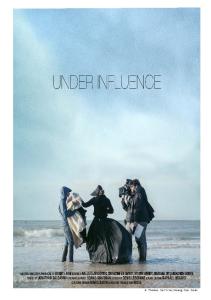
The Lower Shaker Lake dam overflows into North Park Boulevard. August 31, 2001. Photograph by L.C. Gooch.
For it was rather exciting. The little dry ditches in which Piglet had nosed about so often had become streams, the little streams across which he had splashed were rivers, and the river, between whose steep banks they had played so happily, had sprawled out of its own bed and was taking up so much room everywhere, that Piglet was beginning to wonder whether it would be coming into his bed soon. — A.A. Milne Winnie-The-Pooh
58
The Doan Brook Handbook
7
The Brook in the Rain: The Hydrology of the Doan
Most of the time, Doan Brook seems a peaceful, harmless trickle. We cross it without a thought. Most of us don’t even really know that it is there. Sometimes when it rains, though, Doan Brook wakes up and gives us a shake to remind us of the power that it has to shape the land. Then, briefly, the brook mocks our efforts to control it. It turns roadways into whitewater rapids; it forces its way into buildings and destroys their contents; it erodes its banks, threatening the streets that run along them; it eats at the dams that we have thrown across its path. Concern about flooding along Doan Brook rises and falls with the flood waters. Each large flood generates a wave of interest and a call for action. By the time a study is made and a solution proposed, the sense of urgency created by the flood has receded. Funding is hard to come by, and work is postponed. In effect, the community’s decision over the years has been that we can live with an occasional flood along Doan Brook. This chapter explores the nature, origins, and impacts of Doan Brook’s floods.
7.1
A History of Doan Brook Floods The earliest reported flood on Doan Brook occurred in 1901, when a flash flood roared down Cedar Hill from the Heights. Entire neighborhoods were inundated. Flooding was relatively rare in 1901, but high water has been a regular occurrence since the 1920s, when true urbanization of the upper watershed began. Readily available flood records are incomplete, but it seems that at least once each decade the brook erupts above ground in University Circle, reminding us that it once flowed there. Significant floods left 10 to 11 feet of water in the Circle in 1959 and 1975. Lesser floods in 1962, 1976, during the 1980s, and in 1994 also inundated the area. General flooding in the lower watershed was reported in 1929, during the 1940s, and in 1956. Table 7-1 summarizes records of the more damaging floods. The worst Doan Brook flood occurred in August 1975, when a man was swept to his death in a culvert near the intersection of East 105th Street and East Boulevard.With University Circle under eleven feet of water, the Sears Library and
other buildings at Case Western Reserve University (CWRU) were flooded, causing the destruction of 11,850 books and damage to almost 100,000 other books and maps. Other University Circle buildings were also flooded, and there was extensive destruction in the parks both upstream and downstream from University Circle. Both of the Shaker Lake dams were damaged, with severe damage at Horseshoe Lake. In addition, erosion of the stream bank in the Doan Brook gorge threatened Fairhill Road near its intersection with Kemper Road. Total monetary losses from this flood were estimated at over $10,000,000. Although other floods have not been as serious as the one in August 1975, news of flooding along the brook has been a recurring refrain. Water has flowed over Horseshoe Lake dam at least four times, resulting in serious damage and subsequent repairs to the dam. Repairs made in 1997 were intended to make the dam safer during future overtopping. The brook banks near Fairhill and Kemper were damaged repeatedly by flood erosion between 1959 and 1976, when a definitive slope repair was
59
The Doan Brook Handbook
Table 7-1
An Incomplete History of Doan Brook Flooding
Date
Description
1901
A flood roars down Cedar Hill and inundates entire neighborhoods.
June 1929
A flood washes out some sections of the retaining walls along Doan Brook.
1940s
Horseshoe Lake dam overtops and the south end of the embankment washes out.
1956
Eleven floods between May and August seriously damage the stream banks, retaining walls, and adjacent developments within the City of Cleveland.
For a Single Storm (date unknown): Rainfall: 3" Peak flow = 2,500 cfs
June 1, 1959
A major flood leaves water 10 feet deep in University Circle. Horseshoe Lake dam partially fails. The bank of the brook along Fairhill just downstream from Kemper erodes so that the north curbing of Fairhill is exposed.
Rainfall: 3" in < 1 hr. Peak flow = 18,000 cfs Return Period = 50 yr.
June 4, 1962
Flooding leaves 3 to 4 feet of water in University Circle.
Rainfall: 1.5" in < 1/2 hr. Return Period = 10 yr.
July 28, 1964
A more minor flood occurs, bringing the Lower Shaker Lake dam close to overtopping.
July 17, 1968
A relatively minor flood washes away the banks along Fairhill Road to within 6 feet of the pavement at one point. There is also damage at Fairhill and East Blvd.
August 24, 1975
A rainfall of 6 inches falls on the Doan Brook watershed and results in a flood depth of 11 feet in low areas of University Circle. The storm causes severe flood damage and is followed by a second storm and flood of nearly equal magnitude 4 days later. A man swept into a culvert near East 105th Street and East Boulevard is killed during the first storm. The stream bank near the intersection of Fairhill and Kemper Roads fails due to erosion. Horseshoe Lake dam is severely damaged by overtopping.
First Storm: Rainfall: 3.25" in < 1 day at the Lower Lake; over 6" in some areas. Return Period = 50 yr. Second Storm: Rainfall: 3.5" in 3 days at Lower Lake.
July 14, 1976
The University Circle area floods with several feet of water. Horseshoe Lake dam overtops and is severely eroded, leaving the downstream side of the stonework exposed.
Rainfall: 3.5" to 4.5"; time unknown, but < 1 day.
July 1990
Flooding along the lower brook, including a drowning.
August 13, 1994
A storm causes traffic disruption and property damage in University Circle and damage to Horseshoe Lake dam.
August 29-31, 1975
performed. Minor damage to bridges and retaining walls and disruption of traffic along Martin Luther King, Jr., Boulevard is a regular occurrence in the lower watershed. After the 1975 flood, CWRU decided that it was best to
Technical Data
simply get out of the brook’s way and moved facilities that could be damaged out of the reach of the flood waters. They also installed water-tight “submarine” doors to keep the brook out of some buildings. Partly as a result
60
of this action by CWRU and partly because subsequent floods have been less severe, no major damage has been caused by more recent floods.
The Doan Brook Handbook
7 The Brook in the Rain: The Hydrology of the Doan
7.2
Where Does the Water Come From? Watershed Runoff Patterns The history of Doan Brook flooding makes it clear that the most damaging floods along the brook occur at University Circle. Flooding there results from a combination of the hydrology of the watershed and the design of the University Circle culvert, which periodically interact to dump an overwhelming quantity of water into University Circle. The Circle lies at the base of the Escarpment and near the middle of the Doan Brook watershed.1 Water in the brook (as it passes through the University Circle culvert) originates in five distinct areas: • The Plateau upstream from the Lower Shaker Lake (57% of the University Circle watershed); • The Plateau that drains to the brook between the Lower Shaker Lake and the Martin Luther King, Jr., Boulevard (MLK) detention basin (9% of the University Circle watershed); • The Plateau and Escarpment that were part of the former Giddings Brook drainage area (18% of the University Circle watershed); • The Plateau and Escarpment that drain to the Cedar Glen storm sewer (12% of the University Circle watershed); • The Lake Plain and Escarpment that drain to the Euclid Avenue storm sewer (4% of the University Circle watershed). When the brook enters the University Circle culvert, it carries runoff from the Plateau that originates both upstream and downstream from the Lower Shaker Lake. Just downstream from the main culvert inlet, two large storm
sewers — the Giddings Brook culvert2 and the Cedar Glen sewer — connect with the main University Circle culvert. These two storm sewers carry the runoff from the former Giddings Brook watershed and the Euclid Heights area, respectively. A third storm sewer intersects the main culvert at Euclid Avenue. The total drainage area that contributes flow to University Circle is approximately 5,560 acres, or 74 percent of the Doan Brook watershed. (See Figure 5-4 and Table 5-1 for a summary of drainage areas at critical points in the watershed.)
(which together make up about 39 percent of the watershed at University Circle and 28 percent of the brook’s total drainage area) reach the stream much sooner than the flow making its way through the Shaker Lakes. Figure 7-1 is a schematic representation of the timing and magnitude of flows from upstream and downstream from the Lower Shaker Lake as they reach University Circle. It clearly shows the relative contributions of runoff that originates upstream and downstream from the lakes.
Because of the Shaker Lakes, flow from the Plateau upstream from the Lower Shaker Lake reaches University Circle much later than flow from areas downstream from the lake. In fact, runoff from the area upstream from the lakes plays a minor role in University Circle flooding. The slope of the land and the density of the urban area are moderate upstream from the lakes, so water collects relatively slowly. More important, runoff must pass through the lakes before it reaches University Circle. The lakes play a critical role by storing and slowly releasing water that flows through them (see What Do the Lakes Do?).As a result, downstream floods are much smaller than they would otherwise be.3
7.3
Unlike water that flows through the lakes, water that originates downstream from the Lower Shaker Lake finds few barriers in its path as it flows toward University Circle. The areas that drain into the downstream brook channel and into the Cedar Glen sewer and the Giddings Brook culvert are the denser urban neighborhoods that lie on the western edge of the Plateau and on the Escarpment. Water from these areas collects quickly and takes an unobstructed path through the storm sewer network to the brook at University Circle.4 As a result, the sharp, high flood peaks from these areas
Why Is There a Flood? The Brook Under Duress The reasons that the fast-flowing runoff from the uncontrolled areas of the Plateau and Escarpment so often overwhelms the brook at University Circle can be summarized in two phrases: Giddings Brook and the impact of urbanization. As Chapter 5 discusses in detail, the urban watershed, with its abundant buildings, pavement, and storm sewers, sends far more water into Doan Brook than flowed into the brook under pre-development conditions. The average annual runoff to the stream from a given area may be three times as great as it was in Nathaniel Doan’s time, and a five-year flood5 may be four times as large. The extra watershed area added by the diversion of Giddings Brook into Doan Brook further increases floods, so that the annual runoff is as much as four times greater and the five-year flood may be increased by a factor of five. The culverts and channels that were built in the lower Doan Brook watershed beginning in the late 19th century might have been adequate to carry the brook before urbanization and before the Giddings Brook diversion, but
1 See Chapter 3 for a discussion of watershed topography and the definition of the Escarpment and other topographic regions. 2 This culvert runs down Baldwin Road and is sometimes called the Baldwin Road culvert or sewer. 3 For example, during a moderate flood that might occur once in five years, the Shaker Lakes are estimated to reduce the peak flow from the upstream watershed by about one-half and to delay the peak flow downstream from the Lower Shaker Lake for over two hours. 4 Runoff that does not pass through a lake or other structure that would slow and reduce the peak flow is referred to as uncontrolled runoff. Areas that are not upstream from a control structure such as a dam or detention basin are called uncontrolled drainage areas. 5 See Appendix H for a definition of the 5-year flood.
61
The Doan Brook Handbook
Flow
Inflow to University Circle from Area Below Lower Shaker Lake
Inflow to University Circle from Area Above Lower Shaker Lake
Not To Scale
Time Figure 7-1 Typical Flows at University Circle
they cannot carry the modern runoff.6 We have built around and on top of the brook, so that any adjustments the stream tries to makes to accommodate larger flows are destructive — they erode banks, threaten roadways, and overtop the Shaker Lake dams. In short, there are frequent floods along Doan Brook because we have caused more water to flow to the brook and we have given the stream less room to carry the flow.
7.4
How Strong Are the Dams? The Safety of the Shaker Lake Dams In the late 1970s, the Ohio Department of Natural Resources (ODNR) and the U.S. Army Corps of Engineers evaluated the Horseshoe Lake and Lower Shaker Lake dams to see whether or not they were in danger of failing and to assess the danger that a dam failure
would create. They concluded that the failure of either of the dams could cause serious property damage and some risk to human life. This risk would stem from the inundation of roads and bridges and from high water in the University Circle area as the flood wave from the dam failure moved downstream. The agencies determined that both dams were subject to failure by overtopping7 during the Design Flood — a flood one-half the size of the Probable Maximum Flood.8 Because of the risk created by failure of either dam, they were given “high” hazard rankings by the Corps of Engineers. Because both dams were considered to have a reasonable possibility of failure, the agencies indicated that action was needed to protect them. Several measures have been taken since the initial evaluation of the dams to increase their safety. The Horseshoe Lake dam was repaired in 1995 by filling a low spot on its crest, paving the pathway across the crest, and placing large
rock riprap9 on the dam’s downstream face. This was intended to protect the dam by eliminating a low spot that would overtop before the rest of the dam, by reinforcing the crest against erosion, and by making the downstream face more erosion resistant. The Lower Shaker Lake dam has also been repaired. Fill was placed on the downstream face of the dam north of the outlet channel, and some additional work was done to reinforce the downstream slope near the ruin of the Shaker sawmill. In 1999, the stonework in the dam’s spillway was repaired, and an outlet was installed in the lake so that the water level could be lowered to allow future dam inspections. ODNR has continued to express concern about the condition of both of the Shaker dams and the possibility that either dam could be seriously damaged or fail as a result of overtopping. After their most recent formal inspection in May 1996, ODNR required minor, routine repairs to both dams. These minor repairs appear to have been completed since. More significantly, ODNR required that studies be performed to evaluate the size and design of emergency spillways that would prevent overtopping during the Design Flood. Action on this last requirement has been slow.
7.5
How Big Is the Pipe? The University Circle Culvert and the Downstream Channels When Doan Brook floods, the University Circle culvert overflows. The 5,160-foot-long culvert that carries the brook from the intersection of Martin Luther King, Jr., Boulevard (MLK) and Ambleside Drive past the Cleveland Museum of Art is actually a series
6 In fact, the first sign that urbanization was overwhelming the rigid channels in the lower watershed came as early as 1929, when a flood washed out part of the channel. The first enlargements to the channel in Rockefeller Park were made in 1932 and 1940. 7 A dam is “overtopped” when water flows over the dam at a point where it is not designed for overflow. Overtopping is dangerous to an earth dam because it causes erosion and may carry away enough of the dam to create a channel and lead to an uncontrolled release of the water in the reservoir. 8 The Probable Maximum Flood, or PMF, is defined as “…the flood that can be expected from the most severe combination of critical meteorologic and hydrologic conditions that are reasonably possible…” in a given area (National Research Council, 1988). In other words, the PMF is the worst flood that can be imagined if science is used to guide the imagination. The Design Flood is the flood that a structure must, by regulation, be designed to withstand. The Design Flood for Ohio dams with a high hazard ranking is one-half of the PMF. 9 Riprap is rock with a controlled range of sizes that is designed to protect the underlying soil from erosion.
62
The Doan Brook Handbook
7 The Brook in the Rain: The Hydrology of the Doan
What Do the Lakes Do? Lake Sedimentation and Flood Storage When flooding and the Shaker Lakes are discussed, two topics often come up: 1) the lakes’ ability to reduce downstream flooding, and 2) sediment in the lakes. How do lakes reduce downstream flooding? Does sediment in the lakes change their flood control potential? When the weather is dry, lakes store water at or below the elevation of the lowest open outlet. For Horseshoe Lake, that elevation is the lip of the semi-circular overflow spillway at the dam. For the Lower Shaker Lake, that elevation is the top of the stone spillway under the “Lovers’ Lane” bridge at the west end of the lake. Sediment generally accumulates in the lakes below the dry weather lake elevation (that is, below the crest of the spillway). When a storm begins, water starts to flow into the lake faster than it can flow out over the spillway, and the water surface in the lake rises (see Figure 7-2). As the water surface goes up, the flow out of the lake (over the spillway) increases. The elevation of the lake at the end of the storm and the peak outflow from the lake depend upon the balance of the rate of inflow, the water surface elevation, and the outflow rate during the storm. The lakes slow and reduce downstream flood peaks by forcing water to leave the lake more slowly than it flows in and thus storing water during the storm. The ability of the Shaker Lakes to ease flooding in University Circle is not increased by dredging the lakes. Dredging has no impact on flood control because the volume of water stored during a storm is the volume contained in the layer of water between the lakes’ water surface at the beginning of the storm and the
(I) Inflow (O) Outflow (S) Stored Water
I O spillway
Sediment below normal lake level Before the storm: Inflow = Outflow Lake at normal level
I s
O
Peak of Storm: Inflow > Outflow Water Stored (S)
Note that all flood water is usually stored above the normal lake level, so sediment in the lake below normal lake level does not decrease the volume of water stored during a storm.
I s
O
The Storm Ends: Inflow < Outflow Volume of stored water (S) decreasing
Figure 7-2 Lakes: Sediment Storage and Storm Flows
water surface at the end of the storm. This layer of water lies above the spillway elevation and is not filled as sediment accumulates. The storage and slow release of storm water by the Shaker Lakes plays an important role in
reducing flooding at University Circle. Although periodic dredging is necessary to preserve the health and aesthetics of the lakes, dredging (or failing to dredge) has no impact on University Circle flooding.10
10 If lake dredging were to be used in combination with a program that kept the lakes almost empty during dry periods, dredging could change the lakes’ ability to store flood water. It is very unlikely that the Shaker Lakes will ever be managed in this way.
63
The Doan Brook Handbook
of shorter culverts that were pieced together over the years as the stream was pushed farther and farther out of sight. The result of the culvert’s piecemeal construction is a pipe with different shapes and sizes and different capacities along its length. Illustrations that show the profile and shape of the culvert are included in Appendix H. Whenever the culvert’s capacity is exceeded, water in the pipe begins to flow under pressure, backing up in the pipe and eventually flooding up through manholes and then into streets and buildings. If the culvert is completely overwhelmed, as in the 1975 flood, it can no longer carry the water that rushes down the Escarpment, and Doan Brook once again flows above ground through University Circle. Estimates indicate that the culvert can carry no more than about 2,000 cfs11 without some flooding. When the culvert is partially blocked with debris, as it frequently is, its capacity is reduced, and flooding will occur at lower flows.12 Estimates made in the 1960s indicate that the capacity of the culvert will be exceeded more than once every two years. More recent estimates suggest that the culvert’s capacity will only be exceeded once in about every ten years. The history of flooding at University Circle suggests that the true frequency of flooding may be somewhere between these two estimates: minor flooding seems to occur every three to five years, with a significant flood about one year in six.13 The culverts and stone-lined channels along MLK downstream from University Circle are also too small for the urban brook. The capacity of the channels varies along the stream, as does the amount that the stream must rise before it flows out of the park and onto the
adjacent roadway. The most frequent flooding occurs near the downstream end of the brook, between St. Clair Avenue and the Conrail Railroad tracks. Here, recent estimates indicate that the brook can be expected to leave a foot or more of water in the road for a short time as often as once a year. Once in ten years, this area and the area upstream from St. Clair can be expected to be several feet under water. Once in 50 years, flooding can be anticipated along much of MLK downstream from Euclid Avenue. The culvert that carries Doan Brook under I-90 and Site 14 into Lake Erie was designed to carry the flow generated by the 100-year storm.13 Recent calculations did not include storms larger than the 50-year storm, but they confirm that the culverts have enough capacity to carry the 50-year flow.
7.6
What Can We Do? Solutions to Flooding We began this chapter by saying that the community has, over the years, decided to live with occasional flooding on Doan Brook. Most of the work done in recent years, aside from the construction of the Martin Luther King, Jr., Boulevard (MLK) detention basin and occasional removal of debris from the University Circle culvert, has concentrated on restoring flood-damaged sections of the channel to their previous condition. Little effective work has been done to address the underlying causes of flooding. Given that Doan Brook is a confined stream in a fully developed watershed, what can we do to reduce flooding in the future? How important is it to prevent future floods?
three basic ways: by reducing runoff (the inflow to the stream) ; by storing and slowly releasing runoff; and by increasing the capacity of the stream so that it can carry higher flows without flooding. We will look at each of these approaches in general terms here, saving more detailed discussion of actual measures that might be taken for Chapter 8. • Reducing runoff — Once a watershed is fully urbanized, as the Doan Brook watershed is, it is difficult to make dramatic reductions in runoff. However, small measures can be taken throughout the watershed to reverse some of the impacts of urbanization. These include (among others): redesigning parking lots so that they encourage infiltration rather than runoff; re-landscaping with natural vegetation that retains rainfall; and disconnecting downspouts from storm sewers so that water can run onto the ground surface and infiltrate. • Storing and slowly releasing runoff — Lakes and other impoundments store and slowly release stormwater runoff. The Shaker Lakes effectively perform this function for much of the upper watershed, and the MLK detention basin was an attempt to increase the storage and slow release of some of the inflow to Doan Brook between the lakes and University Circle.Additional flood storage capacity could be added to the Doan Brook watershed by building either a few large impoundments or a number of small impoundments.
Floods in an urban stream can be reduced in
Large flood storage projects tend to be just that — large — and adding new large impoundments in an urban area like the Doan Brook watershed is difficult and expensive. New flood storage capacity would be most effective in the uncontrolled part of the watershed upstream from University
11 Cubic feet per second. A basketball's volume is about one cubic foot. Imagine basketballs flowing past you at the rate of 2,000 per second. 12 Flooding in University Circle is exacerbated by the fact that Euclid Avenue is higher than the streets upstream, so that a sort of lake is formed upstream from Euclid Avenue when the brook escapes from the culvert. 13 See Appendix H for an explanation of how floods are estimated and definitions of the 50- and 100-year floods.
64
The Doan Brook Handbook
7 The Brook in the Rain: The Hydrology of the Doan
Impact on Flooding: What Does the MLK Detention Basin Do? In 1997, the City of Cleveland took advantage of some available funding and built a flood detention basin on Doan Brook just upstream from the entrance to the University Circle culvert (immediately downstream from MLK). Although the basin was intended to reduce the five- and ten-year floods in the lower watershed, subsequent studies performed during the NEORSD Doan Brook Study have shown that the basin will have little or no impact on floods that occur less than about once in ten years, and will have significant impact only during very large floods (as large or larger than a flood that would occur once in fifty years). How, then, did the basin come to be built? To answer this question, we must look at the history of flood studies on Doan Brook. The first major study of Doan Brook flooding was performed by Stanley Engineering Company in 1964. Not surprisingly, the study concluded that flooding in University Circle came primarily from three sources: runoff directly to the brook downstream from the Lower Shaker Lake; the Giddings Brook culvert; and the Cedar Glen sewer. A smaller contribution to flooding came from the Euclid Avenue sewer. Construction of a detention basin on Doan Brook upstream from MLK (on Cleveland land that is leased by Cleveland Heights) was recommended as one of a number of measures that could be taken to alleviate University Circle flooding.
As proposed in the Stanley report, the detention basin had the potential to reduce the peak flow in University Circle by about 23 or 24% during a five- to ten-year flood by using MLK as a dam to back water up into the Doan Brook gorge. Even with this much flow reduction, the Stanley detention basin would not have eliminated flooding in University Circle during the five- to ten-year floods unless it was combined with a number of other proposed measures, including enlargement of the University Circle culvert. Over thirty years after the detention basin was originally proposed, the City of Cleveland began to move ahead with a detention basin project almost identical to that originally recommended by Stanley. Significant opposition from the public and the Cleveland Heights city government arose because of the unavoidable damage to the Doan Brook gorge (see Chapter 2), and because of questions about whether the basin would, by itself, make a worthwhile reduction to downstream floods. In response, Cleveland moved the basin downstream from MLK onto City of Cleveland land that is not leased by Cleveland Heights. The design of the basin was significantly changed, so that the restriction to the outflow and the volume of water that would be detained were dramatically less than those proposed by Stanley. Hydraulic calculations performed to evaluate the new design do not seem to have accounted for the fact that the
Figure 7-3 The flood detention basin on Doan Brook just downstream from Martin Luther King, Jr., Boulevard. Photograph by L.C. Gooch.
redesigned basin and outlet provided much less flow restriction and flood storage than the original design. In addition, analyses made as part of the NEORSD Doan Brook Study suggest that inflows to the basin will be somewhat lower than those estimated by Stanley. Because of the design changes and the lower inflows, the detention basin is expected to have little or no impact on the five- to ten-year events for which it was built and to have no significant impact on flooding in University Circle except during floods that occur less frequently than once in fifty or 100 years.
65
The Doan Brook Handbook
Circle. This is the heavily urban area in the Cedar Glen sewer and Giddings Brook watersheds, where it would be almost impossible to build a new lake or detention basin. It would be somewhat easier to add a number of small storage and release areas in the uncontrolled Doan Brook watershed upstream from University Circle. For example, small ponds and wetlands could be added in open areas adjacent to the stream or in road medians. New parking lot designs could include storage that would delay runoff from small and moderate storms. A sustained effort to install small retrofit storage areas in the Giddings Brook culvert and Cedar Glen sewer watersheds could have a significant cumulative impact on flooding. • Increasing the capacity of the stream — Regardless of the number of new storage basins and the reduction in runoff that is achieved in the Doan Brook watershed, it is unlikely that we can reduce the flow in the stream enough to prevent relatively frequent flooding in University Circle and Rockefeller Park unless we also increase the capacity of the culverts and the channels. The capacity of the University Circle culvert could be increased by simply installing a larger pipe, or by “daylighting” the brook; that is, by building a new above-ground channel in University Circle. Either approach would be expensive and difficult in such a heavily urban area. Increasing channel capacity in Rockefeller Park would be easier in some places but would conflict with the road or with the historic Schweinfurth bridges in others.
Figure 7-4 Erosion around the end of the trash rack upstream from Martin Luther King, Jr., Boulevard is one result of high flows in Doan Brook. Photograph by L. C. Gooch
For flood control, as for many other problems faced by Doan Brook, there is no single easy solution. Coordinated implementation of many measures over many years will be needed to decrease flooding. In addition, it will be necessary to evaluate the importance of preventing an occasional flood and weigh it against the importance of other changes that might, for example, improve the brook’s water quality or aquatic habitat. The process of evaluating options and priorities and developing a watershed management plan is the subject of Chapters 8 and 9.
66
The Doan Brook Handbook
7 The Brook in the Rain: The Hydrology of the Doan
67


![Brook trout [brook char(r)] (Salvelinus fontinalis)](https://kipdf.com/img/300x300/brook-trout-brook-charr-salvelinus-fontinalis_5af0e6fe7f8b9a93308b4605.jpg)


